
Carte topographique Village of Voorheesville
Carte interactive
Cliquez sur la carte pour afficher l’altitude.
À propos de cette carte
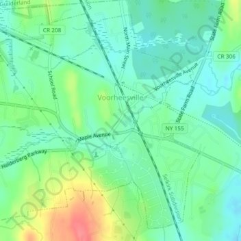
Nom : Carte topographique Village of Voorheesville, altitude, relief.
Altitude moyenne : 107 m
Altitude minimum : 86 m
Altitude maximum : 152 m
Autres cartes topographiques
Cliquez sur une carte pour visualiser sa topographie, son altitude et son relief.
Wolf Hill
United States > New York > Albany County > Town of New Scotland
Wolf Hill, Town of New Scotland, Albany County, New York, 12041, United States
Altitude moyenne : 385 m
Unionville
United States > New York > Albany County > Town of New Scotland
Unionville, Town of New Scotland, Albany County, New York, 12067, United States
Altitude moyenne : 88 m
Clarksville
United States > New York > Albany County > Town of New Scotland
Clarksville, Town of New Scotland, Albany County, New York, 12041, United States
Altitude moyenne : 243 m
Tarrytown
United States > New York > Albany County > Town of New Scotland
Tarrytown, Town of New Scotland, Albany County, New York, 12041, United States
Altitude moyenne : 222 m
New Salem
United States > New York > Albany County > Town of New Scotland
New Salem, Town of New Scotland, Albany County, New York, 12186, United States
Altitude moyenne : 212 m
Feura Bush
United States > New York > Albany County > Town of New Scotland
Feura Bush, Town of New Scotland, Albany County, New York, 12607, United States
Altitude moyenne : 95 m
John Boyd Thacher State Park
United States > New York > Albany County > Town of New Scotland
John Boyd Thacher State Park, Town of New Scotland, Albany County, New York, United States
Altitude moyenne : 262 m