Faire un don
Équipez-vous pour votre prochaine aventure :
En tant que Partenaire Amazon, ce site perçoit une commission sur les achats éligibles sans surcoût pour vous.
Carte topographique Beckermet
Cliquez sur la carte pour afficher l’altitude.
Faire un don
Équipez-vous pour votre prochaine aventure :
En tant que Partenaire Amazon, ce site perçoit une commission sur les achats éligibles sans surcoût pour vous.
À propos de cette carte
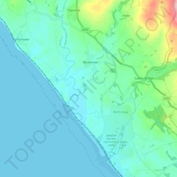
Nom : Carte topographique Beckermet, altitude, relief.
Lieu : Beckermet, Cumberland, England, United Kingdom (54.40366 -3.53612 54.46922 -3.48674)
Altitude moyenne : 38 m
Altitude minimum : -1 m
Altitude maximum : 234 m
Faire un don
Équipez-vous pour votre prochaine aventure :
En tant que Partenaire Amazon, ce site perçoit une commission sur les achats éligibles sans surcoût pour vous.
Autres cartes topographiques
Cliquez sur une carte pour visualiser sa topographie, son altitude et son relief.
Skiddaw
United Kingdom > England > Cumberland
Skiddaw is a mountain in the Lake District National Park in England. Its 931-metre (3,054 ft) summit is traditionally considered to be the fourth-highest peak but depending on what topographic prominence is thought to be significant is also variously ranked as the third- and the sixth-highest in England. It…
Altitude moyenne : 630 m
Scafell Pike
United Kingdom > England > Cumberland
Scafell Pike (/ˈskɔːfɛl paɪk/) is the highest and the most prominent mountain in England, at an elevation of 978 metres (3,209 ft) above sea level. It is located in the Lake District National Park, in Cumbria, and is part of the Southern Fells and the Scafell massif.
Altitude moyenne : 679 m
Faire un don
Équipez-vous pour votre prochaine aventure :
En tant que Partenaire Amazon, ce site perçoit une commission sur les achats éligibles sans surcoût pour vous.
Faire un don
Équipez-vous pour votre prochaine aventure :
En tant que Partenaire Amazon, ce site perçoit une commission sur les achats éligibles sans surcoût pour vous.
Faire un don
Équipez-vous pour votre prochaine aventure :
En tant que Partenaire Amazon, ce site perçoit une commission sur les achats éligibles sans surcoût pour vous.
Faire un don
Équipez-vous pour votre prochaine aventure :
En tant que Partenaire Amazon, ce site perçoit une commission sur les achats éligibles sans surcoût pour vous.
Whin Rigg
United Kingdom > England > Cumberland
Whin Rigg is a fell in the English Lake District, situated in the western segment of the national park, 22 kilometres (14 miles) south east of the town of Whitehaven. It reaches only a modest altitude of 535 m (1,755 ft) but is part of one of the Lake District’s most dramatic landscapes in that the rugged…
Altitude moyenne : 264 m
Faire un don
Équipez-vous pour votre prochaine aventure :
En tant que Partenaire Amazon, ce site perçoit une commission sur les achats éligibles sans surcoût pour vous.
Brund Fell (summit)
United Kingdom > England > Cumberland > Borrowdale
The fell has a summit plateau which consist of many heather-covered hummocks, drystone walls and clumps of trees. Well-known Lake District writer Alfred Wainwright credits Grange Fell as a single fell with three main summits, namely Brund Fell, King's How and Ether Knott. The lesser known Ether Knott is now…
Altitude moyenne : 252 m
Faire un don
Équipez-vous pour votre prochaine aventure :
En tant que Partenaire Amazon, ce site perçoit une commission sur les achats éligibles sans surcoût pour vous.
Harter Fell
United Kingdom > England > Cumberland > Ulpha
Harter Fell offers excellent insights into the structure and composition of the Birker Fell formation of the Ordovician Borrowdale Volcanic Group. The fell is dominantly composed of composite andesite lava flows, with autobrecciated upper surfaces developed in some locations. These are often seen in the field…
Altitude moyenne : 335 m
Fleetwith Pike
United Kingdom > England > Cumberland > Buttermere
The fell itself is often climbed in conjunction with other neighbouring fells such as Haystacks and Grey Knotts; strong walkers may also take in the peaks of Great Gable and Green Gable. There are two possible starting points for the ascent of Fleetwith Pike: these are Gatesgarth in the Buttermere valley and…
Altitude moyenne : 360 m
Faire un don
Équipez-vous pour votre prochaine aventure :
En tant que Partenaire Amazon, ce site perçoit une commission sur les achats éligibles sans surcoût pour vous.
Fellbarrow
United Kingdom > England > Cumberland
The two fells form a ridge 2 miles long with the lower Fellbarrow at the northern end. Alfred Wainwright in his influential Pictorial Guide to the Lakeland Fells was forced to estimate the elevation of Low Fell and considered (although with some doubts) Fellbarrow to be the high point of the ridge. There are a…
Altitude moyenne : 256 m
Crinkle Crags
United Kingdom > England > Cumberland > Ulpha
In recent times more systematic hill lists have been produced based upon topographical prominence and height, rather than mere visual appeal. Most relevant to Crinkle Crags are the lists of Hewitts and Nuttalls. These variously list the summit, the first Crinkle (Crinkle Crags South Top), and two tops on…
Altitude moyenne : 566 m
Faire un don
Équipez-vous pour votre prochaine aventure :
En tant que Partenaire Amazon, ce site perçoit une commission sur les achats éligibles sans surcoût pour vous.
Seatallan
United Kingdom > England > Cumberland
Seatallan is a mountain in the western part of the English Lake District. It is rounded, grassy and fairly unassuming, occupying a large amount of land. However, it is classed as a Marilyn because of the low elevation of the col connecting it to Haycock, its nearest higher neighbour to the north. The name…
Altitude moyenne : 452 m
Faire un don
Équipez-vous pour votre prochaine aventure :
En tant que Partenaire Amazon, ce site perçoit une commission sur les achats éligibles sans surcoût pour vous.
Crosby-on-Eden
United Kingdom > England > Cumberland > Low Crosby > High Crosby
Altitude moyenne : 22 m
Blea Tarn
United Kingdom > England > Cumberland > Boot > Beckfoot
Blea Tarn is a lake in Eskdale, Cumbria, in the English Lake District, located about half a mile north of Beckfoot. Located at an elevation of 217 m (712 ft), the lake has an area of 3.3 hectares (8.2 acres) and measures 277 m × 150 m (909 ft × 492 ft), with a maximum depth of 11 m (36 ft).
Altitude moyenne : 144 m
Faire un don
Équipez-vous pour votre prochaine aventure :
En tant que Partenaire Amazon, ce site perçoit une commission sur les achats éligibles sans surcoût pour vous.
Ling Fell
United Kingdom > England > Cumberland
Ling Fell and Sale Fell, despite standing side by side, have no topographical connection. Ling Fell's 'parent' is Broom Fell, while Sale Fell is an outlier of Lord's Seat. They are separated by the stream of Wythop Beck which drains a catchment to the east. The two fells act as portals to this shy valley as it…
Altitude moyenne : 249 m
Ard Crags
United Kingdom > England > Cumberland
Ard Crags is a fell in the Lake District in Cumbria, England, it is situated in the Newlands Valley just off the minor road between Keswick and Buttermere. The Ordnance Survey officially records the fell's altitude at 581 metres (1,906 ft), considerably more than the approximate 1,860 feet (570 m) that Alfred…
Altitude moyenne : 420 m
Faire un don
Équipez-vous pour votre prochaine aventure :
En tant que Partenaire Amazon, ce site perçoit une commission sur les achats éligibles sans surcoût pour vous.
Rannerdale Knotts
United Kingdom > England > Cumberland > Buttermere
The highest ground in the North Western Fells is an east-west ridge in this central sector, beginning with Grasmoor above Crummock Water and then gradually descending eastwards over Crag Hill, Sail, Scar Crags and Causey Pike. Grasmoor has the greatest elevation, but Crag Hill stands at the hub of the range.…
Altitude moyenne : 212 m
Esk Pike
United Kingdom > England > Cumberland
To the north-west of Esk Pike is the depression of Esk Hause, a broad saddle carrying a number of important paths. The ‘true’ Esk Hause—so named by Alfred Wainwright in his influential Pictorial Guide to the Lakeland Fells—is the north–south route from Borrowdale to Eskdale. A lower path—the…
Altitude moyenne : 652 m
Faire un don
Équipez-vous pour votre prochaine aventure :
En tant que Partenaire Amazon, ce site perçoit une commission sur les achats éligibles sans surcoût pour vous.
Black Combe
United Kingdom > England > Cumberland
Walks to the top of the fell begin at St Mary's Church, Whicham to the south; St Mary's Church, Whitbeck to the west or from the Corney Fell Road which crosses the fells at an altitude of 1,250 ft (380 m) 4 miles (6.4 km) to the north of the top. A more challenging and interesting route begins at Beckside Farm…
Altitude moyenne : 360 m
Former Seaton Ironworks Reservoir (disused)
United Kingdom > England > Cumberland > Workington > Stainburn
Altitude moyenne : 32 m
Faire un don
Équipez-vous pour votre prochaine aventure :
En tant que Partenaire Amazon, ce site perçoit une commission sur les achats éligibles sans surcoût pour vous.
Faire un don
Équipez-vous pour votre prochaine aventure :
En tant que Partenaire Amazon, ce site perçoit une commission sur les achats éligibles sans surcoût pour vous.
Setmurthy Common
United Kingdom > England > Cumberland > Embleton > Setmurthy
Altitude moyenne : 151 m
Faire un don
Équipez-vous pour votre prochaine aventure :
En tant que Partenaire Amazon, ce site perçoit une commission sur les achats éligibles sans surcoût pour vous.
Seathwaite Fell (Wainwright)
United Kingdom > England > Cumberland > Borrowdale
Altitude moyenne : 511 m
High Spy
United Kingdom > England > Cumberland
The fell reaches a height of 653 metres (2,142 feet) and is defended by crags to the east and west as it falls away steeply to the valleys. It is a distinctive fell that has 148 metres (486 feet) of topographic prominence from the higher adjoining fell of Dale Head and so misses being a Marilyn by only two…
Altitude moyenne : 404 m
Faire un don
Équipez-vous pour votre prochaine aventure :
En tant que Partenaire Amazon, ce site perçoit une commission sur les achats éligibles sans surcoût pour vous.
Scafell Pike
United Kingdom > England > Cumberland
Scafell Pike (/ˈskɔːfɛl/) is a hill in the Lake District region of Cumbria, England. It has an elevation of 978 metres (3,209 ft) above sea level, making it the highest and the most prominent mountain in England. The mountain is part of the Scafell massif, an extinct volcano, and is one of the Southern Fells.
Altitude moyenne : 679 m
Faire un don
Équipez-vous pour votre prochaine aventure :
En tant que Partenaire Amazon, ce site perçoit une commission sur les achats éligibles sans surcoût pour vous.
Faire un don
Équipez-vous pour votre prochaine aventure :
En tant que Partenaire Amazon, ce site perçoit une commission sur les achats éligibles sans surcoût pour vous.
Faire un don
Équipez-vous pour votre prochaine aventure :
En tant que Partenaire Amazon, ce site perçoit une commission sur les achats éligibles sans surcoût pour vous.
Scafell Pike
United Kingdom > England > Cumberland
Scafell Pike (/ˈskɔːfɛl/) is a mountain in the Lake District region of Cumbria, England. It has an elevation of 978 metres (3,209 ft) above sea level, making it the highest and the most prominent mountain in England. The mountain is part of the Scafell massif, an extinct volcano, and is one of the Southern…
Altitude moyenne : 679 m
Faire un don
Équipez-vous pour votre prochaine aventure :
En tant que Partenaire Amazon, ce site perçoit une commission sur les achats éligibles sans surcoût pour vous.
Scafell Pike
United Kingdom > England > Cumberland
Scafell Pike (/ˈskɔːfɛl/) is a mountain in the Lake District region of Cumbria, England. It has an elevation of 978 metres (3,209 ft) above sea level, making it the highest and the most prominent mountain in England. The mountain is part of the Scafell massif, an extinct volcano, and is one of the Southern…
Altitude moyenne : 679 m
Burnmoor Tarn
United Kingdom > England > Cumberland
The tarn is one of the sites in DEFRA's UK Upland Waters Monitoring Network. It occupies 23.9 hectares (59 acres) and lies at an altitude of 253 metres (830 ft) in a moraine hollow on the uplands between Wastwater and Eskdale. The lake has two distinct basins close to the south-eastern shore and a maximum…
Altitude moyenne : 345 m
Faire un don
Équipez-vous pour votre prochaine aventure :
En tant que Partenaire Amazon, ce site perçoit une commission sur les achats éligibles sans surcoût pour vous.
Faire un don
Équipez-vous pour votre prochaine aventure :
En tant que Partenaire Amazon, ce site perçoit une commission sur les achats éligibles sans surcoût pour vous.
High Rigg
United Kingdom > England > Cumberland
High Rigg is a small fell located in the English Lake District, approximately three miles southeast of the town of Keswick. It occupies an unusual position, surrounded on all sides by higher fells but not connected by any obvious ridge. This separation from its fellows ensures that it is a Marilyn (a hill with…
Altitude moyenne : 205 m
Faire un don
Équipez-vous pour votre prochaine aventure :
En tant que Partenaire Amazon, ce site perçoit une commission sur les achats éligibles sans surcoût pour vous.
Faire un don
Équipez-vous pour votre prochaine aventure :
En tant que Partenaire Amazon, ce site perçoit une commission sur les achats éligibles sans surcoût pour vous.
Hardknott Pass
United Kingdom > England > Cumberland > Ulpha
The Hardknott Pass stands at a maximum elevation of 393 m (1,289 ft). The road descends steeply at a gradient of 30% (1 in 3) into the Duddon Valley. At the eastern end of the pass is Cockley Beck farm, built in the 1860s and owned by the National Trust. The route from Hardknott leads eastward towards the…
Altitude moyenne : 323 m
Faire un don
Équipez-vous pour votre prochaine aventure :
En tant que Partenaire Amazon, ce site perçoit une commission sur les achats éligibles sans surcoût pour vous.
