
Carte topographique Sunderland
Cliquez sur la carte pour afficher l’altitude.
À propos de cette carte
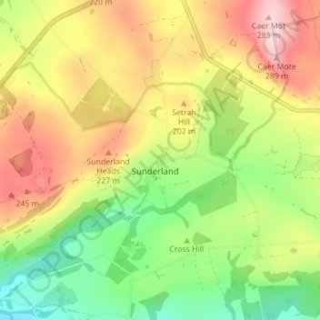
Nom : Carte topographique Sunderland, altitude, relief.
Altitude moyenne : 160 m
Altitude minimum : 59 m
Altitude maximum : 284 m
Autres cartes topographiques
Cliquez sur une carte pour visualiser sa topographie, son altitude et son relief.
Devoke Water
United Kingdom > England > Cumberland > Ulpha
Devoke Water is a small lake in the south west of the Lake District in North West England. It is the largest tarn in the Lake District, a tarn being a specific type of glacial lake formed when a hollow is created on a mountain. The lake is 1.17 kilometres (0.73 mi) long, has an area of 0.34 square kilometres…
Altitude moyenne : 260 m
Crinkle Crags
United Kingdom > England > Cumberland > Ulpha
In recent times more systematic hill lists have been produced based upon topographical prominence and height, rather than mere visual appeal. Most relevant to Crinkle Crags are the lists of Hewitts and Nuttalls. These variously list the summit, the first Crinkle (Crinkle Crags South Top), and two tops on…
Altitude moyenne : 566 m
Burnmoor Tarn
United Kingdom > England > Cumberland
The tarn is one of the sites in DEFRA's UK Upland Waters Monitoring Network. It occupies 23.9 hectares (59 acres) and lies at an altitude of 253 metres (830 ft) in a moraine hollow on the uplands between Wastwater and Eskdale. The lake has two distinct basins close to the south-eastern shore and a maximum…
Altitude moyenne : 345 m
Blea Tarn
United Kingdom > England > Cumberland > Boot > Beckfoot
Blea Tarn is a lake in Eskdale, Cumbria, in the English Lake District, located about half a mile north of Beckfoot. Located at an elevation of 217 m (712 ft), the lake has an area of 3.3 hectares (8.2 acres) and measures 277 m × 150 m (909 ft × 492 ft), with a maximum depth of 11 m (36 ft).
Altitude moyenne : 144 m
Cockermouth
United Kingdom > England > Cumberland
Cockermouth has a temperate climate that is influenced by the Irish Sea and its low-lying elevation. Cockermouth receives slightly below average rainfall compared with the UK average. Temperatures are also round about average compared with other parts of the UK. The nearest weather station for which online…
Altitude moyenne : 86 m
Setmurthy
United Kingdom > England > Cumberland
Watch Hill, also known as Setmurthy Common, reaches 254 metres (833 ft) and because of its relative isolation qualifies as a marilyn, a hill with 150 m of topographic prominence. Alfred Wainwright includes it in his The Outlying Fells of Lakeland, recommending an ascent from the west and a return on the same…
Altitude moyenne : 142 m
Former Seaton Ironworks Reservoir (disused)
United Kingdom > England > Cumberland > Workington > Stainburn
Altitude moyenne : 32 m
Solway Coast National Landscape
United Kingdom > England > Cumberland > Rockcliffe
Altitude moyenne : 53 m
Blindcrake
United Kingdom > England > Cumberland
The Isel valley has a temperate climate like much of the UK. However, it is one of the driest and sunniest parts of the Lake District. Summers are typically warm with some rain, with late spring to mid-summer tending to be the driest time of the year. Winters can be mild and wet, but due to the areas…
Altitude moyenne : 131 m
Cockermouth
United Kingdom > England > Cumberland
Cockermouth has a temperate climate that is influenced by the Irish Sea and its low-lying elevation; it receives slightly below average rainfall compared with the UK average. Temperatures are also about average compared with other parts of the UK. The nearest weather station, for which online records are…
Altitude moyenne : 82 m