
Faire un don
Équipez-vous pour votre prochaine aventure :
En tant que Partenaire Amazon, ce site perçoit une commission sur les achats éligibles sans surcoût pour vous.
Carte topographique Chaumox
Cliquez sur la carte pour afficher l’altitude.
Faire un don
Équipez-vous pour votre prochaine aventure :
En tant que Partenaire Amazon, ce site perçoit une commission sur les achats éligibles sans surcoût pour vous.
À propos de cette carte
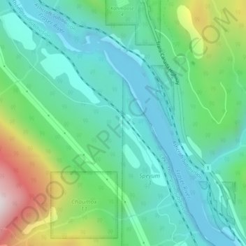
Nom : Carte topographique Chaumox, altitude, relief.
Altitude moyenne : 314 m
Altitude minimum : 98 m
Altitude maximum : 922 m
Faire un don
Équipez-vous pour votre prochaine aventure :
En tant que Partenaire Amazon, ce site perçoit une commission sur les achats éligibles sans surcoût pour vous.
Autres cartes topographiques
Cliquez sur une carte pour visualiser sa topographie, son altitude et son relief.
Mission
Canada > British Columbia > Fraser Valley Regional District
The western part of the district, the Stave Valley, is largely rural and forested but its watercourse is home to what was the largest hydroelectric project in British Columbia until the Bridge River Power Project opened in 1961. It was built by the British Columbia Electric Railway (BCER) to provide power to…
Altitude moyenne : 345 m
Faire un don
Équipez-vous pour votre prochaine aventure :
En tant que Partenaire Amazon, ce site perçoit une commission sur les achats éligibles sans surcoût pour vous.
Harrison Hot Springs
Canada > British Columbia > Fraser Valley Regional District
Altitude moyenne : 203 m
Area E (Chilliwack River Valley)
Canada > British Columbia > Fraser Valley Regional District
Altitude moyenne : 1 032 m
Harrison River
Canada > British Columbia > Fraser Valley Regional District > Kent > Harrison Mills
Altitude moyenne : 45 m
Sumas River
Canada > British Columbia > Fraser Valley Regional District > Abbotsford
Altitude moyenne : 167 m
Faire un don
Équipez-vous pour votre prochaine aventure :
En tant que Partenaire Amazon, ce site perçoit une commission sur les achats éligibles sans surcoût pour vous.
Harrison Lake
Canada > British Columbia > Fraser Valley Regional District > Area C (Sasquatch Country)
Altitude moyenne : 815 m
Stave Lake
Canada > British Columbia > Fraser Valley Regional District > Mission
Altitude moyenne : 573 m
Chehalis Lake
Canada > British Columbia > Fraser Valley Regional District > Area C (Sasquatch Country)
Altitude moyenne : 735 m
Chilliwack Lake
Canada > British Columbia > Fraser Valley Regional District > Area E (Chilliwack River Valley)
Altitude moyenne : 1 152 m
Faire un don
Équipez-vous pour votre prochaine aventure :
En tant que Partenaire Amazon, ce site perçoit une commission sur les achats éligibles sans surcoût pour vous.
Glacier Lake
Canada > British Columbia > Fraser Valley Regional District > Area C (Sasquatch Country)
Altitude moyenne : 614 m
Sloquet Creek
Canada > British Columbia > Fraser Valley Regional District > Area C (Sasquatch Country)
Altitude moyenne : 255 m
Campbell Lake
Canada > British Columbia > Fraser Valley Regional District > Kent
Altitude moyenne : 528 m
Faire un don
Équipez-vous pour votre prochaine aventure :
En tant que Partenaire Amazon, ce site perçoit une commission sur les achats éligibles sans surcoût pour vous.
Area F (McConnell Creek/Hatzic Prairie)
Canada > British Columbia > Fraser Valley Regional District
Altitude moyenne : 832 m
Falls Lake
Canada > British Columbia > Fraser Valley Regional District > Area B (South Fraser Canyon/Sunshine Valley)
Altitude moyenne : 1 512 m
Jones Lake
Canada > British Columbia > Fraser Valley Regional District > Area D (Popkum/Bridal Falls/Wahleach)
Altitude moyenne : 956 m
Stoney Creek Park
Canada > British Columbia > Fraser Valley Regional District > Abbotsford
Altitude moyenne : 40 m
Faire un don
Équipez-vous pour votre prochaine aventure :
En tant que Partenaire Amazon, ce site perçoit une commission sur les achats éligibles sans surcoût pour vous.
Hicks Lake
Canada > British Columbia > Fraser Valley Regional District > Kent
Altitude moyenne : 377 m
Area B (South Fraser Canyon/Sunshine Valley)
Canada > British Columbia > Fraser Valley Regional District
Altitude moyenne : 1 174 m
Sumas Prairie
Canada > British Columbia > Fraser Valley Regional District > Abbotsford
Altitude moyenne : 159 m
Cultus Lake
Canada > British Columbia > Fraser Valley Regional District > Area H (Cultus Lake/Columbia Valley) > Cultus Lake
Altitude moyenne : 191 m
Faire un don
Équipez-vous pour votre prochaine aventure :
En tant que Partenaire Amazon, ce site perçoit une commission sur les achats éligibles sans surcoût pour vous.
Isabel Lake
Canada > British Columbia > Fraser Valley Regional District > Area F (McConnell Creek/Hatzic Prairie)
Altitude moyenne : 687 m
Vedder River
Canada > British Columbia > Fraser Valley Regional District > Chilliwack
Altitude moyenne : 110 m
Area C (Sasquatch Country)
Canada > British Columbia > Fraser Valley Regional District
Altitude moyenne : 988 m
Chehalis River
Canada > British Columbia > Fraser Valley Regional District > Area C (Sasquatch Country)
Altitude moyenne : 424 m
Faire un don
Équipez-vous pour votre prochaine aventure :
En tant que Partenaire Amazon, ce site perçoit une commission sur les achats éligibles sans surcoût pour vous.
Misty Icefield
Canada > British Columbia > Fraser Valley Regional District > Area F (McConnell Creek/Hatzic Prairie)
Altitude moyenne : 1 800 m
Mamquam Icefield
Canada > British Columbia > Fraser Valley Regional District > Area F (McConnell Creek/Hatzic Prairie)
Altitude moyenne : 1 925 m
Hope Slide
Canada > British Columbia > Fraser Valley Regional District > Area B (South Fraser Canyon/Sunshine Valley)
Altitude moyenne : 1 160 m
Faire un don
Équipez-vous pour votre prochaine aventure :
En tant que Partenaire Amazon, ce site perçoit une commission sur les achats éligibles sans surcoût pour vous.
Area A (Boston Bar/North Bend/Canyon Alpine)
Canada > British Columbia > Fraser Valley Regional District
Altitude moyenne : 1 260 m
Area H (Cultus Lake/Columbia Valley)
Canada > British Columbia > Fraser Valley Regional District
Altitude moyenne : 566 m
Area G (Deroche/Dewdney/Sumas Mountain)
Canada > British Columbia > Fraser Valley Regional District > Area G (Deroche/Dewdney/Sumas Mountain)
Altitude moyenne : 211 m
Serpentine Lake
Canada > British Columbia > Fraser Valley Regional District > Area B (South Fraser Canyon/Sunshine Valley)
Altitude moyenne : 960 m
Faire un don
Équipez-vous pour votre prochaine aventure :
En tant que Partenaire Amazon, ce site perçoit une commission sur les achats éligibles sans surcoût pour vous.
Sumas Prairie
Canada > British Columbia > Fraser Valley Regional District > Abbotsford
Altitude moyenne : 159 m
Faire un don
Équipez-vous pour votre prochaine aventure :
En tant que Partenaire Amazon, ce site perçoit une commission sur les achats éligibles sans surcoût pour vous.
Mission
Canada > British Columbia > Fraser Valley Regional District
The western part of the district, the Stave Valley, is largely rural and forested but its watercourse is home to what was the largest hydroelectric project in British Columbia until the Bridge River Power Project opened in 1961. It was built by the British Columbia Electric Railway (BCER) to provide power to…
Altitude moyenne : 345 m
Harrison-Chehalis Wildlife Management Area
Canada > British Columbia > Fraser Valley Regional District > Area C (Sasquatch Country) > Harrison Mills
Altitude moyenne : 187 m
Area D (Popkum/Bridal Falls/Wahleach)
Canada > British Columbia > Fraser Valley Regional District
Altitude moyenne : 948 m
Faire un don
Équipez-vous pour votre prochaine aventure :
En tant que Partenaire Amazon, ce site perçoit une commission sur les achats éligibles sans surcoût pour vous.
Misty Icefield
Canada > British Columbia > Fraser Valley Regional District > Area F (McConnell Creek/Hatzic Prairie)
Altitude moyenne : 1 800 m
Faire un don
Équipez-vous pour votre prochaine aventure :
En tant que Partenaire Amazon, ce site perçoit une commission sur les achats éligibles sans surcoût pour vous.
Ryder Lake
Canada > British Columbia > Fraser Valley Regional District > Chilliwack
Altitude moyenne : 255 m
Area D (Popkum/Bridal Falls/Wahleach)
Canada > British Columbia > Fraser Valley Regional District
Altitude moyenne : 948 m
Area D (Popkum/Bridal Falls/Wahleach)
Canada > British Columbia > Fraser Valley Regional District
Altitude moyenne : 948 m
Area B (South Fraser Canyon/Sunshine Valley)
Canada > British Columbia > Fraser Valley Regional District
Altitude moyenne : 1 174 m
Faire un don
Équipez-vous pour votre prochaine aventure :
En tant que Partenaire Amazon, ce site perçoit une commission sur les achats éligibles sans surcoût pour vous.
Turner Glacier
Canada > British Columbia > Fraser Valley Regional District > Area C (Sasquatch Country)
Altitude moyenne : 2 183 m
Mission
Canada > British Columbia > Fraser Valley Regional District
The western part of the district, the Stave Valley, is largely rural and forested but its watercourse is home to what was the largest hydroelectric project in British Columbia until the Bridge River Power Project opened in 1961. It was built by the British Columbia Electric Railway (BCER) to provide power to…
Altitude moyenne : 345 m
Area B (South Fraser Canyon/Sunshine Valley)
Canada > British Columbia > Fraser Valley Regional District
Altitude moyenne : 1 174 m
Faire un don
Équipez-vous pour votre prochaine aventure :
En tant que Partenaire Amazon, ce site perçoit une commission sur les achats éligibles sans surcoût pour vous.