
Carte topographique Zondrangram
Carte interactive
Cliquez sur la carte pour afficher l’altitude.
À propos de cette carte
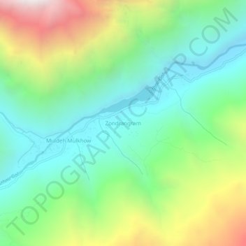
Nom : Carte topographique Zondrangram, altitude, relief.
Altitude moyenne : 3 111 m
Altitude minimum : 2 548 m
Altitude maximum : 4 257 m
Autres cartes topographiques
Cliquez sur une carte pour visualiser sa topographie, son altitude et son relief.
Mastuj
Pakistan > Khyber Pakhtunkhwa > Former Chitrāl District
Mastuj, Upper Chitral District, Former Chitrāl District, Malakand Division, Khyber Pakhtunkhwa, Pakistan
Altitude moyenne : 3 059 m
Water Flow
Pakistan > Khyber Pakhtunkhwa > Former Chitrāl District > Parsan
Water Flow, Parsan, Lower Chitral District, Former Chitrāl District, Malakand Division, Khyber Pakhtunkhwa, Pakistan
Altitude moyenne : 2 972 m