
Carte topographique Mastuj
Carte interactive
Cliquez sur la carte pour afficher l’altitude.
À propos de cette carte
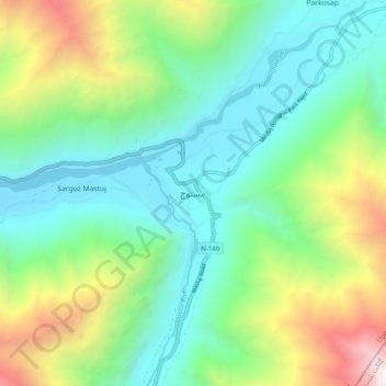
Nom : Carte topographique Mastuj, altitude, relief.
Altitude moyenne : 3 059 m
Altitude minimum : 2 238 m
Altitude maximum : 5 067 m
Mastuj (Urdu: مستوج) is a town and Tehsil of Upper Chitral District in Khyber-Pakhtunkhwa province of Pakistan. It is located at 36°17'0N 72°31'0E with an altitude of 2359 metres (7742 feet). There are ruins of old fort built originally in 18th century and reconstructed several times.
Autres cartes topographiques
Cliquez sur une carte pour visualiser sa topographie, son altitude et son relief.
Zondrangram
Pakistan > Khyber Pakhtunkhwa > Former Chitrāl District
Zondrangram, Upper Chitral District, Former Chitrāl District, Malakand Division, Khyber Pakhtunkhwa, Pakistan
Altitude moyenne : 3 111 m
Water Flow
Pakistan > Khyber Pakhtunkhwa > Former Chitrāl District > Parsan
Water Flow, Parsan, Lower Chitral District, Former Chitrāl District, Malakand Division, Khyber Pakhtunkhwa, Pakistan
Altitude moyenne : 2 972 m