
Carte topographique Walporzheim
Carte interactive
Cliquez sur la carte pour afficher l’altitude.
À propos de cette carte
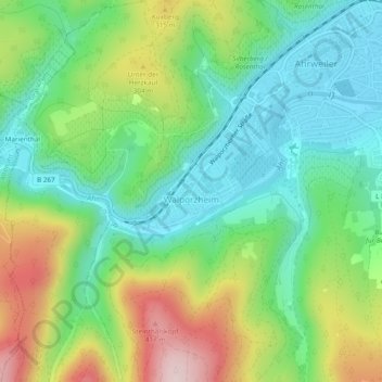
Nom : Carte topographique Walporzheim, altitude, relief.
Altitude moyenne : 219 m
Altitude minimum : 102 m
Altitude maximum : 439 m
Autres cartes topographiques
Cliquez sur une carte pour visualiser sa topographie, son altitude et son relief.
Ahrweiler
Deutschland > Rheinland-Pfalz > Landkreis Ahrweiler > Bad Neuenahr-Ahrweiler > Walporzheim
Ahrweiler, Walporzheim, Bad Neuenahr-Ahrweiler, Landkreis Ahrweiler, Rheinland-Pfalz, 53474, Deutschland
Altitude moyenne : 283 m
Ramersbach
Deutschland > Rheinland-Pfalz > Landkreis Ahrweiler > Bad Neuenahr-Ahrweiler
Ramersbach, Bad Neuenahr-Ahrweiler, Landkreis Ahrweiler, Rheinland-Pfalz, Deutschland
Altitude moyenne : 414 m
Lohrsdorf
Deutschland > Rheinland-Pfalz > Landkreis Ahrweiler > Bad Neuenahr-Ahrweiler
Lohrsdorf, Bad Neuenahr-Ahrweiler, Landkreis Ahrweiler, Rheinland-Pfalz, Deutschland
Altitude moyenne : 141 m
Marienthal
Deutschland > Rheinland-Pfalz > Landkreis Ahrweiler > Bad Neuenahr-Ahrweiler > Marienthal
Marienthal, Bad Neuenahr-Ahrweiler, Landkreis Ahrweiler, Rheinland-Pfalz, Deutschland
Altitude moyenne : 232 m
Neuenahr
Deutschland > Rheinland-Pfalz > Landkreis Ahrweiler > Bad Neuenahr-Ahrweiler
Neuenahr, Bad Neuenahr-Ahrweiler, Landkreis Ahrweiler, Rheinland-Pfalz, Deutschland
Altitude moyenne : 242 m
Neuenahrer Berg
Deutschland > Rheinland-Pfalz > Landkreis Ahrweiler > Bad Neuenahr-Ahrweiler
Neuenahrer Berg, Bad Neuenahr-Ahrweiler, Landkreis Ahrweiler, Rheinland-Pfalz, 53474, Deutschland
Altitude moyenne : 213 m