Carte topographique Deddington
Carte interactive
Cliquez sur la carte pour afficher l’altitude.
À propos de cette carte
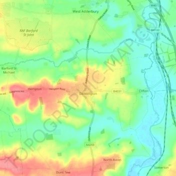
Clifton, Deddington and Hempton stand on a ridge of Jurassic ferruginous marlstone hills between the three watercourses. Clifton is about 1+1⁄2 miles (2.4 km) east of Deddington, at the eastern end of the ridge where it slopes down to the Cherwell. The ridges rises westward. Deddington is about 430 feet (130 m) above sea level. Hempton is about 1+1⁄2 miles (2.4 km) west of Deddington and about 489 feet (149 m) above sea level. The highest point of the ridge is on the western boundary of the parish, more than 490 feet (150 m) above sea level. The parish's topography is alluded to in a local rhyme:
Autres cartes topographiques
Cliquez sur une carte pour visualiser sa topographie, son altitude et son relief.
Twyford
United Kingdom > England > Oxfordshire > Cherwell District
Twyford, Cherwell District, Oxfordshire, England, OX17 3HS, United Kingdom
Altitude moyenne : 103 m
Shipton-on-Cherwell
United Kingdom > England > Oxfordshire > Cherwell District
Shipton-on-Cherwell, Cherwell District, Oxfordshire, England, OX5 1JN, United Kingdom
Altitude moyenne : 78 m
Swalcliffe
United Kingdom > England > Oxfordshire > Cherwell District
Swalcliffe, Cherwell District, Oxfordshire, England, United Kingdom
Altitude moyenne : 163 m
Fringford
United Kingdom > England > Oxfordshire > Cherwell District
Fringford, Cherwell District, Oxfordshire, England, United Kingdom
Altitude moyenne : 99 m
Noke
United Kingdom > England > Oxfordshire > Cherwell District
Noke, Cherwell District, Oxfordshire, England, United Kingdom
Altitude moyenne : 68 m
Souldern
United Kingdom > England > Oxfordshire > Cherwell District
Souldern, Cherwell District, Oxfordshire, England, United Kingdom
Altitude moyenne : 115 m
Hornton
United Kingdom > England > Oxfordshire > Cherwell District
Hornton, Cherwell District, Oxfordshire, England, United Kingdom
Altitude moyenne : 172 m
Water Eaton
United Kingdom > England > Oxfordshire > Cherwell District
Water Eaton, Gosford and Water Eaton, Cherwell District, Oxfordshire, England, OX2 8HD, United Kingdom
Altitude moyenne : 63 m
Wardington
United Kingdom > England > Oxfordshire > Cherwell District
Wardington, Cherwell District, Oxfordshire, England, United Kingdom
Altitude moyenne : 125 m
Merton
United Kingdom > England > Oxfordshire > Cherwell District
Merton, Cherwell District, Oxfordshire, England, United Kingdom
Altitude moyenne : 63 m
Fencott
United Kingdom > England > Oxfordshire > Cherwell District
Fencott, Cherwell District, Oxfordshire, England, OX5 2RD, United Kingdom
Altitude moyenne : 61 m
Epwell
United Kingdom > England > Oxfordshire > Cherwell District
Epwell, Cherwell District, Oxfordshire, England, United Kingdom
Altitude moyenne : 181 m
Stoke Lyne
United Kingdom > England > Oxfordshire > Cherwell District > Stoke Lyne
Stoke Lyne, Cherwell District, Oxfordshire, England, United Kingdom, Stoke Wood
Altitude moyenne : 116 m
Tadmarton
United Kingdom > England > Oxfordshire > Cherwell District
Tadmarton, Cherwell District, Oxfordshire, England, United Kingdom
Altitude moyenne : 143 m
The Lake
United Kingdom > England > Oxfordshire > Cherwell District > Hardwick
The Lake, Hardwick with Tusmore, Hardwick, Cherwell District, Oxfordshire, England, United Kingdom
Altitude moyenne : 120 m
Milton
United Kingdom > England > Oxfordshire > Cherwell District
Milton, Cherwell District, Oxfordshire, England, United Kingdom
Altitude moyenne : 111 m
Ambrosden
United Kingdom > England > Oxfordshire > Cherwell District
Ambrosden, Cherwell District, Oxfordshire, England, United Kingdom
Altitude moyenne : 66 m
Blackthorn
United Kingdom > England > Oxfordshire > Cherwell District
Blackthorn, Cherwell District, Oxfordshire, England, United Kingdom
Altitude moyenne : 64 m
Banbury
United Kingdom > England > Oxfordshire > Cherwell District
Banbury, Cherwell District, Oxfordshire, England, United Kingdom
Altitude moyenne : 116 m
Finmere
United Kingdom > England > Oxfordshire > Cherwell District
Finmere, Cherwell District, Oxfordshire, England, United Kingdom
Altitude moyenne : 114 m
Down End
United Kingdom > England > Oxfordshire > Cherwell District > Hook Norton
Down End, Hook Norton, Cherwell District, Oxfordshire, England, OX15 5LN, United Kingdom
Altitude moyenne : 173 m
Bicester
United Kingdom > England > Oxfordshire > Cherwell District
Bicester, Cherwell District, Oxfordshire, England, United Kingdom
Altitude moyenne : 76 m
Sibford Ferris
United Kingdom > England > Oxfordshire > Cherwell District
Sibford Ferris, Cherwell District, Oxfordshire, England, United Kingdom
Altitude moyenne : 173 m
Hempton
United Kingdom > England > Oxfordshire > Cherwell District
Hempton, Cherwell District, Oxfordshire, England, OX15 0QU, United Kingdom
Altitude moyenne : 112 m
Steeple Aston
United Kingdom > England > Oxfordshire > Cherwell District
Steeple Aston, Cherwell District, Oxfordshire, England, United Kingdom
Altitude moyenne : 107 m
Lower Heyford
United Kingdom > England > Oxfordshire > Cherwell District
Lower Heyford, Cherwell District, Oxfordshire, England, United Kingdom
Altitude moyenne : 99 m
Fewcott
United Kingdom > England > Oxfordshire > Cherwell District
Fewcott, Cherwell District, Oxfordshire, England, OX27 7NX, United Kingdom
Altitude moyenne : 120 m
Bucknell
United Kingdom > England > Oxfordshire > Cherwell District
Bucknell, Cherwell District, Oxfordshire, England, United Kingdom
Altitude moyenne : 98 m
Kidlington
United Kingdom > England > Oxfordshire > Cherwell District
Kidlington, Cherwell District, Oxfordshire, England, United Kingdom
Altitude moyenne : 68 m
Horton-cum-Studley
United Kingdom > England > Oxfordshire > Cherwell District > Horton-cum-Studley
Horton-cum-Studley, Cherwell District, Oxfordshire, England, United Kingdom
Altitude moyenne : 71 m
Adderbury
United Kingdom > England > Oxfordshire > Cherwell District
Adderbury, Cherwell District, Oxfordshire, England, United Kingdom
Altitude moyenne : 100 m
Cropredy
United Kingdom > England > Oxfordshire > Cherwell District
Cropredy, Cherwell District, Oxfordshire, England, United Kingdom
Altitude moyenne : 124 m
Williamscot
United Kingdom > England > Oxfordshire > Cherwell District > Cropredy > Williamscot
Williamscot, Wardington, Cropredy, Cherwell District, Oxfordshire, England, OX17 1AB, United Kingdom
Altitude moyenne : 118 m
Fritwell
United Kingdom > England > Oxfordshire > Cherwell District
Fritwell, Cherwell District, Oxfordshire, England, United Kingdom
Altitude moyenne : 128 m
Wroxton
United Kingdom > England > Oxfordshire > Cherwell District
Wroxton, Cherwell District, Oxfordshire, England, United Kingdom
Altitude moyenne : 146 m
Islip
United Kingdom > England > Oxfordshire > Cherwell District > Islip
Islip, Cherwell District, Oxfordshire, South East England, England, United Kingdom
Altitude moyenne : 65 m
Kirtlington
United Kingdom > England > Oxfordshire > Cherwell District
Kirtlington, Cherwell District, Oxfordshire, England, United Kingdom
Altitude moyenne : 89 m
North Aston
United Kingdom > England > Oxfordshire > Cherwell District
North Aston, Cherwell District, Oxfordshire, England, United Kingdom
Altitude moyenne : 101 m
South Newington
United Kingdom > England > Oxfordshire > Cherwell District
South Newington, Cherwell District, Oxfordshire, England, United Kingdom
Altitude moyenne : 139 m
Ardley
United Kingdom > England > Oxfordshire > Cherwell District
Ardley, Cherwell District, Oxfordshire, England, United Kingdom
Altitude moyenne : 119 m
Bodicote
United Kingdom > England > Oxfordshire > Cherwell District
Bodicote, Cherwell District, Oxfordshire, England, United Kingdom
Altitude moyenne : 114 m
Arncott
United Kingdom > England > Oxfordshire > Cherwell District
Arncott, Cherwell District, Oxfordshire, England, United Kingdom
Altitude moyenne : 68 m
Launton
United Kingdom > England > Oxfordshire > Cherwell District
Launton, Cherwell District, Oxfordshire, England, United Kingdom
Altitude moyenne : 73 m
Wigginton
United Kingdom > England > Oxfordshire > Cherwell District
Wigginton, Cherwell District, Oxfordshire, England, United Kingdom
Altitude moyenne : 154 m
Bloxham
United Kingdom > England > Oxfordshire > Cherwell District
Bloxham, Cherwell District, Oxfordshire, England, United Kingdom
Altitude moyenne : 115 m
Hook Norton
United Kingdom > England > Oxfordshire > Cherwell District
Hook Norton, Cherwell District, Oxfordshire, England, United Kingdom
Altitude moyenne : 172 m
Oddington
United Kingdom > England > Oxfordshire > Cherwell District
Oddington, Cherwell District, Oxfordshire, England, United Kingdom
Altitude moyenne : 62 m
Upper Heyford
United Kingdom > England > Oxfordshire > Cherwell District
Upper Heyford, Cherwell District, Oxfordshire, England, United Kingdom
Altitude moyenne : 101 m
Duns Tew
United Kingdom > England > Oxfordshire > Cherwell District
Duns Tew, Cherwell District, Oxfordshire, England, United Kingdom
Altitude moyenne : 125 m
Milcombe
United Kingdom > England > Oxfordshire > Cherwell District
Milcombe, Cherwell District, Oxfordshire, England, United Kingdom
Altitude moyenne : 146 m