
Carte topographique Zaragoza
Carte interactive
Cliquez sur la carte pour afficher l’altitude.
À propos de cette carte
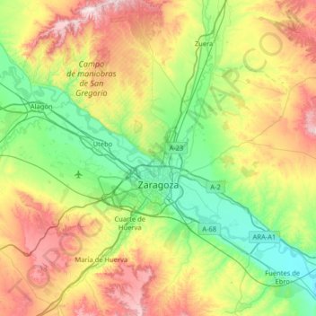
Nom : Carte topographique Zaragoza, altitude, relief.
Lieu : Zaragoza, Aragon, Spain (41.45166 -1.17373 41.93149 -0.68039)
Altitude moyenne : 361 m
Altitude minimum : 160 m
Altitude maximum : 752 m
On 1 January 2021 the population of the municipality of Zaragoza was 675,301, (the fifth most populated in Spain) on a land area of 973.78 square kilometres (375.98 square miles). The population of the metropolitan area was estimated in 2006 at 783,763 inhabitants. The municipality is home to more than 50 percent of the Aragonese population. The city lies at an elevation of about 208 metres (682 feet) above sea level.
Autres cartes topographiques
Cliquez sur une carte pour visualiser sa topographie, son altitude et son relief.