
Faire un don
Équipez-vous pour votre prochaine aventure :
En tant que Partenaire Amazon, ce site perçoit une commission sur les achats éligibles sans surcoût pour vous.
Carte topographique Twin Butte
Cliquez sur la carte pour afficher l’altitude.
Faire un don
Équipez-vous pour votre prochaine aventure :
En tant que Partenaire Amazon, ce site perçoit une commission sur les achats éligibles sans surcoût pour vous.
À propos de cette carte
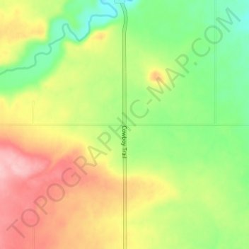
Nom : Carte topographique Twin Butte, altitude, relief.
Altitude moyenne : 1 364 m
Altitude minimum : 1 299 m
Altitude maximum : 1 439 m
Faire un don
Équipez-vous pour votre prochaine aventure :
En tant que Partenaire Amazon, ce site perçoit une commission sur les achats éligibles sans surcoût pour vous.
Autres cartes topographiques
Cliquez sur une carte pour visualiser sa topographie, son altitude et son relief.
Castle Provincial Park
Canada > Alberta > Municipal District of Pincher Creek No. 9
The Castle Provincial Park has a unique climate which has allowed the growth of many unique plant and animal species. This climate is formed because of the transition of subalpine forest to tundra, and is characterized by short summers interchanged with long, snowy winters. Precipitation varies throughout the…
Altitude moyenne : 1 587 m
Carbondale River
Canada > Alberta > Municipal District of Pincher Creek No. 9
Altitude moyenne : 1 565 m
Beaver Mines Lake
Canada > Alberta > Municipal District of Pincher Creek No. 9
Altitude moyenne : 1 538 m
Faire un don
Équipez-vous pour votre prochaine aventure :
En tant que Partenaire Amazon, ce site perçoit une commission sur les achats éligibles sans surcoût pour vous.