
Faire un don
Équipez-vous pour votre prochaine aventure :
En tant que Partenaire Amazon, ce site perçoit une commission sur les achats éligibles sans surcoût pour vous.
Carte topographique La Cañada
Cliquez sur la carte pour afficher l’altitude.
Faire un don
Équipez-vous pour votre prochaine aventure :
En tant que Partenaire Amazon, ce site perçoit une commission sur les achats éligibles sans surcoût pour vous.
À propos de cette carte
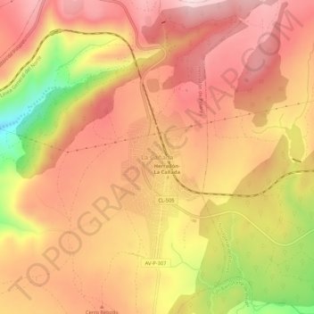
Nom : Carte topographique La Cañada, altitude, relief.
Altitude moyenne : 1 360 m
Altitude minimum : 1 128 m
Altitude maximum : 1 485 m
Faire un don
Équipez-vous pour votre prochaine aventure :
En tant que Partenaire Amazon, ce site perçoit une commission sur les achats éligibles sans surcoût pour vous.
Autres cartes topographiques
Cliquez sur une carte pour visualiser sa topographie, son altitude et son relief.
Burgos
At an elevation of 865 metres (2,838 ft), the city of Burgos lies in the transition zone between a Warm-summer Mediterranean climate (Köppen Csb) and an Oceanic climate (Köppen Cfb), with some continental influence resulting from its distance from the sea and higher altitude. Burgos' climate features chilly…
Altitude moyenne : 907 m
Segovia
Segovia is one of nine provinces that make up the autonomous region of Castile and León. Burgos and Valladolid lie to the north, Ávila to the west, Madrid to the south, and Soria to the east. The altitude of the province varies from 750 metres (2,461 feet) in the extreme northwest to a maximum of 2,430 m…
Altitude moyenne : 1 143 m
Faire un don
Équipez-vous pour votre prochaine aventure :
En tant que Partenaire Amazon, ce site perçoit une commission sur les achats éligibles sans surcoût pour vous.
Palencia
The region of Palencia has a Continental Mediterranean climate with cool winters, due to altitude (749 m) and isolation from maritime influences, chilly winds, including some days of snow in the winter and minimum temperatures usually below 0 °C (32 °F). Fog is frequent because of the Carrion river. Summers…
Altitude moyenne : 794 m
Faire un don
Équipez-vous pour votre prochaine aventure :
En tant que Partenaire Amazon, ce site perçoit une commission sur les achats éligibles sans surcoût pour vous.
Valladolid
Valladolid is located at roughly 735 metres above sea level, at the centre of the Meseta Norte, the plateau drained by the Duero river basin covering a major part of the Northwest of the Iberian Peninsula. The primitive urban core was built ex novo in the 11th century on a small elevation near the confluence…
Altitude moyenne : 768 m
Faire un don
Équipez-vous pour votre prochaine aventure :
En tant que Partenaire Amazon, ce site perçoit une commission sur les achats éligibles sans surcoût pour vous.
Salamanca
With an altitude of over 800 meters, Salamanca has a warm-summer Mediterranean climate (Csb) according to the Köppen climate classification, with some cold semi-arid climate (BSk) climatic influences, resulting in large diurnal temperature variations, with hot summers and chilly winters, and nearly-semi-arid…
Altitude moyenne : 812 m
Valladolid
Valladolid is located at roughly 735 metres above sea level, at the centre of the Meseta Norte, the plateau drained by the Duero river basin covering a major part of the Northwest of the Iberian Peninsula. The primitive urban core was built ex novo in the 11th century on a small elevation near the confluence…
Altitude moyenne : 768 m
Faire un don
Équipez-vous pour votre prochaine aventure :
En tant que Partenaire Amazon, ce site perçoit une commission sur les achats éligibles sans surcoût pour vous.
Ciudad Rodrigo
At an elevation of 658 metres (2,159 ft) Ciudad Rodrigo has an inland Mediterranean climate (Köppen: Csb) characterised by cool, damp winters and warm, dry summers with relatively cool nights during the summer.
Altitude moyenne : 709 m
Faire un don
Équipez-vous pour votre prochaine aventure :
En tant que Partenaire Amazon, ce site perçoit une commission sur les achats éligibles sans surcoût pour vous.
Segovia
Segovia has a hot-summer Mediterranean climate (Csa in the Köppen climate classification) bordering on a cold semi-arid climate (BSk), resulting from the high altitude and the distance from the coast. The average annual temperature is 12.42 °C (54.4 °F), with an average low in January of 0.3 °C (32.5 °F)…
Altitude moyenne : 1 143 m
Ciudad Rodrigo
At an elevation of 658 metres (2,159 ft) Ciudad Rodrigo has an inland Mediterranean climate (Köppen: Csb) characterised by cool, damp winters and warm, dry summers with relatively cool nights during the summer.
Altitude moyenne : 709 m
Faire un don
Équipez-vous pour votre prochaine aventure :
En tant que Partenaire Amazon, ce site perçoit une commission sur les achats éligibles sans surcoût pour vous.
Faire un don
Équipez-vous pour votre prochaine aventure :
En tant que Partenaire Amazon, ce site perçoit une commission sur les achats éligibles sans surcoût pour vous.
Faire un don
Équipez-vous pour votre prochaine aventure :
En tant que Partenaire Amazon, ce site perçoit une commission sur les achats éligibles sans surcoût pour vous.
Faire un don
Équipez-vous pour votre prochaine aventure :
En tant que Partenaire Amazon, ce site perçoit une commission sur les achats éligibles sans surcoût pour vous.
Faire un don
Équipez-vous pour votre prochaine aventure :
En tant que Partenaire Amazon, ce site perçoit une commission sur les achats éligibles sans surcoût pour vous.
Faire un don
Équipez-vous pour votre prochaine aventure :
En tant que Partenaire Amazon, ce site perçoit une commission sur les achats éligibles sans surcoût pour vous.
Faire un don
Équipez-vous pour votre prochaine aventure :
En tant que Partenaire Amazon, ce site perçoit une commission sur les achats éligibles sans surcoût pour vous.
Burgos
At an elevation of 865 metres (2,838 ft), the city of Burgos has a warm-summer Mediterranean climate (Köppen climate classification: Csb, with some continental influence resulting from its distance from the sea and higher altitude. It features chilly and windy winters, due to altitude and an inland location,…
Altitude moyenne : 907 m
Faire un don
Équipez-vous pour votre prochaine aventure :
En tant que Partenaire Amazon, ce site perçoit une commission sur les achats éligibles sans surcoût pour vous.
Faire un don
Équipez-vous pour votre prochaine aventure :
En tant que Partenaire Amazon, ce site perçoit une commission sur les achats éligibles sans surcoût pour vous.
El Espinar
The documented history of El Espinar dates from the 11th century, even though the area has been inhabited since the Iron Age. In fact, in September 2016 was found the settlement of Canto Los Hierros in a nearby mountain located south of town, just at 1,700 metres above sea level. The settlement, dated back to…
Altitude moyenne : 1 324 m
Faire un don
Équipez-vous pour votre prochaine aventure :
En tant que Partenaire Amazon, ce site perçoit une commission sur les achats éligibles sans surcoût pour vous.
Burgos
At an elevation of 865 metres (2,838 ft), the city of Burgos has a warm-summer Mediterranean climate (Köppen climate classification: Csb, with some continental influence resulting from its distance from the sea and higher altitude. It features chilly and windy winters, due to altitude and an inland location,…
Altitude moyenne : 907 m
Faire un don
Équipez-vous pour votre prochaine aventure :
En tant que Partenaire Amazon, ce site perçoit une commission sur les achats éligibles sans surcoût pour vous.
Faire un don
Équipez-vous pour votre prochaine aventure :
En tant que Partenaire Amazon, ce site perçoit une commission sur les achats éligibles sans surcoût pour vous.
Ávila
Ávila's position results in a temperate Mediterranean climate (Csb, according to the Köppen climate classification), with warm summers and chilly winters with snowfalls, bordering on a cold semi-arid climate (BSk). The hottest month, July, has an average temperature of 20.6 °C (69 °F), and the coldest…
Altitude moyenne : 1 157 m
Burgos
At an elevation of 865 metres (2,838 ft), the city of Burgos lies in the transition zone between a Warm-summer Mediterranean climate (Köppen Csb) and an Oceanic climate (Köppen Cfb), with some continental influence resulting from its distance from the sea and higher altitude. Burgos' climate features chilly…
Altitude moyenne : 907 m
Benavente
Benavente is characterized by a cold semi-arid climate in the Köppen climate classification (BSk) with continental influences due to the altitude of the municipality and its distance to the sea. The amount of winter frosts is increased, taking place even in spring, with consequential damage to some of the…
Altitude moyenne : 716 m
Faire un don
Équipez-vous pour votre prochaine aventure :
En tant que Partenaire Amazon, ce site perçoit une commission sur les achats éligibles sans surcoût pour vous.
El Barco de Ávila
El Barco de Ávila is located at the southwest of the province of Avila, near the frontier of the provinces of Salamanca and Caceres, being the headboard of the region between the valley of the Tormes river and Aravalles river, better known as Alto Tormes. This municipality is located on an altitude of 1004…
Altitude moyenne : 1 061 m
Faire un don
Équipez-vous pour votre prochaine aventure :
En tant que Partenaire Amazon, ce site perçoit une commission sur les achats éligibles sans surcoût pour vous.
Salamanca
The city is located at an altitude of 800 meters above sea level. The altitude of the municipality varies from 911 meters (Los Montalvos), in the southwest, and 763 meters in the last stretch in the municipality of the Tormes river.
Altitude moyenne : 812 m
Faire un don
Équipez-vous pour votre prochaine aventure :
En tant que Partenaire Amazon, ce site perçoit une commission sur les achats éligibles sans surcoût pour vous.
Faire un don
Équipez-vous pour votre prochaine aventure :
En tant que Partenaire Amazon, ce site perçoit une commission sur les achats éligibles sans surcoût pour vous.
Faire un don
Équipez-vous pour votre prochaine aventure :
En tant que Partenaire Amazon, ce site perçoit une commission sur les achats éligibles sans surcoût pour vous.
Faire un don
Équipez-vous pour votre prochaine aventure :
En tant que Partenaire Amazon, ce site perçoit une commission sur les achats éligibles sans surcoût pour vous.
Yacimiento arqueológico La Edrada
Spain > Castile and León > El Bierzo > Cacabelos
Altitude moyenne : 493 m
Faire un don
Équipez-vous pour votre prochaine aventure :
En tant que Partenaire Amazon, ce site perçoit une commission sur les achats éligibles sans surcoût pour vous.
Burgos
At an elevation of 865 metres (2,838 ft), the city of Burgos has a warm-summer Mediterranean climate (Köppen climate classification: Csb, with some continental influence resulting from its distance from the sea and higher altitude. It features chilly and windy winters, due to altitude and an inland location,…
Altitude moyenne : 907 m
Faire un don
Équipez-vous pour votre prochaine aventure :
En tant que Partenaire Amazon, ce site perçoit une commission sur les achats éligibles sans surcoût pour vous.