
Faire un don
Équipez-vous pour votre prochaine aventure :
En tant que Partenaire Amazon, ce site perçoit une commission sur les achats éligibles sans surcoût pour vous.
Carte topographique Stonebeck Up
Cliquez sur la carte pour afficher l’altitude.
Faire un don
Équipez-vous pour votre prochaine aventure :
En tant que Partenaire Amazon, ce site perçoit une commission sur les achats éligibles sans surcoût pour vous.
À propos de cette carte
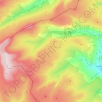
Nom : Carte topographique Stonebeck Up, altitude, relief.
Altitude moyenne : 441 m
Altitude minimum : 161 m
Altitude maximum : 704 m
Faire un don
Équipez-vous pour votre prochaine aventure :
En tant que Partenaire Amazon, ce site perçoit une commission sur les achats éligibles sans surcoût pour vous.
Autres cartes topographiques
Cliquez sur une carte pour visualiser sa topographie, son altitude et son relief.
Faire un don
Équipez-vous pour votre prochaine aventure :
En tant que Partenaire Amazon, ce site perçoit une commission sur les achats éligibles sans surcoût pour vous.
Killinghall
United Kingdom > England > North Yorkshire > Harrogate > Killinghall
Altitude moyenne : 86 m
Dent Crag Ridge
United Kingdom > England > North Yorkshire > Harrogate > Dacre
Altitude moyenne : 301 m
Faire un don
Équipez-vous pour votre prochaine aventure :
En tant que Partenaire Amazon, ce site perçoit une commission sur les achats éligibles sans surcoût pour vous.
Upper Dunsforth
United Kingdom > England > North Yorkshire > Harrogate > Upper Dunsforth
Altitude moyenne : 24 m
Faire un don
Équipez-vous pour votre prochaine aventure :
En tant que Partenaire Amazon, ce site perçoit une commission sur les achats éligibles sans surcoût pour vous.
Marston Moor
United Kingdom > England > North Yorkshire > Harrogate > Long Marston
Altitude moyenne : 24 m