
Carte topographique Buffalo National River
Carte interactive
Cliquez sur la carte pour afficher l’altitude.
À propos de cette carte
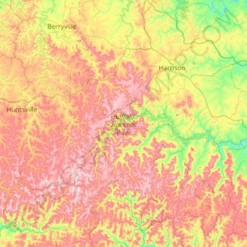
Nom : Carte topographique Buffalo National River, altitude, relief.
Altitude moyenne : 444 m
Altitude minimum : 186 m
Altitude maximum : 775 m
Along the upper river, the gradient is steep and the water is fast, leveling and slowing as the river runs its course. The upper section has most of the whitewater rapids to be found along the river, and features dramatic karst topography including sink holes and caves, springs, and waterfalls, over 500-foot (150 m) tall sandstone and limestone bluffs, and many rock formations. At one point, a 0.65-mile (1.05 km) hike from the river up a narrow, boxed canyon leads to a 209-foot (64 m) waterfall, Hemmed-In-Hollow Falls, the highest of its kind between the Southern Appalachians and the Rockies. The river's current also gives life to well over 300 species of fish, insects, freshwater mussels, and aquatic plants.
Autres cartes topographiques
Cliquez sur une carte pour visualiser sa topographie, son altitude et son relief.
Lead Hill
United States > Arkansas > Searcy County
Lead Hill, Searcy County, Arkansas, United States
Altitude moyenne : 286 m
Saint Joe
United States > Arkansas > Searcy County
Saint Joe, Searcy County, Arkansas, 72675, United States
Altitude moyenne : 260 m
Gilbert
United States > Arkansas > Searcy County
Gilbert, Searcy County, Arkansas, 72636, United States
Altitude moyenne : 216 m
Buffalo River
United States > Arkansas > Searcy County > Gilbert
Buffalo River, Gilbert, Searcy County, Arkansas, 72636, United States
Altitude moyenne : 217 m
Leslie
United States > Arkansas > Searcy County > Leslie > Leslie
Leslie, Searcy County, Arkansas, 72645, United States
Altitude moyenne : 347 m
Cozahome
United States > Arkansas > Searcy County > Cozahome
Cozahome, Searcy County, Arkansas, United States
Altitude moyenne : 307 m
Marshall
United States > Arkansas > Searcy County
Marshall, Searcy County, Arkansas, 72650, United States
Altitude moyenne : 331 m