
Carte topographique Marshall
Carte interactive
Cliquez sur la carte pour afficher l’altitude.
À propos de cette carte
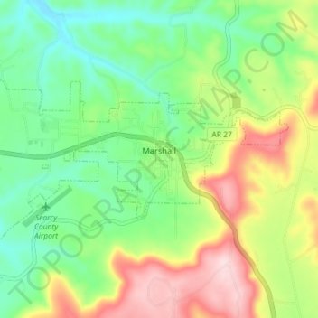
Nom : Carte topographique Marshall, altitude, relief.
Lieu : Marshall, Searcy County, Arkansas, 72650, United States (35.89277 -92.67378 35.92193 -92.60221)
Altitude moyenne : 331 m
Altitude minimum : 226 m
Altitude maximum : 503 m
For bicycling, the Ozark Grinder Trail is a nearby gravel grinder bicycle trail covering approximately 200 miles and 13,000 feet of elevation in north central Arkansas Ozarks. The annual Arkansaw High Country Race transits through Marshall each June. This event is an approximately 1,034-mile self-supported (bikepacking) gravel cycling race with approximately 84,000 feet of total elevation.
Autres cartes topographiques
Cliquez sur une carte pour visualiser sa topographie, son altitude et son relief.
Lead Hill
United States > Arkansas > Searcy County
Lead Hill, Searcy County, Arkansas, United States
Altitude moyenne : 286 m
Saint Joe
United States > Arkansas > Searcy County
Saint Joe, Searcy County, Arkansas, 72675, United States
Altitude moyenne : 260 m
Gilbert
United States > Arkansas > Searcy County
Gilbert, Searcy County, Arkansas, 72636, United States
Altitude moyenne : 216 m
Buffalo River
United States > Arkansas > Searcy County > Gilbert
Buffalo River, Gilbert, Searcy County, Arkansas, 72636, United States
Altitude moyenne : 217 m
Buffalo National River
United States > Arkansas > Searcy County
Buffalo National River, Searcy County, Arkansas, 72624, United States
Altitude moyenne : 444 m
Leslie
United States > Arkansas > Searcy County > Leslie > Leslie
Leslie, Searcy County, Arkansas, 72645, United States
Altitude moyenne : 347 m
Cozahome
United States > Arkansas > Searcy County > Cozahome
Cozahome, Searcy County, Arkansas, United States
Altitude moyenne : 307 m