
Faire un don
Équipez-vous pour votre prochaine aventure :
En tant que Partenaire Amazon, ce site perçoit une commission sur les achats éligibles sans surcoût pour vous.
Carte topographique Brule
Cliquez sur la carte pour afficher l’altitude.
Faire un don
Équipez-vous pour votre prochaine aventure :
En tant que Partenaire Amazon, ce site perçoit une commission sur les achats éligibles sans surcoût pour vous.
À propos de cette carte
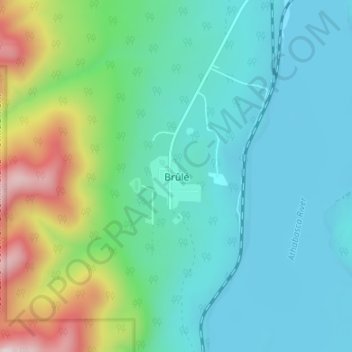
Nom : Carte topographique Brule, altitude, relief.
Lieu : Brule, Yellowhead County, Alberta, Canada (53.29038 -117.88925 53.33038 -117.84925)
Altitude moyenne : 1 135 m
Altitude minimum : 979 m
Altitude maximum : 1 659 m
Faire un don
Équipez-vous pour votre prochaine aventure :
En tant que Partenaire Amazon, ce site perçoit une commission sur les achats éligibles sans surcoût pour vous.
Autres cartes topographiques
Cliquez sur une carte pour visualiser sa topographie, son altitude et son relief.
Brazeau River Provincial Recreation Area
Canada > Alberta > Yellowhead County
Altitude moyenne : 1 325 m
Faire un don
Équipez-vous pour votre prochaine aventure :
En tant que Partenaire Amazon, ce site perçoit une commission sur les achats éligibles sans surcoût pour vous.
William A. Switzer Provincial Park
Canada > Alberta > Yellowhead County
This park is situated within the foothills of Alberta's Rocky Mountains, at an elevation of 1,150 m (3,770 ft) to 1,300 m (4,300 ft) and has a surface of 93 km2 (36 sq mi). It was established on December 22, 1958 and is maintained by Alberta Tourism, Parks and Recreation. The park is named after former…
Altitude moyenne : 1 348 m