
Faire un don
Équipez-vous pour votre prochaine aventure :
En tant que Partenaire Amazon, ce site perçoit une commission sur les achats éligibles sans surcoût pour vous.
Carte topographique Drosh Tehsil
Cliquez sur la carte pour afficher l’altitude.
Faire un don
Équipez-vous pour votre prochaine aventure :
En tant que Partenaire Amazon, ce site perçoit une commission sur les achats éligibles sans surcoût pour vous.
Drosh Tehsil
Khowar is by the majority of the people in Drosh with a few speakers of Pashto. Drosh is low elevation and is a large village in Chitral District on the traditional trade route to Drosh-Jalalabad Road.
Faire un don
Équipez-vous pour votre prochaine aventure :
En tant que Partenaire Amazon, ce site perçoit une commission sur les achats éligibles sans surcoût pour vous.
À propos de cette carte
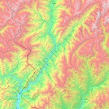
Nom : Carte topographique Drosh Tehsil, altitude, relief.
Altitude moyenne : 3 012 m
Altitude minimum : 1 024 m
Altitude maximum : 5 681 m
Faire un don
Équipez-vous pour votre prochaine aventure :
En tant que Partenaire Amazon, ce site perçoit une commission sur les achats éligibles sans surcoût pour vous.
Autres cartes topographiques
Cliquez sur une carte pour visualiser sa topographie, son altitude et son relief.
Zargirandeh
Pakistan > Khyber Pakhtunkhwa > Chitrāl District > Chitral Tehsil
Altitude moyenne : 2 043 m
Chitral
Pakistan > Khyber Pakhtunkhwa > Chitrāl District
The city has an average elevation of 1,500 m (4,921 ft).
Altitude moyenne : 2 982 m
Chitral
Pakistan > Khyber Pakhtunkhwa > Chitrāl District
The city has an average elevation of 1,500 m (4,921 ft).
Altitude moyenne : 2 982 m
Faire un don
Équipez-vous pour votre prochaine aventure :
En tant que Partenaire Amazon, ce site perçoit une commission sur les achats éligibles sans surcoût pour vous.
Drosh
Pakistan > Khyber Pakhtunkhwa > Chitrāl District
Drosh is low elevation and is a large village in Chitral District on the traditional trade route to Drosh-Jalalabad Road. Drosh is located on 35° 33' 33" N and 71° 47' 44" E on the banks of the Landai Sin River (Bashgal River) just above its intersection with the Kunar River (Chitral River), along the…
Altitude moyenne : 1 851 m
Junali Kuch
Pakistan > Khyber Pakhtunkhwa > Chitrāl District > Torkhow-Molkhow Tehsil
Altitude moyenne : 2 198 m
Tirich Mir
Pakistan > Khyber Pakhtunkhwa > Chitrāl District > Torkhow-Molkhow Tehsil
The weather station 4,245 m (13,927 ft) above sea level lies in the Tundra climate/Alpine climate (ET) zone according to Köppen Climate Classification. On this specific altitude (4,245 m or 13,927 ft asl) we find moderately cold winters and cool summers generally above freezing. Annual mean temperature is…
Altitude moyenne : 6 802 m
Faire un don
Équipez-vous pour votre prochaine aventure :
En tant que Partenaire Amazon, ce site perçoit une commission sur les achats éligibles sans surcoût pour vous.
Drosh
Pakistan > Khyber Pakhtunkhwa > Chitrāl District
Drosh is low elevation and is a large village in Chitral District on the traditional trade route to Drosh-Jalalabad Road. Drosh is located on 35° 33' 33" N and 71° 47' 44" E on the banks of the Landai Sin River (Bashgal River) just above its intersection with the Kunar River (Chitral River), along the…
Altitude moyenne : 1 851 m
Chitral
Pakistan > Khyber Pakhtunkhwa > Chitrāl District
The city has an average elevation of 1,500 m (4,921 ft).
Altitude moyenne : 2 982 m
Noshaq
Pakistan > Khyber Pakhtunkhwa > Chitrāl District > Torkhow-Molkhow Tehsil
Altitude moyenne : 6 868 m
Faire un don
Équipez-vous pour votre prochaine aventure :
En tant que Partenaire Amazon, ce site perçoit une commission sur les achats éligibles sans surcoût pour vous.
Chitral
Pakistan > Khyber Pakhtunkhwa > Chitrāl District
The city has an average elevation of 1,500 m (4,921 ft).
Altitude moyenne : 2 982 m
Chitral
Pakistan > Khyber Pakhtunkhwa > Chitrāl District
The city has an average elevation of 1,500 m (4,921 ft).
Altitude moyenne : 2 982 m
Noshaq
Pakistan > Khyber Pakhtunkhwa > Chitrāl District > Torkhow-Molkhow Tehsil
Altitude moyenne : 6 868 m
Bamburait River
Pakistan > Khyber Pakhtunkhwa > Chitrāl District > Chitral Tehsil
Altitude moyenne : 2 999 m
Faire un don
Équipez-vous pour votre prochaine aventure :
En tant que Partenaire Amazon, ce site perçoit une commission sur les achats éligibles sans surcoût pour vous.
Buni Zom
Pakistan > Khyber Pakhtunkhwa > Chitrāl District > Mastuj Tehsil
The Buni Zom group is a prominent mountain area of Chitral, in the Hindu Raj range of Pakistan. Buni Zom (main) is the highest peak of the group with an elevation of 6,542 m (21,463 ft). It is located about 50 km (30 mi) northeast of the town of Chitral, and about 50 km (30 mi) east of Tirich Mir (7,708 m),…
Altitude moyenne : 5 757 m
Chitral
Pakistan > Khyber Pakhtunkhwa > Chitrāl District
The city has an average elevation of 1,500 m (4,921 ft).
Altitude moyenne : 2 982 m
Hindu Kush
Pakistan > Khyber Pakhtunkhwa > Chitrāl District > Chitral Tehsil
Altitude moyenne : 5 281 m
Faire un don
Équipez-vous pour votre prochaine aventure :
En tant que Partenaire Amazon, ce site perçoit une commission sur les achats éligibles sans surcoût pour vous.
Hindu Kush
Pakistan > Khyber Pakhtunkhwa > Chitrāl District > Chitral Tehsil
Altitude moyenne : 5 281 m
Water Flow
Pakistan > Khyber Pakhtunkhwa > Chitrāl District > Chitral Tehsil > Parsan
Altitude moyenne : 2 981 m