
Faire un don
Équipez-vous pour votre prochaine aventure :
En tant que Partenaire Amazon, ce site perçoit une commission sur les achats éligibles sans surcoût pour vous.
Carte topographique Galiano
Cliquez sur la carte pour afficher l’altitude.
Faire un don
Équipez-vous pour votre prochaine aventure :
En tant que Partenaire Amazon, ce site perçoit une commission sur les achats éligibles sans surcoût pour vous.
À propos de cette carte
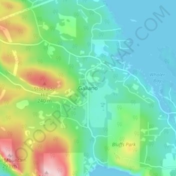
Nom : Carte topographique Galiano, altitude, relief.
Altitude moyenne : 82 m
Altitude minimum : 0 m
Altitude maximum : 300 m
Faire un don
Équipez-vous pour votre prochaine aventure :
En tant que Partenaire Amazon, ce site perçoit une commission sur les achats éligibles sans surcoût pour vous.
Autres cartes topographiques
Cliquez sur une carte pour visualiser sa topographie, son altitude et son relief.
Galiano Island
Canada > British Columbia > Capital Regional District > Southern Gulf Islands Electoral Area
Altitude moyenne : 24 m
Mayne Island
Canada > British Columbia > Capital Regional District > Southern Gulf Islands Electoral Area > Mayne
Altitude moyenne : 26 m
James Island
Canada > British Columbia > Capital Regional District > Southern Gulf Islands Electoral Area
James Island, one of British Columbia's Gulf Islands, lies in Haro Strait between Sidney Island and the coast of Vancouver Island near Sidney, British Columbia. James Island is approximately 2.4 km (1.5 mi) from the coast of Vancouver Island, and 145 km (90 mi) from Seattle, Washington. James Island has an…
Altitude moyenne : 8 m
Portland Island
Canada > British Columbia > Capital Regional District > Southern Gulf Islands Electoral Area
Altitude moyenne : 7 m
Faire un don
Équipez-vous pour votre prochaine aventure :
En tant que Partenaire Amazon, ce site perçoit une commission sur les achats éligibles sans surcoût pour vous.
North Pender Island
Canada > British Columbia > Capital Regional District > Southern Gulf Islands Electoral Area
Altitude moyenne : 23 m
Gulf Islands National Park Reserve
Canada > British Columbia > Capital Regional District > Southern Gulf Islands Electoral Area
Altitude moyenne : 57 m
Piers Island
Canada > British Columbia > Capital Regional District > Southern Gulf Islands Electoral Area
Altitude moyenne : 4 m
Saturna Island
Canada > British Columbia > Capital Regional District > Southern Gulf Islands Electoral Area
Altitude moyenne : 34 m
Faire un don
Équipez-vous pour votre prochaine aventure :
En tant que Partenaire Amazon, ce site perçoit une commission sur les achats éligibles sans surcoût pour vous.
Buck Lake
Canada > British Columbia > Capital Regional District > Southern Gulf Islands Electoral Area
Altitude moyenne : 58 m
Pym Island
Canada > British Columbia > Capital Regional District > Southern Gulf Islands Electoral Area
Altitude moyenne : 2 m
Haro Strait
Canada > British Columbia > Capital Regional District > Southern Gulf Islands Electoral Area
Altitude moyenne : 24 m
Sidney Island
Canada > British Columbia > Capital Regional District > Southern Gulf Islands Electoral Area
Sidney Island is one of the southern Gulf Islands located between the southwest coast of British Columbia, Canada and Vancouver Island, BC, near James Island. Sidney Island has an elevation of 77 metres (252 feet 8 inches) above mean sea level at its highest point. It is located across Sidney Channel, just…
Altitude moyenne : 7 m
Faire un don
Équipez-vous pour votre prochaine aventure :
En tant que Partenaire Amazon, ce site perçoit une commission sur les achats éligibles sans surcoût pour vous.
Mayne Island
Canada > British Columbia > Capital Regional District > Southern Gulf Islands Electoral Area > Mayne
Altitude moyenne : 26 m