
Faire un don
Équipez-vous pour votre prochaine aventure :
En tant que Partenaire Amazon, ce site perçoit une commission sur les achats éligibles sans surcoût pour vous.
Carte topographique Kings County
Cliquez sur la carte pour afficher l’altitude.
Faire un don
Équipez-vous pour votre prochaine aventure :
En tant que Partenaire Amazon, ce site perçoit une commission sur les achats éligibles sans surcoût pour vous.
À propos de cette carte
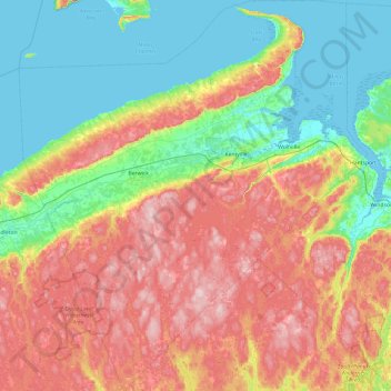
Nom : Carte topographique Kings County, altitude, relief.
Lieu : Kings County, Nova Scotia, Canada (44.66371 -65.02090 45.33905 -64.17259)
Altitude moyenne : 111 m
Altitude minimum : -2 m
Altitude maximum : 284 m
Faire un don
Équipez-vous pour votre prochaine aventure :
En tant que Partenaire Amazon, ce site perçoit une commission sur les achats éligibles sans surcoût pour vous.
Autres cartes topographiques
Cliquez sur une carte pour visualiser sa topographie, son altitude et son relief.
Annapolis Valley
Canada > Nova Scotia > Municipality of the County of Kings > Auburn
Altitude moyenne : 77 m
Faire un don
Équipez-vous pour votre prochaine aventure :
En tant que Partenaire Amazon, ce site perçoit une commission sur les achats éligibles sans surcoût pour vous.
Faire un don
Équipez-vous pour votre prochaine aventure :
En tant que Partenaire Amazon, ce site perçoit une commission sur les achats éligibles sans surcoût pour vous.
Mersey River
Canada > Nova Scotia > Queens County > Kejimkujik National Park of Canada
Altitude moyenne : 93 m
Faire un don
Équipez-vous pour votre prochaine aventure :
En tant que Partenaire Amazon, ce site perçoit une commission sur les achats éligibles sans surcoût pour vous.
Faire un don
Équipez-vous pour votre prochaine aventure :
En tant que Partenaire Amazon, ce site perçoit une commission sur les achats éligibles sans surcoût pour vous.
Cape Split
Canada > Nova Scotia > Queens County > Kejimkujik National Park of Canada
Altitude moyenne : 130 m
Faire un don
Équipez-vous pour votre prochaine aventure :
En tant que Partenaire Amazon, ce site perçoit une commission sur les achats éligibles sans surcoût pour vous.
Chignecto Isthmus
Canada > Nova Scotia > Municipality of the County of Cumberland > Fort Lawrence
Altitude moyenne : 14 m
Faire un don
Équipez-vous pour votre prochaine aventure :
En tant que Partenaire Amazon, ce site perçoit une commission sur les achats éligibles sans surcoût pour vous.
River Philip Centre
Canada > Nova Scotia > Municipality of the County of Cumberland
Altitude moyenne : 85 m
Faire un don
Équipez-vous pour votre prochaine aventure :
En tant que Partenaire Amazon, ce site perçoit une commission sur les achats éligibles sans surcoût pour vous.
Starrs Point
Canada > Nova Scotia > Municipality of the County of Kings > Port Williams
Altitude moyenne : 3 m
Gaspereau Mountain
Canada > Nova Scotia > Municipality of the County of Kings > Forest Hill
Altitude moyenne : 185 m
Faire un don
Équipez-vous pour votre prochaine aventure :
En tant que Partenaire Amazon, ce site perçoit une commission sur les achats éligibles sans surcoût pour vous.
White Hill
Canada > Nova Scotia > Cape Breton Highlands National Park > Cape Breton Highlands National Park
White Hill is a peak in the Cape Breton Highlands and is the highest elevation point in the province of Nova Scotia, Canada.
Altitude moyenne : 488 m
Faire un don
Équipez-vous pour votre prochaine aventure :
En tant que Partenaire Amazon, ce site perçoit une commission sur les achats éligibles sans surcoût pour vous.
Loon Lake Channel
Canada > Nova Scotia > Municipality of the County of Kings > Aylesford Lake
Altitude moyenne : 220 m
Faire un don
Équipez-vous pour votre prochaine aventure :
En tant que Partenaire Amazon, ce site perçoit une commission sur les achats éligibles sans surcoût pour vous.
Victoria Bridge
Canada > Nova Scotia > Cape Breton Regional Municipality > Upper Grand Mira
Altitude moyenne : 17 m
Faire un don
Équipez-vous pour votre prochaine aventure :
En tant que Partenaire Amazon, ce site perçoit une commission sur les achats éligibles sans surcoût pour vous.
Faire un don
Équipez-vous pour votre prochaine aventure :
En tant que Partenaire Amazon, ce site perçoit une commission sur les achats éligibles sans surcoût pour vous.
Eastern Shore District High School Park
Canada > Nova Scotia > Halifax County > Musquodoboit Harbour
Altitude moyenne : 24 m
Faire un don
Équipez-vous pour votre prochaine aventure :
En tant que Partenaire Amazon, ce site perçoit une commission sur les achats éligibles sans surcoût pour vous.
Gaspereau
Canada > Nova Scotia > Municipality of the County of Kings > Gaspereau
Altitude moyenne : 95 m
Faire un don
Équipez-vous pour votre prochaine aventure :
En tant que Partenaire Amazon, ce site perçoit une commission sur les achats éligibles sans surcoût pour vous.
North Mountain
Canada > Nova Scotia > Municipality of the County of Annapolis > Port Royal
Altitude moyenne : 134 m
Salmon River Road
Canada > Nova Scotia > Cape Breton Regional Municipality > Grand Mira North
Altitude moyenne : 18 m
Faire un don
Équipez-vous pour votre prochaine aventure :
En tant que Partenaire Amazon, ce site perçoit une commission sur les achats éligibles sans surcoût pour vous.
Mullins Point
Canada > Nova Scotia > Municipality of the County of Cumberland > North Wallace
Altitude moyenne : 2 m
Blue Sea Corner
Canada > Nova Scotia > Municipality of the County of Cumberland > Malagash Point
Altitude moyenne : 11 m
The Lookoff
Canada > Nova Scotia > Municipality of Victoria County > Forks Baddeck
Altitude moyenne : 301 m
Cape Split
Canada > Nova Scotia > Municipality of the County of Kings > Scots Bay
Altitude moyenne : 6 m
Faire un don
Équipez-vous pour votre prochaine aventure :
En tant que Partenaire Amazon, ce site perçoit une commission sur les achats éligibles sans surcoût pour vous.
Long Point Provincial Park
Canada > Nova Scotia > Municipality of the County of Inverness > Long Point
Altitude moyenne : 32 m
Faire un don
Équipez-vous pour votre prochaine aventure :
En tant que Partenaire Amazon, ce site perçoit une commission sur les achats éligibles sans surcoût pour vous.
Upper Kempt Head
Canada > Nova Scotia > Municipality of Victoria County > Kempt Head
Altitude moyenne : 20 m
Westchester Valley
Canada > Nova Scotia > Municipality of the County of Cumberland
Altitude moyenne : 194 m
Faire un don
Équipez-vous pour votre prochaine aventure :
En tant que Partenaire Amazon, ce site perçoit une commission sur les achats éligibles sans surcoût pour vous.
Frasertown
Canada > Nova Scotia > Municipality of the County of Annapolis > Princedale
Altitude moyenne : 138 m
Upper Glencoe
Canada > Nova Scotia > Municipality of the County of Inverness > Glencoe
Altitude moyenne : 181 m
Faire un don
Équipez-vous pour votre prochaine aventure :
En tant que Partenaire Amazon, ce site perçoit une commission sur les achats éligibles sans surcoût pour vous.
Shingle Lake
Canada > Nova Scotia > Guysborough District Municipality > Forest Hill
Altitude moyenne : 124 m
Faire un don
Équipez-vous pour votre prochaine aventure :
En tant que Partenaire Amazon, ce site perçoit une commission sur les achats éligibles sans surcoût pour vous.
Roundhill Lakes
Canada > Nova Scotia > Municipality of Victoria County > Cape Breton Highlands National Park
Altitude moyenne : 427 m
Cranberry Lake
Canada > Nova Scotia > Cape Breton Regional Municipality > Enon
Altitude moyenne : 103 m
Sporting Mountain
Canada > Nova Scotia > Municipality of the County of Richmond > River Bourgeois
Altitude moyenne : 59 m
Faire un don
Équipez-vous pour votre prochaine aventure :
En tant que Partenaire Amazon, ce site perçoit une commission sur les achats éligibles sans surcoût pour vous.
Boularderie
Canada > Nova Scotia > Municipality of Victoria County > Ross Ferry
Altitude moyenne : 50 m
Meat Cove
Canada > Nova Scotia > Municipality of the County of Inverness > Meat Cove
Altitude moyenne : 117 m
Faire un don
Équipez-vous pour votre prochaine aventure :
En tant que Partenaire Amazon, ce site perçoit une commission sur les achats éligibles sans surcoût pour vous.
Larry's River
Canada > Nova Scotia > Guysborough District Municipality > Larrys River
Altitude moyenne : 5 m
Centreville
Canada > Nova Scotia > Cape Breton Regional Municipality > Sydney Mines
Altitude moyenne : 12 m
Faire un don
Équipez-vous pour votre prochaine aventure :
En tant que Partenaire Amazon, ce site perçoit une commission sur les achats éligibles sans surcoût pour vous.
Garrets Lake
Canada > Nova Scotia > Municipality of the County of Richmond > Salmon River
Altitude moyenne : 48 m
Faire un don
Équipez-vous pour votre prochaine aventure :
En tant que Partenaire Amazon, ce site perçoit une commission sur les achats éligibles sans surcoût pour vous.
Glasgow Mountain
Canada > Nova Scotia > Municipality of the County of Cumberland > Diligent River
Altitude moyenne : 143 m
Comeau Point
Canada > Nova Scotia > Municipality of the County of Richmond > Alderney Point
Altitude moyenne : 11 m
Lansdowne Lake
Canada > Nova Scotia > Municipality of Pictou County > New Lairg
Altitude moyenne : 160 m
Two Rivers
Canada > Nova Scotia > Municipality of the County of Cumberland > Joggins
Altitude moyenne : 52 m
Faire un don
Équipez-vous pour votre prochaine aventure :
En tant que Partenaire Amazon, ce site perçoit une commission sur les achats éligibles sans surcoût pour vous.