
Faire un don
Équipez-vous pour votre prochaine aventure :
En tant que Partenaire Amazon, ce site perçoit une commission sur les achats éligibles sans surcoût pour vous.
Carte topographique Twatt
Cliquez sur la carte pour afficher l’altitude.
Faire un don
Équipez-vous pour votre prochaine aventure :
En tant que Partenaire Amazon, ce site perçoit une commission sur les achats éligibles sans surcoût pour vous.
À propos de cette carte
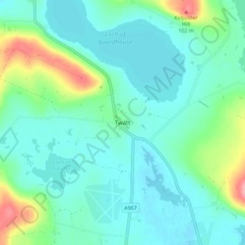
Nom : Carte topographique Twatt, altitude, relief.
Lieu : Twatt, Orkney Islands, Scotland, KW17 2LN, United Kingdom (59.08070 -3.29806 59.12070 -3.25806)
Altitude moyenne : 33 m
Altitude minimum : 11 m
Altitude maximum : 109 m
Faire un don
Équipez-vous pour votre prochaine aventure :
En tant que Partenaire Amazon, ce site perçoit une commission sur les achats éligibles sans surcoût pour vous.
Autres cartes topographiques
Cliquez sur une carte pour visualiser sa topographie, son altitude et son relief.
Orkney Islands
United Kingdom > Scotland > Orkney Islands
The southern group of islands surrounds Scapa Flow. Hoy, to the west, is the second largest of the Orkney Isles and Ward Hill at its northern end is the highest elevation in the archipelago. The Old Man of Hoy is a well-known seastack. Graemsay and Flotta are both linked by ferry to the Mainland and Hoy, and…
Altitude moyenne : 9 m
Sanday
United Kingdom > Scotland > Orkney Islands > Kettletoft
In the mid-17th century an annexe to Blaeu's Atlas Novus of Scotland recorded that Sanday's low lying topography meant that "shipwreck often occurs to those who sail there at night. The inhabitants of Sanday earnestly and often desire this to happen, so that they get a supply of material for fire from the…
Altitude moyenne : 2 m
Faire un don
Équipez-vous pour votre prochaine aventure :
En tant que Partenaire Amazon, ce site perçoit une commission sur les achats éligibles sans surcoût pour vous.
Faire un don
Équipez-vous pour votre prochaine aventure :
En tant que Partenaire Amazon, ce site perçoit une commission sur les achats éligibles sans surcoût pour vous.
Faire un don
Équipez-vous pour votre prochaine aventure :
En tant que Partenaire Amazon, ce site perçoit une commission sur les achats éligibles sans surcoût pour vous.
Faire un don
Équipez-vous pour votre prochaine aventure :
En tant que Partenaire Amazon, ce site perçoit une commission sur les achats éligibles sans surcoût pour vous.
South Ronaldsay
United Kingdom > Scotland > Orkney Islands
The cardinal points of the island are Ayre of Cara, by Churchill Barrier no. 4 (north), Grimness (east), Brough Ness, (south) and Hoxa Head, (west). The highest elevation is Ward Hill, which reaches 118 metres (387 ft). This name is common one in Orkney for the highest point on an island and comes from the…
Altitude moyenne : 12 m
Stronsay
United Kingdom > Scotland > Orkney Islands > Whitehall
Stronsay (/ˈstrɒnziː/) is an island in Orkney, Scotland. It is known as Orkney's 'Island of Bays', owing to an irregular shape with miles of coastline, with three large bays separated by two isthmuses: St Catherine's Bay to the west, the Bay of Holland to the south and Mill Bay to the east. Stronsay is…
Altitude moyenne : 4 m
Faire un don
Équipez-vous pour votre prochaine aventure :
En tant que Partenaire Amazon, ce site perçoit une commission sur les achats éligibles sans surcoût pour vous.
Faire un don
Équipez-vous pour votre prochaine aventure :
En tant que Partenaire Amazon, ce site perçoit une commission sur les achats éligibles sans surcoût pour vous.
Orkney Islands
United Kingdom > Scotland > Orkney Islands
The southern group of islands surrounds Scapa Flow. Hoy, to the west, is the second largest of the Orkney Isles and Ward Hill at its northern end is the highest elevation in the archipelago. The Old Man of Hoy is a well-known seastack. Graemsay and Flotta are both linked by ferry to the Mainland and Hoy, and…
Altitude moyenne : 9 m
Sanday
United Kingdom > Scotland > Orkney Islands > Kettletoft
In the mid-17th century an annexe to Blaeu's Atlas Novus of Scotland recorded that Sanday's low lying topography meant that "shipwreck often occurs to those who sail there at night. The inhabitants of Sanday earnestly and often desire this to happen, so that they get a supply of material for fire from the…
Altitude moyenne : 2 m
Faire un don
Équipez-vous pour votre prochaine aventure :
En tant que Partenaire Amazon, ce site perçoit une commission sur les achats éligibles sans surcoût pour vous.