
Faire un don
Équipez-vous pour votre prochaine aventure :
En tant que Partenaire Amazon, ce site perçoit une commission sur les achats éligibles sans surcoût pour vous.
Carte topographique San Marcos
Cliquez sur la carte pour afficher l’altitude.
Faire un don
Équipez-vous pour votre prochaine aventure :
En tant que Partenaire Amazon, ce site perçoit une commission sur les achats éligibles sans surcoût pour vous.
À propos de cette carte
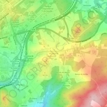
Nom : Carte topographique San Marcos, altitude, relief.
Altitude moyenne : 332 m
Altitude minimum : 213 m
Altitude maximum : 477 m
Faire un don
Équipez-vous pour votre prochaine aventure :
En tant que Partenaire Amazon, ce site perçoit une commission sur les achats éligibles sans surcoût pour vous.
Autres cartes topographiques
Cliquez sur une carte pour visualiser sa topographie, son altitude et son relief.
Santiago de Compostela
Spain > Galicia > Santiago > Santiago de Compostela
According to a medieval legend, the remains of the apostle James, son of Zebedee were brought to Galicia for burial, where they were lost. Eight hundred years later the light of a bright star guided a shepherd, Pelagius the Hermit, who was watching his flock at night to the burial site in Santiago de…
Altitude moyenne : 260 m
O Campón do Milladoiro
Spain > Galicia > Santiago > Santiago de Compostela > As Moas de Arriba
Altitude moyenne : 241 m