
Carte topographique Arab
Carte interactive
Cliquez sur la carte pour afficher l’altitude.
À propos de cette carte
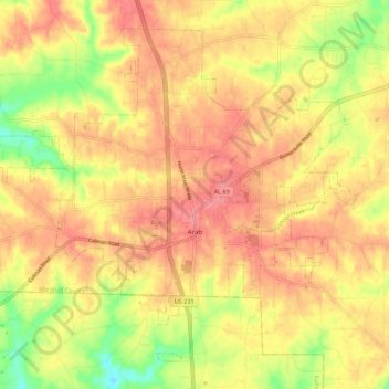
Nom : Carte topographique Arab, altitude, relief.
Lieu : Arab, Marshall County, Alabama, 35016, United States (34.28777 -86.56015 34.36571 -86.45000)
Altitude moyenne : 314 m
Altitude minimum : 266 m
Altitude maximum : 343 m
Arab is located at an elevation of 1,100 feet (340 m) on top of Brindlee Mountain, near the southwest end of the Appalachian Plateau. The city is primarily in southern Marshall County; a small portion extends south into Cullman County. U.S. Route 231 runs north-to-south through Arab, and State Route 69 runs east-to-west, through the city's business district. US 231 leads north 31 miles (50 km) to Huntsville and south 32 miles (51 km) to Oneonta, while SR 69 leads east 13 miles (21 km) to Guntersville and southwest 23 miles (37 km) to Cullman.
Autres cartes topographiques
Cliquez sur une carte pour visualiser sa topographie, son altitude et son relief.
Guntersville
United States > Alabama > Marshall County
Guntersville, Marshall County, Alabama, 35976, United States
Altitude moyenne : 242 m
Needmore
United States > Alabama > Marshall County
Needmore, Marshall County, Alabama, United States
Altitude moyenne : 294 m
Albertville
United States > Alabama > Marshall County
Albertville, Marshall County, Alabama, 35950, United States
Altitude moyenne : 309 m
Bucksnort
United States > Alabama > Marshall County
Bucksnort, Marshall County, Alabama, 35747, United States
Altitude moyenne : 289 m
Union Grove
United States > Alabama > Marshall County > Union Grove
Union Grove, Marshall County, Alabama, United States
Altitude moyenne : 300 m
Lake Guntersville State Park
United States > Alabama > Marshall County > Guntersville
Lake Guntersville State Park, Guntersville, Marshall County, Alabama, United States
Altitude moyenne : 242 m
Grant
United States > Alabama > Marshall County
Grant, Marshall County, Alabama, 35847, United States
Altitude moyenne : 300 m
Shoal Creek
United States > Alabama > Marshall County > Arab
Shoal Creek, Arab, Marshall County, Alabama, 35016, United States
Altitude moyenne : 327 m
Lindsay Lane
United States > Alabama > Marshall County > Guntersville
Lindsay Lane, Guntersville, Marshall County, Alabama, 35976, United States
Altitude moyenne : 249 m
Union Grove
United States > Alabama > Marshall County
Union Grove, Marshall County, Alabama, United States
Altitude moyenne : 299 m
Boaz
United States > Alabama > Marshall County
Boaz, Marshall County, Alabama, 35957, United States
Altitude moyenne : 320 m
Wyeth City
United States > Alabama > Marshall County > Guntersville > Wyeth City
Wyeth City, Guntersville, Marshall County, Alabama, 35976, United States
Altitude moyenne : 230 m
Guntersville
United States > Alabama > Marshall County > Guntersville
Guntersville, Marshall County, Alabama, 35976, United States
Altitude moyenne : 208 m
Bob Mountain
United States > Alabama > Marshall County
Bob Mountain, Marshall County, Alabama, United States
Altitude moyenne : 206 m