
Carte topographique Mühlberg
Carte interactive
Cliquez sur la carte pour afficher l’altitude.
À propos de cette carte
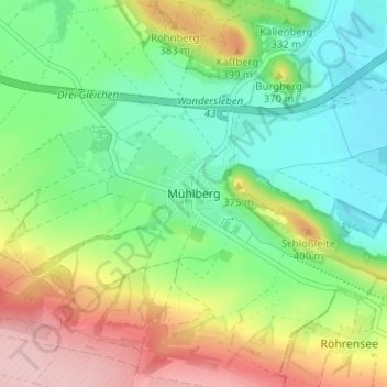
Nom : Carte topographique Mühlberg, altitude, relief.
Altitude moyenne : 323 m
Altitude minimum : 255 m
Altitude maximum : 441 m
Autres cartes topographiques
Cliquez sur une carte pour visualiser sa topographie, son altitude et son relief.
Gotha
Duitsland > Thüringen > Landkreis Gotha
Gotha, Landkreis Gotha, Thüringen, Duitsland
Altitude moyenne : 320 m