
Carte topographique Gotha
Carte interactive
Cliquez sur la carte pour afficher l’altitude.
À propos de cette carte
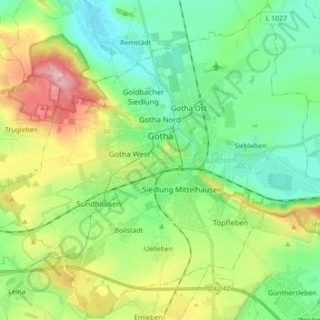
Nom : Carte topographique Gotha, altitude, relief.
Lieu : Gotha, Landkreis Gotha, Thüringen, Duitsland (50.89218 10.62230 50.99128 10.78184)
Altitude moyenne : 320 m
Altitude minimum : 263 m
Altitude maximum : 442 m
Autres cartes topographiques
Cliquez sur une carte pour visualiser sa topographie, son altitude et son relief.
Mühlberg
Duitsland > Thüringen > Landkreis Gotha
Mühlberg, Drei Gleichen, Landkreis Gotha, Thüringen, 99869, Duitsland
Altitude moyenne : 323 m