
Faire un don
Équipez-vous pour votre prochaine aventure :
En tant que Partenaire Amazon, ce site perçoit une commission sur les achats éligibles sans surcoût pour vous.
Carte topographique lac Seul
Cliquez sur la carte pour afficher l’altitude.
Faire un don
Équipez-vous pour votre prochaine aventure :
En tant que Partenaire Amazon, ce site perçoit une commission sur les achats éligibles sans surcoût pour vous.
lac Seul
Lac Seul is a large, crescent shaped reservoir in Kenora District, northwestern Ontario, Canada. It is approximately 241 km (150 mi) long. It has a maximum (regulated) depth of 47.2 m, with a surface elevation of 357 m above sea level. Its level is raised in the summer and then drawn down in the winter months to reach points of as low as 16 feet below the maximum level. It is the second largest body of water entirely within the province of Ontario (Lake Nipigon being first). The lake consists of open water bays, narrow channels, and islands. It is a relatively shallow lake with many rock shoals. This provides a good habitat for walleye (also known as "yellow pickerel") and northern pike as well as yellow perch. During the Lac Seul project of 1968-1972 no muskelunge were noted in the catches of research nets set over those years. Significant numbers of whitefish, tullibee, burbot and cisco were noted as well although they infrequently were noted in the sport fishery. Lac Seul is noted for offering some of the best fishing in Ontario.
Faire un don
Équipez-vous pour votre prochaine aventure :
En tant que Partenaire Amazon, ce site perçoit une commission sur les achats éligibles sans surcoût pour vous.
À propos de cette carte
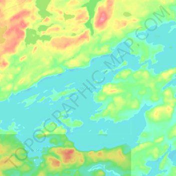
Nom : Carte topographique lac Seul, altitude, relief.
Altitude moyenne : 374 m
Altitude minimum : 351 m
Altitude maximum : 431 m
Faire un don
Équipez-vous pour votre prochaine aventure :
En tant que Partenaire Amazon, ce site perçoit une commission sur les achats éligibles sans surcoût pour vous.
Autres cartes topographiques
Cliquez sur une carte pour visualiser sa topographie, son altitude et son relief.
Burditt Lake
Canada > Ontario > Kenora District > Unorganized Kenora District
Altitude moyenne : 367 m
Faire un don
Équipez-vous pour votre prochaine aventure :
En tant que Partenaire Amazon, ce site perçoit une commission sur les achats éligibles sans surcoût pour vous.
Cardinal (Lac) Lake
Canada > Ontario > Kenora District > Unorganized Kenora District
Altitude moyenne : 392 m
Hudson Bay Lowlands
Canada > Ontario > Kenora District > Unorganized Kenora District
Altitude moyenne : 17 m
Carroll Lake
Canada > Ontario > Kenora District > Unorganized Kenora District
Altitude moyenne : 338 m
Faire un don
Équipez-vous pour votre prochaine aventure :
En tant que Partenaire Amazon, ce site perçoit une commission sur les achats éligibles sans surcoût pour vous.
Granite Lake
Canada > Ontario > Kenora District > Unorganized Kenora District
Altitude moyenne : 355 m
Faire un don
Équipez-vous pour votre prochaine aventure :
En tant que Partenaire Amazon, ce site perçoit une commission sur les achats éligibles sans surcoût pour vous.
Gordon Island
Canada > Ontario > Kenora District > Unorganized Kenora District
Altitude moyenne : 349 m
Faire un don
Équipez-vous pour votre prochaine aventure :
En tant que Partenaire Amazon, ce site perçoit une commission sur les achats éligibles sans surcoût pour vous.
Grindstone Lake
Canada > Ontario > Kenora District > Unorganized Kenora District
Altitude moyenne : 371 m
Faire un don
Équipez-vous pour votre prochaine aventure :
En tant que Partenaire Amazon, ce site perçoit une commission sur les achats éligibles sans surcoût pour vous.
Warwick Lake
Canada > Ontario > Kenora District > Unorganized Kenora District
Altitude moyenne : 341 m
Slate Islands
Canada > Ontario > Kenora District > Unorganized Kenora District
Altitude moyenne : 322 m
Faire un don
Équipez-vous pour votre prochaine aventure :
En tant que Partenaire Amazon, ce site perçoit une commission sur les achats éligibles sans surcoût pour vous.
Mackey Island
Canada > Ontario > Kenora District > Unorganized Kenora District
Altitude moyenne : 336 m
Big Island Lake
Canada > Ontario > Kenora District > Unorganized Kenora District
Altitude moyenne : 430 m
Faire un don
Équipez-vous pour votre prochaine aventure :
En tant que Partenaire Amazon, ce site perçoit une commission sur les achats éligibles sans surcoût pour vous.
Nine Mile Lake
Canada > Ontario > Kenora District > Unorganized Kenora District
Altitude moyenne : 413 m
Faire un don
Équipez-vous pour votre prochaine aventure :
En tant que Partenaire Amazon, ce site perçoit une commission sur les achats éligibles sans surcoût pour vous.
Chisholm Island
Canada > Ontario > Kenora District > Unorganized Kenora District
Altitude moyenne : 323 m
Clearwater Bay
Canada > Ontario > Kenora District > Unorganized Kenora District
Altitude moyenne : 334 m
Faire un don
Équipez-vous pour votre prochaine aventure :
En tant que Partenaire Amazon, ce site perçoit une commission sur les achats éligibles sans surcoût pour vous.
Muskeg River
Canada > Ontario > Kenora District > Unorganized Kenora District
Altitude moyenne : 357 m
Muskeg River
Canada > Ontario > Kenora District > Unorganized Kenora District
Altitude moyenne : 363 m
Dingwall Island
Canada > Ontario > Kenora District > Unorganized Kenora District
Altitude moyenne : 325 m
Faire un don
Équipez-vous pour votre prochaine aventure :
En tant que Partenaire Amazon, ce site perçoit une commission sur les achats éligibles sans surcoût pour vous.
Little Boulder Lake
Canada > Ontario > Kenora District > Unorganized Kenora District
Altitude moyenne : 359 m
Cameron Island
Canada > Ontario > Kenora District > Unorganized Kenora District
Altitude moyenne : 338 m
Faire un don
Équipez-vous pour votre prochaine aventure :
En tant que Partenaire Amazon, ce site perçoit une commission sur les achats éligibles sans surcoût pour vous.