
Faire un don
Équipez-vous pour votre prochaine aventure :
En tant que Partenaire Amazon, ce site perçoit une commission sur les achats éligibles sans surcoût pour vous.
Carte topographique Pelican Narrows
Cliquez sur la carte pour afficher l’altitude.
Faire un don
Équipez-vous pour votre prochaine aventure :
En tant que Partenaire Amazon, ce site perçoit une commission sur les achats éligibles sans surcoût pour vous.
À propos de cette carte
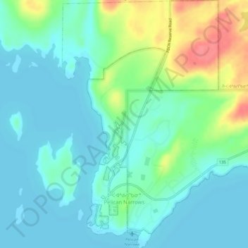
Nom : Carte topographique Pelican Narrows, altitude, relief.
Lieu : Pelican Narrows, Division No. 18, Saskatchewan, Canada (55.16419 -102.94929 55.19373 -102.91669)
Altitude moyenne : 328 m
Altitude minimum : 310 m
Altitude maximum : 380 m
Faire un don
Équipez-vous pour votre prochaine aventure :
En tant que Partenaire Amazon, ce site perçoit une commission sur les achats éligibles sans surcoût pour vous.
Autres cartes topographiques
Cliquez sur une carte pour visualiser sa topographie, son altitude et son relief.
McClean Lake
Canada > Saskatchewan > Division No. 18 > Unorganized Division No. 18
Altitude moyenne : 440 m
Faire un don
Équipez-vous pour votre prochaine aventure :
En tant que Partenaire Amazon, ce site perçoit une commission sur les achats éligibles sans surcoût pour vous.
Clearwater River
Canada > Saskatchewan > Division No. 18 > Unorganized Division No. 18
From Broach Lake at an elevation of 460 metres (1,510 ft) above sea level, the Clearwater drops about 150 metres (490 ft) to the confluence at Fort McMurray. Its waters eventually reach the Arctic Ocean via the Athabasca and Mackenzie Rivers. Tributaries of the Clearwater River include Descharme River and…
Altitude moyenne : 450 m
Sipanok Channel
Canada > Saskatchewan > Division No. 18 > Unorganized Division No. 18
Altitude moyenne : 277 m
Faire un don
Équipez-vous pour votre prochaine aventure :
En tant que Partenaire Amazon, ce site perçoit une commission sur les achats éligibles sans surcoût pour vous.