
Faire un don
Équipez-vous pour votre prochaine aventure :
En tant que Partenaire Amazon, ce site perçoit une commission sur les achats éligibles sans surcoût pour vous.
Carte topographique Sestao
Cliquez sur la carte pour afficher l’altitude.
Faire un don
Équipez-vous pour votre prochaine aventure :
En tant que Partenaire Amazon, ce site perçoit une commission sur les achats éligibles sans surcoût pour vous.
Sestao
The growth of the town of Sestao is limited by the lack of developable land and severely limited by natural and artificial barriers. For this reason, it has reached a highly densified town with a network of small open spaces. Historically, The grew of the population was a consequence of the development of the industry, and not the industry a consequence of the human presence in the area. This defines the DNA of Sestao. It is a settlement that is born exclusively by the implantation of the heavy industry. Consumption and land distribution is based on the industry (now there is more floor dedicated to industrial than residential uses) and these industrial areas are located in the best situations the city. The margin facing the estuary is colonized exclusively for industry, and the least quality areas (up to sixty meters of altitude) is intended to construction of workers' housing.
Faire un don
Équipez-vous pour votre prochaine aventure :
En tant que Partenaire Amazon, ce site perçoit une commission sur les achats éligibles sans surcoût pour vous.
À propos de cette carte
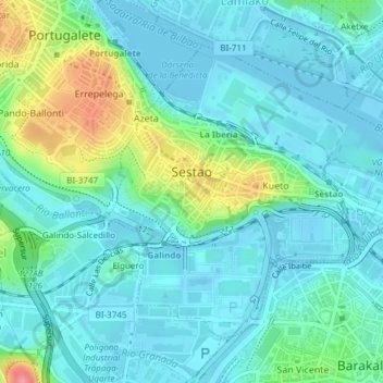
Nom : Carte topographique Sestao, altitude, relief.
Altitude moyenne : 21 m
Altitude minimum : -3 m
Altitude maximum : 94 m
Faire un don
Équipez-vous pour votre prochaine aventure :
En tant que Partenaire Amazon, ce site perçoit une commission sur les achats éligibles sans surcoût pour vous.
Autres cartes topographiques
Cliquez sur une carte pour visualiser sa topographie, son altitude et son relief.
Gebara
Spain > Autonomous Community of the Basque Country > Arabako lautada/Llanada Alavesa
Altitude moyenne : 574 m
Marabi
Spain > Autonomous Community of the Basque Country > Amorebieta-Etxano
Altitude moyenne : 161 m
Faire un don
Équipez-vous pour votre prochaine aventure :
En tant que Partenaire Amazon, ce site perçoit une commission sur les achats éligibles sans surcoût pour vous.
Karakate
Spain > Autonomous Community of the Basque Country > Debabarrena > Soraluze
Altitude moyenne : 366 m
Faire un don
Équipez-vous pour votre prochaine aventure :
En tant que Partenaire Amazon, ce site perçoit une commission sur les achats éligibles sans surcoût pour vous.
Bujal
Spain > Autonomous Community of the Basque Country > Añanako kuadrilla > Berantevilla
Altitude moyenne : 535 m
Araneta
Spain > Autonomous Community of the Basque Country > Gasteizko kuadrilla/Cuadrilla de Vitoria > Vitoria-Gasteiz > Bolívar
Altitude moyenne : 625 m
Soil
Spain > Autonomous Community of the Basque Country > Montaña Alavesa/Arabako Mendialdea
Altitude moyenne : 898 m
Faire un don
Équipez-vous pour votre prochaine aventure :
En tant que Partenaire Amazon, ce site perçoit une commission sur les achats éligibles sans surcoût pour vous.
Makola
Spain > Autonomous Community of the Basque Country > Urola-Kosta > Azkoitia
Altitude moyenne : 515 m
Fuente Oneri
Spain > Autonomous Community of the Basque Country > Arabako lautada/Llanada Alavesa > Agurain/Salvatierra
Altitude moyenne : 681 m
Iruka
Spain > Autonomous Community of the Basque Country > Debabarrena > Eibar
Altitude moyenne : 425 m
Faire un don
Équipez-vous pour votre prochaine aventure :
En tant que Partenaire Amazon, ce site perçoit une commission sur les achats éligibles sans surcoût pour vous.
Torrea
Spain > Autonomous Community of the Basque Country > Debabarrena > Eibar
Altitude moyenne : 398 m
Flysch
Spain > Autonomous Community of the Basque Country > Urola-Kosta > Zumaia
Altitude moyenne : 27 m
Barinatxe - La Salvaje
Spain > Autonomous Community of the Basque Country > Sopela
Altitude moyenne : 26 m
Lore-Toki
Spain > Autonomous Community of the Basque Country > Arabako Errioxa/Rioja Alavesa > Labastida/Bastida
Altitude moyenne : 499 m
Faire un don
Équipez-vous pour votre prochaine aventure :
En tant que Partenaire Amazon, ce site perçoit une commission sur les achats éligibles sans surcoût pour vous.
Trevilla
Spain > Autonomous Community of the Basque Country > Karrantza Harana/Valle de Carranza > Concha
Altitude moyenne : 333 m
Faire un don
Équipez-vous pour votre prochaine aventure :
En tant que Partenaire Amazon, ce site perçoit une commission sur les achats éligibles sans surcoût pour vous.
Floreaga
Spain > Autonomous Community of the Basque Country > Urola-Kosta > Azkoitia
Altitude moyenne : 266 m
Hondarribiko hondartza
Spain > Autonomous Community of the Basque Country > Gipuzkoako Bidasoa > Hondarribia
Altitude moyenne : 31 m
Faire un don
Équipez-vous pour votre prochaine aventure :
En tant que Partenaire Amazon, ce site perçoit une commission sur les achats éligibles sans surcoût pour vous.
Gorbeia
Spain > Autonomous Community of the Basque Country > Gorbeialdea > Zeanuri
Altitude moyenne : 1 189 m
Santa Barbara
Spain > Autonomous Community of the Basque Country > Hernani > Sorgintxulo
Altitude moyenne : 68 m
Monterredondo
Spain > Autonomous Community of the Basque Country > Añanako kuadrilla/Cuadrilla de Añana
Altitude moyenne : 875 m
Faire un don
Équipez-vous pour votre prochaine aventure :
En tant que Partenaire Amazon, ce site perçoit une commission sur les achats éligibles sans surcoût pour vous.
Oñati
Spain > Autonomous Community of the Basque Country > Debagoiena > Oñati
Altitude moyenne : 488 m
Plaza de Larrazábal
Spain > Autonomous Community of the Basque Country > Bilbao
Altitude moyenne : 101 m
Gautegiz Arteaga
Spain > Autonomous Community of the Basque Country > Gautegiz Arteaga > Gautegiz Arteaga
Altitude moyenne : 104 m
Faire un don
Équipez-vous pour votre prochaine aventure :
En tant que Partenaire Amazon, ce site perçoit une commission sur les achats éligibles sans surcoût pour vous.
Zaldibar
Spain > Autonomous Community of the Basque Country > Zaldibar > Zaldibar
Altitude moyenne : 305 m
Soil
Spain > Autonomous Community of the Basque Country > Montaña Alavesa/Arabako Mendialdea
Altitude moyenne : 898 m