
Faire un don
Équipez-vous pour votre prochaine aventure :
En tant que Partenaire Amazon, ce site perçoit une commission sur les achats éligibles sans surcoût pour vous.
Carte topographique Wyoming
Cliquez sur la carte pour afficher l’altitude.
Faire un don
Équipez-vous pour votre prochaine aventure :
En tant que Partenaire Amazon, ce site perçoit une commission sur les achats éligibles sans surcoût pour vous.
À propos de cette carte
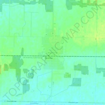
Nom : Carte topographique Wyoming, altitude, relief.
Altitude moyenne : 216 m
Altitude minimum : 209 m
Altitude maximum : 223 m
Faire un don
Équipez-vous pour votre prochaine aventure :
En tant que Partenaire Amazon, ce site perçoit une commission sur les achats éligibles sans surcoût pour vous.
Autres cartes topographiques
Cliquez sur une carte pour visualiser sa topographie, son altitude et son relief.
Sarnia
Canada > Ontario > Lambton County
Sarnia is located on the eastern shore of Lake Huron at its extreme southern point, where it flows into the St. Clair River. Most of the surrounding area is flat, and the elevation ranges from 169 metres (554 ft) and 281 metres (922 ft) above sea level. The soil mostly comprises clay. Despite this high…
Altitude moyenne : 186 m
Faire un don
Équipez-vous pour votre prochaine aventure :
En tant que Partenaire Amazon, ce site perçoit une commission sur les achats éligibles sans surcoût pour vous.
Johnston Channel
Canada > Ontario > Lambton County
The creek begins at the right bank of the Chenail Ecarté (The Snye) at an elevation of 175 metres (574 ft), west of the community of Wallaceburg. It meanders south, then turns southwest, and reaches its mouth at Johnston Bay on Lake St. Clair, at an elevation of 175 metres (574 ft). Lake St. Clair flows via…
Altitude moyenne : 176 m
Faire un don
Équipez-vous pour votre prochaine aventure :
En tant que Partenaire Amazon, ce site perçoit une commission sur les achats éligibles sans surcoût pour vous.
Faire un don
Équipez-vous pour votre prochaine aventure :
En tant que Partenaire Amazon, ce site perçoit une commission sur les achats éligibles sans surcoût pour vous.
Sarnia
Canada > Ontario > Lambton County
Sarnia is located on the eastern shore of Lake Huron at its extreme southern point, where it flows into the St. Clair River. Most of the surrounding area is flat, and the elevation ranges from 169 to 281 m (554 to 922 ft) above sea level. The soil mainly comprises clay. Despite this high percentage of clay,…
Altitude moyenne : 186 m
Faire un don
Équipez-vous pour votre prochaine aventure :
En tant que Partenaire Amazon, ce site perçoit une commission sur les achats éligibles sans surcoût pour vous.
Sarnia
Canada > Ontario > Lambton County
Sarnia is located on the eastern shore of Lake Huron at its extreme southern point, where it flows into the St. Clair River. Most of the surrounding area is flat, and the elevation ranges from 169 to 281 m (554 to 922 ft) above sea level. The soil mainly comprises clay. Despite this high percentage of clay,…
Altitude moyenne : 186 m