
Carte topographique Ohio River
Carte interactive
Cliquez sur la carte pour afficher l’altitude.
À propos de cette carte
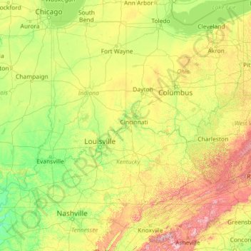
Nom : Carte topographique Ohio River, altitude, relief.
Lieu : Ohio River, United States (36.98350 -89.17727 40.69668 -80.01712)
Altitude moyenne : 293 m
Altitude minimum : 79 m
Altitude maximum : 1 945 m
The river became a primary transportation route for pioneers during the westward expansion of the early U.S. The lower Ohio River just below Louisville was obstructed by rapids known as the Falls of the Ohio where the elevation falls 26 feet (7.9 m) in 2 miles (3.2 km) restricting larger commercial navigation, although in the 18th and early 19th century its three deepest channels could be traversed by a wide variety of craft then in use. In 1830, the Louisville and Portland Canal (now the McAlpine Locks and Dam) bypassed the rapids, allowing even larger commercial and modern navigation from the Forks of the Ohio at Pittsburgh to the Port of New Orleans at the mouth of the Mississippi on the Gulf of Mexico. Since the "canalization" of the river in 1929, the Ohio has not been a natural free-flowing river; today, it is divided into 21 discrete pools or reservoirs by 20 locks and dams for navigation and power generation.
Autres cartes topographiques
Cliquez sur une carte pour visualiser sa topographie, son altitude et son relief.
Spokane
United States > Washington > Spokane County
Spokane, Spokane County, Washington, United States
Altitude moyenne : 655 m
College Station
United States > Texas > Brazos County
College Station, Brazos County, Texas, United States
Altitude moyenne : 87 m
Brooklyn
United States > New York > New York
Brooklyn, Kings County, New York, United States
Altitude moyenne : 9 m
Hillsborough County
Hillsborough County, Florida, United States
Altitude moyenne : 20 m
Charlotte County
Charlotte County, Florida, United States
Altitude moyenne : 10 m
Black Hills
United States > South Dakota > Pennington County
Black Hills, Pennington County, South Dakota, United States
Altitude moyenne : 1 894 m
Chula Vista
United States > California > San Diego County
Chula Vista, San Diego County, California, United States
Altitude moyenne : 42 m
Arlington
United States > Massachusetts > Middlesex County
Arlington, Middlesex County, Massachusetts, United States
Altitude moyenne : 35 m
Montgomery County
Montgomery County, Texas, United States
Altitude moyenne : 69 m
Hunterdon County
Hunterdon County, New Jersey, United States
Altitude moyenne : 120 m
Fairfax County
Fairfax County, Virginia, United States
Altitude moyenne : 75 m
Lexington
United States > Kentucky > Lexington
Lexington, Fayette County, Kentucky, 40508, United States
Altitude moyenne : 285 m
Fernandina Beach
United States > Florida > Nassau County
Fernandina Beach, Nassau County, Florida, 32035, United States
Altitude moyenne : 2 m
Greenwich
United States > Connecticut > Western Connecticut Planning Region
Greenwich, Western Connecticut Planning Region, Connecticut, United States
Altitude moyenne : 57 m
Madison
United States > Wisconsin > Dane County
Madison, Dane County, Wisconsin, United States
Altitude moyenne : 284 m
Houston
United States > Texas > Harris County
Houston, Harris County, Texas, United States
Altitude moyenne : 25 m
New Orleans
United States > Louisiana > Orleans Parish
New Orleans, Orleans Parish, Louisiana, United States
Altitude moyenne : 1 m
Sacramento
United States > California > Sacramento County
Sacramento, Sacramento County, California, United States
Altitude moyenne : 10 m
Fort Worth
United States > Texas > Tarrant County
Fort Worth, Tarrant County, Texas, United States
Altitude moyenne : 212 m
Miami-Dade County
Miami-Dade County, Florida, United States
Altitude moyenne : 3 m