
Carte topographique Mawlong
Carte interactive
Cliquez sur la carte pour afficher l’altitude.
À propos de cette carte
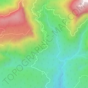
Nom : Carte topographique Mawlong, altitude, relief.
Altitude moyenne : 470 m
Altitude minimum : 86 m
Altitude maximum : 1 129 m
Autres cartes topographiques
Cliquez sur une carte pour visualiser sa topographie, son altitude et son relief.
Cherrapunji (Sohra)
India > Meghalaya > Shella Bholaganj > Cherrapunji (Sohra)
Cherrapunji (Sohra), Shella Bholaganj, East Khasi Hills, Meghalaya, 793108, India
Altitude moyenne : 1 248 m