
Faire un don
Équipez-vous pour votre prochaine aventure :
En tant que Partenaire Amazon, ce site perçoit une commission sur les achats éligibles sans surcoût pour vous.
Carte topographique Santurtzi
Cliquez sur la carte pour afficher l’altitude.
Faire un don
Équipez-vous pour votre prochaine aventure :
En tant que Partenaire Amazon, ce site perçoit une commission sur les achats éligibles sans surcoût pour vous.
Santurtzi
Santurtzi has a very rough orography although excluding Mount Serantes (452m) - one of its most symbolic topographic elements, it is not at high altitude, the significant heights being spurs of the Serantes (Serandi): The Mallet (245m) and the Fortified heights (123 and 106m). Its relief is within the north flank of the anticline of Biscay. It is a relief of a structural type corresponding to a series of materials of the Cretaceous period (limestone) throughout Punta Lucero-Serantes smoothly inclined towards the Estuary of Bilbao.
Faire un don
Équipez-vous pour votre prochaine aventure :
En tant que Partenaire Amazon, ce site perçoit une commission sur les achats éligibles sans surcoût pour vous.
À propos de cette carte
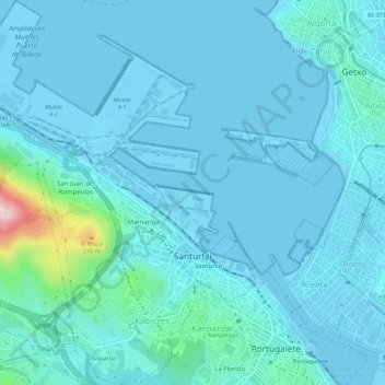
Nom : Carte topographique Santurtzi, altitude, relief.
Altitude moyenne : 34 m
Altitude minimum : -3 m
Altitude maximum : 360 m
Faire un don
Équipez-vous pour votre prochaine aventure :
En tant que Partenaire Amazon, ce site perçoit une commission sur les achats éligibles sans surcoût pour vous.