
Carte topographique Peace River
Carte interactive
Cliquez sur la carte pour afficher l’altitude.
À propos de cette carte
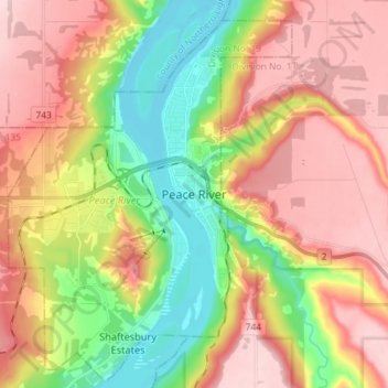
Nom : Carte topographique Peace River, altitude, relief.
Lieu : Peace River, Alberta, T8S 1P7, Canada (56.19371 -117.33108 56.27371 -117.25108)
Altitude moyenne : 433 m
Altitude minimum : 308 m
Altitude maximum : 551 m
Physiographically, the Town of Peace River lies within the Peace River Formation, a stratigraphical unit of middle Albian age in the Western Canadian Sedimentary Basin. The area developed on sediments of the former lake bottom of Glacial Lake Peace, which covered most of the areas in the region that were below 610 m in elevation.