
Carte topographique Saint John
Carte interactive
Cliquez sur la carte pour afficher l’altitude.
À propos de cette carte
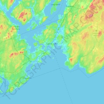
Nom : Carte topographique Saint John, altitude, relief.
Lieu : Saint John, Saint John County, New Brunswick, Canada (45.13325 -66.24562 45.37693 -65.83886)
Altitude moyenne : 38 m
Altitude minimum : -7 m
Altitude maximum : 226 m
The topography surrounding Saint John is hilly; a result of the influence of two coastal mountain ranges which run along the Bay of Fundy – the St. Croix Highlands and the Caledonia Highlands. The soil throughout the region is extremely rocky with frequent granite outcrops. The coastal plain hosts numerous freshwater lakes in the eastern, western and northern parts of the city.
Autres cartes topographiques
Cliquez sur une carte pour visualiser sa topographie, son altitude et son relief.
Drury Cove
Canada > New Brunswick > Saint John County > Saint John
Drury Cove, Saint John, Saint John County, New Brunswick, E2K 5K7, Canada
Altitude moyenne : 24 m
Tynemouth Creek
Canada > New Brunswick > Saint John County
Tynemouth Creek, Saint Martins Parish, Saint John County, New Brunswick, Canada
Altitude moyenne : 32 m
Little River
Canada > New Brunswick > Saint John County > Saint John
Little River, Saint John, Saint John County, New Brunswick, E2J 1N8, Canada
Altitude moyenne : 9 m
Lorneville
Canada > New Brunswick > Saint John County > Saint John > Lorneville
Lorneville, Saint John, Saint John County, New Brunswick, E2M 7G6, Canada
Altitude moyenne : 18 m