
Carte topographique Pickering
Cliquez sur la carte pour afficher l’altitude.
Pickering
The city covers an area of 231 square kilometres (89 sq mi) with an elevation of 89 metres (292 ft).
À propos de cette carte
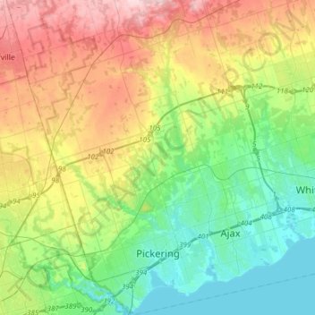
Nom : Carte topographique Pickering, altitude, relief.
Lieu : Pickering, Durham Region, Golden Horseshoe, Ontario, Canada (43.79307 -79.22004 44.01076 -79.00859)
Altitude moyenne : 170 m
Altitude minimum : 72 m
Altitude maximum : 351 m
Autres cartes topographiques
Cliquez sur une carte pour visualiser sa topographie, son altitude et son relief.
Darlington Provincial Park
Canada > Ontario > Durham Region > Clarington
Darlington Provincial Park is a provincial park in Ontario, Canada. It is located just south of Highway 401 in the city of Bowmanville. A small park, the topography is dominated by gentle hills formed by a terminal moraine deposited by glaciers at the end of the last Ice Age. The park borders on the northern…
Altitude moyenne : 84 m