Géolocaliser

Carte topographique Gibaja

Cliquez sur la carte pour afficher l’altitude.

À propos de cette carte

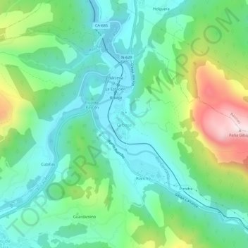
Nom : Carte topographique Gibaja, altitude, relief.

Lieu : Gibaja, Ramales de la Victoria, Cantabria, 39809, Spain (43.25679 -3.45642 43.29679 -3.41642)

Altitude moyenne : 212 m

Altitude minimum : 36 m

Altitude maximum : 663 m

Autres cartes topographiques

Cliquez sur une carte pour visualiser sa topographie, son altitude et son relief.

Polanco

Spain > Cantabria

Altitude moyenne : 54 m

Polanco

Spain > Cantabria

Altitude moyenne : 54 m

Comillas

Spain > Cantabria

Altitude moyenne : 84 m

Polanco

Spain > Cantabria

Altitude moyenne : 54 m

Potes

Spain > Cantabria

The town of Potes is located at the confluence of four valleys, near where the River Quiviesa flows in the River Deva, the latter born at altitudes of the Picos de Europa. Like the rest of the Liébana region, Potes enjoys a Mediterranean microclimate that allows the cultivation of the vines, walnut and…

Altitude moyenne : 490 m

Molledo

Spain > Cantabria

Altitude moyenne : 618 m

Polanco

Spain > Cantabria

Altitude moyenne : 54 m

Guriezo

Spain > Cantabria

Altitude moyenne : 298 m

Saro

Spain > Cantabria

Altitude moyenne : 275 m

Santander

Spain > Cantabria

Altitude moyenne : 10 m

Escalante

Spain > Cantabria

Altitude moyenne : 46 m

Pesaguero

Spain > Cantabria

Altitude moyenne : 1 125 m

Campoo de Yuso

Spain > Cantabria

Altitude moyenne : 885 m

Voto

Spain > Cantabria

Altitude moyenne : 230 m

Luena

Spain > Cantabria

Altitude moyenne : 739 m

Piélagos

Spain > Cantabria

Altitude moyenne : 61 m

Trasmiera

Spain > Cantabria

Altitude moyenne : 187 m

Soba

Spain > Cantabria

Altitude moyenne : 792 m

Rionansa

Spain > Cantabria

Altitude moyenne : 640 m

Castro-Urdiales

Spain > Cantabria

Altitude moyenne : 189 m

Cabezón de la Sal

Spain > Cantabria

Altitude moyenne : 231 m

Cantabria

Spain > Cantabria

Towards the south are higher mountains, the tops of which form the watershed between the drainage basins of the Rivers Ebro, Duero and the rivers that flow into the Bay of Biscay. These peaks generally exceed 1,500 m (4,900 ft) from the Pass of San Glorio in the west to the Pass of Los Tornos in the eastern…

Altitude moyenne : 609 m

Potes

Spain > Cantabria

The town of Potes is located at the confluence of four valleys, near where the River Quiviesa flows in the River Deva, the latter born at altitudes of the Picos de Europa. Like the rest of the Liébana region, Potes enjoys a Mediterranean microclimate that allows the cultivation of the vines, walnut and…

Altitude moyenne : 490 m

Colindres

Spain > Cantabria

Altitude moyenne : 37 m

Vega de Pas

Spain > Cantabria

Altitude moyenne : 741 m

Reinosa

Spain > Cantabria

Altitude moyenne : 861 m

Camargo

Spain > Cantabria > Camargo

Altitude moyenne : 63 m

Puente Viesgo

Spain > Cantabria

Altitude moyenne : 249 m

Polaciones

Spain > Cantabria > Polaciones

Altitude moyenne : 1 269 m

Torrelavega

Spain > Cantabria > Besaya > Torrelavega > Torres > Torrelavega

Altitude moyenne : 40 m

Suances

Spain > Cantabria

Altitude moyenne : 39 m

Miengo

Spain > Cantabria > Santander > Miengo

Altitude moyenne : 27 m

Alfoz de Lloredo

Spain > Cantabria

Altitude moyenne : 111 m

Escalante

Spain > Cantabria

Altitude moyenne : 46 m

Équipez-vous pour votre prochaine aventure :

📚Guides de randonnée - Livres de parcours et itinéraires
🧳Sacs de voyage outdoor - Sacs résistants pour voyages nature
👒Chapeau de Randonnée - Large bord pour une protection optimale contre le soleil.
🔦Lampe Frontale - Éclairage puissant pour vos marches nocturnes ou le camping.
📚Guides Randonnée Luxembourg - Découvrez les meilleurs sentiers du Grand-Duché.

En tant que Partenaire Amazon, ce site perçoit une commission sur les achats éligibles sans surcoût pour vous.