
Faire un don
Équipez-vous pour votre prochaine aventure :
En tant que Partenaire Amazon, ce site perçoit une commission sur les achats éligibles sans surcoût pour vous.
Carte topographique Little Mountain
Cliquez sur la carte pour afficher l’altitude.
Faire un don
Équipez-vous pour votre prochaine aventure :
En tant que Partenaire Amazon, ce site perçoit une commission sur les achats éligibles sans surcoût pour vous.
Little Mountain
Little Mountain, elevation 125 m (410 ft), is a mountain in the central part of the city of Vancouver, British Columbia, Canada. The mountain is home to Queen Elizabeth Park, which sits at the top of the mountain, and Nat Bailey Stadium, which is located near the base. The mountain lends its name to the Riley Park–Little Mountain neighbourhood and to the Vancouver-Little Mountain electoral district.
Faire un don
Équipez-vous pour votre prochaine aventure :
En tant que Partenaire Amazon, ce site perçoit une commission sur les achats éligibles sans surcoût pour vous.
À propos de cette carte
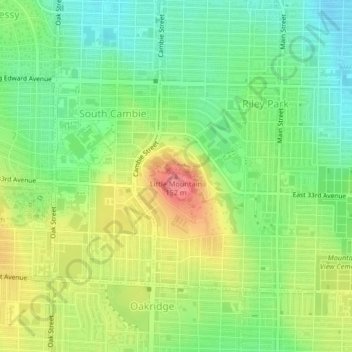
Nom : Carte topographique Little Mountain, altitude, relief.
Altitude moyenne : 81 m
Altitude minimum : 48 m
Altitude maximum : 127 m
Faire un don
Équipez-vous pour votre prochaine aventure :
En tant que Partenaire Amazon, ce site perçoit une commission sur les achats éligibles sans surcoût pour vous.
Autres cartes topographiques
Cliquez sur une carte pour visualiser sa topographie, son altitude et son relief.
Stanley Park
Canada > British Columbia > Metro Vancouver Regional District > Vancouver
Altitude moyenne : 14 m
Queen Elizabeth Park
Canada > British Columbia > Metro Vancouver Regional District > Vancouver
Altitude moyenne : 81 m
English Bay Beach
Canada > British Columbia > Metro Vancouver Regional District > Vancouver
Altitude moyenne : 12 m
Victoria-Fraserview
Canada > British Columbia > Metro Vancouver Regional District > Vancouver
Altitude moyenne : 67 m
Faire un don
Équipez-vous pour votre prochaine aventure :
En tant que Partenaire Amazon, ce site perçoit une commission sur les achats éligibles sans surcoût pour vous.
English Bay
Canada > British Columbia > Metro Vancouver Regional District > Vancouver
Altitude moyenne : 7 m
Livingstone Lake
Canada > British Columbia > Metro Vancouver Regional District > Vancouver
Altitude moyenne : 86 m
Jericho Beach
Canada > British Columbia > Metro Vancouver Regional District > Vancouver
Altitude moyenne : 20 m
Marpole
Canada > British Columbia > Metro Vancouver Regional District > Vancouver
Altitude moyenne : 28 m
Faire un don
Équipez-vous pour votre prochaine aventure :
En tant que Partenaire Amazon, ce site perçoit une commission sur les achats éligibles sans surcoût pour vous.
Trout Lake
Canada > British Columbia > Metro Vancouver Regional District > Vancouver
Altitude moyenne : 52 m
Vancouver East
Canada > British Columbia > Metro Vancouver Regional District > Vancouver
Altitude moyenne : 25 m
Renfrew-Collingwood
Canada > British Columbia > Metro Vancouver Regional District > Vancouver
Altitude moyenne : 72 m
Cypress Pond
Canada > British Columbia > Metro Vancouver Regional District > Vancouver
Altitude moyenne : 86 m
Faire un don
Équipez-vous pour votre prochaine aventure :
En tant que Partenaire Amazon, ce site perçoit une commission sur les achats éligibles sans surcoût pour vous.
Strathcona Park
Canada > British Columbia > Metro Vancouver Regional District > Vancouver
Altitude moyenne : 17 m
Still Creek
Canada > British Columbia > Metro Vancouver Regional District > Vancouver
Altitude moyenne : 65 m
Riley Park
Canada > British Columbia > Metro Vancouver Regional District > Vancouver
Altitude moyenne : 75 m
Arbutus-Ridge
Canada > British Columbia > Metro Vancouver Regional District > Vancouver
Altitude moyenne : 60 m
Faire un don
Équipez-vous pour votre prochaine aventure :
En tant que Partenaire Amazon, ce site perçoit une commission sur les achats éligibles sans surcoût pour vous.
Slocan Park
Canada > British Columbia > Metro Vancouver Regional District > Vancouver
Altitude moyenne : 81 m
Kitsilano 6
Canada > British Columbia > Metro Vancouver Regional District > Vancouver
Altitude moyenne : 22 m
Downtown
Canada > British Columbia > Metro Vancouver Regional District > Vancouver
Altitude moyenne : 14 m
Fraser River Park
Canada > British Columbia > Metro Vancouver Regional District > Vancouver
Altitude moyenne : 19 m
Faire un don
Équipez-vous pour votre prochaine aventure :
En tant que Partenaire Amazon, ce site perçoit une commission sur les achats éligibles sans surcoût pour vous.
Fairview
Canada > British Columbia > Metro Vancouver Regional District > Vancouver
Altitude moyenne : 31 m
West End
Canada > British Columbia > Metro Vancouver Regional District > Vancouver
Altitude moyenne : 15 m
Andy Livingstone Park
Canada > British Columbia > Metro Vancouver Regional District > Vancouver
Altitude moyenne : 12 m
False Creek
Canada > British Columbia > Metro Vancouver Regional District > Vancouver
Altitude moyenne : 18 m
Faire un don
Équipez-vous pour votre prochaine aventure :
En tant que Partenaire Amazon, ce site perçoit une commission sur les achats éligibles sans surcoût pour vous.
Killarney
Canada > British Columbia > Metro Vancouver Regional District > Vancouver
Altitude moyenne : 73 m
Kerrisdale
Canada > British Columbia > Metro Vancouver Regional District > Vancouver
Altitude moyenne : 39 m
Kitsilano
Canada > British Columbia > Metro Vancouver Regional District > Vancouver
Altitude moyenne : 24 m
Dunbar-Southlands
Canada > British Columbia > Metro Vancouver Regional District > Vancouver
Altitude moyenne : 43 m
Faire un don
Équipez-vous pour votre prochaine aventure :
En tant que Partenaire Amazon, ce site perçoit une commission sur les achats éligibles sans surcoût pour vous.
Kensington Park
Canada > British Columbia > Metro Vancouver Regional District > Vancouver
Altitude moyenne : 81 m
Granville Island
Canada > British Columbia > Metro Vancouver Regional District > Vancouver
Altitude moyenne : 25 m
Grandview-Woodland
Canada > British Columbia > Metro Vancouver Regional District > Vancouver
Altitude moyenne : 28 m
Kensington-Cedar Cottage
Canada > British Columbia > Metro Vancouver Regional District > Vancouver
Altitude moyenne : 64 m
Faire un don
Équipez-vous pour votre prochaine aventure :
En tant que Partenaire Amazon, ce site perçoit une commission sur les achats éligibles sans surcoût pour vous.
Sunset
Canada > British Columbia > Metro Vancouver Regional District > Vancouver
Altitude moyenne : 53 m
Mount Pleasant
Canada > British Columbia > Metro Vancouver Regional District > Vancouver
Altitude moyenne : 28 m
Cambie Park
Canada > British Columbia > Metro Vancouver Regional District > Vancouver
Altitude moyenne : 61 m
Charleson Park
Canada > British Columbia > Metro Vancouver Regional District > Vancouver
Altitude moyenne : 28 m
Faire un don
Équipez-vous pour votre prochaine aventure :
En tant que Partenaire Amazon, ce site perçoit une commission sur les achats éligibles sans surcoût pour vous.
Gaston Park
Canada > British Columbia > Metro Vancouver Regional District > Vancouver
Altitude moyenne : 104 m
Brewers Park
Canada > British Columbia > Metro Vancouver Regional District > Vancouver
Altitude moyenne : 64 m
Point Grey Park Site at Trutch Street
Canada > British Columbia > Metro Vancouver Regional District > Vancouver
Altitude moyenne : 15 m
Hastings-Sunrise
Canada > British Columbia > Metro Vancouver Regional District > Vancouver
Altitude moyenne : 40 m
Faire un don
Équipez-vous pour votre prochaine aventure :
En tant que Partenaire Amazon, ce site perçoit une commission sur les achats éligibles sans surcoût pour vous.
Strathcona
Canada > British Columbia > Metro Vancouver Regional District > Vancouver
Altitude moyenne : 10 m
McBride Park
Canada > British Columbia > Metro Vancouver Regional District > Vancouver
Altitude moyenne : 22 m
Kitsilano
Canada > British Columbia > Metro Vancouver Regional District > Vancouver
Altitude moyenne : 24 m
Queen Elizabeth Park
Canada > British Columbia > Metro Vancouver Regional District > Vancouver
Altitude moyenne : 81 m
Faire un don
Équipez-vous pour votre prochaine aventure :
En tant que Partenaire Amazon, ce site perçoit une commission sur les achats éligibles sans surcoût pour vous.
Queen Elizabeth Park
Canada > British Columbia > Metro Vancouver Regional District > Vancouver
Altitude moyenne : 81 m
Fairview
Canada > British Columbia > Metro Vancouver Regional District > Vancouver
Altitude moyenne : 31 m
Stanley Park
Canada > British Columbia > Metro Vancouver Regional District > Vancouver
Altitude moyenne : 14 m