
Faire un don
Équipez-vous pour votre prochaine aventure :
En tant que Partenaire Amazon, ce site perçoit une commission sur les achats éligibles sans surcoût pour vous.
Carte topographique Lockport
Cliquez sur la carte pour afficher l’altitude.
Faire un don
Équipez-vous pour votre prochaine aventure :
En tant que Partenaire Amazon, ce site perçoit une commission sur les achats éligibles sans surcoût pour vous.
Lockport
Lockport is at the junction of several major truck routes, including NY Route 78 (Transit Road), NY Route 31, NY Route 77 and NY Route 93. It is 17 miles north of Interstate 90 via NY Route 78. The highest point is the bell tower at 452 High Street, with the street itself being the highest street as measured by frontage above the 650 feet elevation.
Faire un don
Équipez-vous pour votre prochaine aventure :
En tant que Partenaire Amazon, ce site perçoit une commission sur les achats éligibles sans surcoût pour vous.
À propos de cette carte
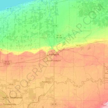
Nom : Carte topographique Lockport, altitude, relief.
Altitude moyenne : 152 m
Altitude minimum : 70 m
Altitude maximum : 260 m
Faire un don
Équipez-vous pour votre prochaine aventure :
En tant que Partenaire Amazon, ce site perçoit une commission sur les achats éligibles sans surcoût pour vous.
Autres cartes topographiques
Cliquez sur une carte pour visualiser sa topographie, son altitude et son relief.
City of Lockport
United States > New York > Niagara County
Lockport is at the junction of several major truck routes, including NY Route 78 (Transit Road), NY Route 31, NY Route 77 and NY Route 93. It is 17 miles north of Interstate 90 via NY Route 78. The highest point is the bell tower at 452 High Street, with the street itself being the highest street as measured…
Altitude moyenne : 174 m
Whirlpool State Park
United States > New York > Niagara County > City of Niagara Falls
Altitude moyenne : 165 m
Faire un don
Équipez-vous pour votre prochaine aventure :
En tant que Partenaire Amazon, ce site perçoit une commission sur les achats éligibles sans surcoût pour vous.
Ontario Pond
United States > New York > Niagara County > City of North Tonawanda
Altitude moyenne : 177 m
Niagara Escarpment
United States > New York > Niagara County > City of Lockport
Altitude moyenne : 149 m
Faire un don
Équipez-vous pour votre prochaine aventure :
En tant que Partenaire Amazon, ce site perçoit une commission sur les achats éligibles sans surcoût pour vous.
Niagara Falls
United States > New York > Niagara County > City of Niagara Falls
The peak flow over Horseshoe Falls was recorded at 6,370 cubic metres per second (225,000 cubic feet per second). The average annual flow rate is 2,400 m3/s (85,000 cu ft/s). Since the flow is a direct function of the Lake Erie water elevation, it typically peaks in late spring or early summer. During the…
Altitude moyenne : 170 m
Niagara Falls
United States > New York > Niagara County > City of Niagara Falls
The peak flow over Horseshoe Falls was recorded at 6,370 m3/s (225,000 cu ft/s). The average annual flow rate is 2,400 m3/s (85,000 cu ft/s). Since the flow is a direct function of the Lake Erie water elevation, it typically peaks in late spring or early summer. During the summer months, at least 2,800 m3/s…
Altitude moyenne : 170 m
City of Lockport
United States > New York > Niagara County
Lockport is at the junction of several major truck routes, including NY Route 78 (Transit Road), NY Route 31, NY Route 77 and NY Route 93. It is 17 miles north of Interstate 90 via NY Route 78. The highest point is the bell tower at 452 High Street, with the street itself being the highest street as measured…
Altitude moyenne : 174 m
Faire un don
Équipez-vous pour votre prochaine aventure :
En tant que Partenaire Amazon, ce site perçoit une commission sur les achats éligibles sans surcoût pour vous.
Niagara Escarpment
United States > New York > Niagara County > City of Lockport
Altitude moyenne : 149 m
Niagara Falls
United States > New York > Niagara County > City of Niagara Falls
The peak flow over Horseshoe Falls was recorded at 6,370 m3/s (225,000 cu ft/s). The average annual flow rate is 2,400 m3/s (85,000 cu ft/s). Since the flow is a direct function of the Lake Erie water elevation, it typically peaks in late spring or early summer. During the summer months, at least 2,800 m3/s…
Altitude moyenne : 170 m
Faire un don
Équipez-vous pour votre prochaine aventure :
En tant que Partenaire Amazon, ce site perçoit une commission sur les achats éligibles sans surcoût pour vous.
Niagara Escarpment
United States > New York > Niagara County > City of Lockport
Altitude moyenne : 149 m
Faire un don
Équipez-vous pour votre prochaine aventure :
En tant que Partenaire Amazon, ce site perçoit une commission sur les achats éligibles sans surcoût pour vous.