
Carte topographique Massachusetts
Carte interactive
Cliquez sur la carte pour afficher l’altitude.
À propos de cette carte
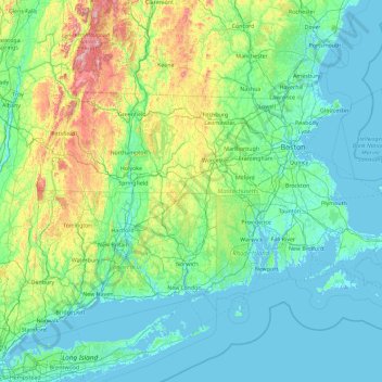
Nom : Carte topographique Massachusetts, altitude, relief.
Lieu : Massachusetts, United States (41.18886 -73.50821 42.88678 -69.86010)
Altitude moyenne : 128 m
Altitude minimum : -7 m
Altitude maximum : 1 159 m
Despite its small size, Massachusetts features numerous topographically distinctive regions. The large coastal plain of the Atlantic Ocean in the eastern section of the state contains Greater Boston, along with most of the state's population, as well as the distinctive Cape Cod peninsula. To the west lies the hilly, rural region of Central Massachusetts, and beyond that, the Connecticut River Valley. Along the western border of Western Massachusetts lies the highest elevated part of the state, the Berkshires, forming a portion of the northern terminus of the Appalachian Mountains.
Autres cartes topographiques
Cliquez sur une carte pour visualiser sa topographie, son altitude et son relief.
Brooklyn
United States > New York > New York
Brooklyn, Kings County, New York, United States
Altitude moyenne : 9 m
Houston
United States > Texas > Harris County
Houston, Harris County, Texas, United States
Altitude moyenne : 25 m
Santa Cruz
United States > California > Santa Cruz County
Santa Cruz, Santa Cruz County, California, United States
Altitude moyenne : 89 m
Albuquerque
United States > New Mexico > Bernalillo County
Albuquerque, Bernalillo County, New Mexico, United States
Altitude moyenne : 1 688 m
Boulder
United States > Colorado > Boulder County
Boulder, Boulder County, Colorado, United States
Altitude moyenne : 1 785 m
Appalachian Mountains
United States > North Carolina > Yancey County
Appalachian Mountains, Yancey County, North Carolina, United States
Altitude moyenne : 1 463 m
Des Moines
United States > Iowa > Polk County
Des Moines, Polk County, Iowa, United States
Altitude moyenne : 264 m
New Orleans
United States > Louisiana > Orleans Parish
New Orleans, Orleans Parish, Louisiana, United States
Altitude moyenne : 1 m
Mount Hood
United States > Oregon > Hood River County
Mount Hood, Hood River County, Oregon, United States
Altitude moyenne : 2 716 m
Arlington
United States > Massachusetts > Middlesex County
Arlington, Middlesex County, Massachusetts, United States
Altitude moyenne : 35 m
Worcester
United States > Massachusetts > Worcester County
Worcester, Worcester County, Massachusetts, United States
Altitude moyenne : 186 m
Amelia Island
United States > Florida > Nassau County > Fernandina Beach
Amelia Island, Fernandina Beach, Nassau County, Florida, 32034, United States
Altitude moyenne : 3 m
Fairfax County
Fairfax County, Virginia, United States
Altitude moyenne : 75 m
Lancaster County
Lancaster County, Pennsylvania, United States
Altitude moyenne : 158 m
Manhattan
United States > New York > New York County > New York
Manhattan, New York County, New York, United States
Altitude moyenne : 16 m
Brunswick County
United States > North Carolina
Brunswick County, North Carolina, United States
Altitude moyenne : 9 m
Bronx County
United States > New York > New York
Bronx County, The Bronx, New York, United States
Altitude moyenne : 21 m
Lexington
United States > Kentucky > Lexington
Lexington, Fayette County, Kentucky, 40508, United States
Altitude moyenne : 285 m
Whatcom County
Whatcom County, Washington, United States
Altitude moyenne : 753 m