
Carte topographique Idaho
Carte interactive
Cliquez sur la carte pour afficher l’altitude.
À propos de cette carte
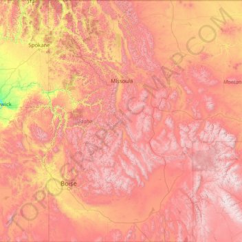
Nom : Carte topographique Idaho, altitude, relief.
Lieu : Idaho, United States (41.98883 -117.24303 49.00084 -111.04356)
Altitude moyenne : 1 533 m
Altitude minimum : 102 m
Altitude maximum : 4 034 m
Idaho's climate varies widely. Although the state's western border is about 330 miles (530 km) from the Pacific Ocean, the maritime influence is still felt in Idaho; especially, in the winter when cloud cover, humidity, and precipitation are at their maximum extent. This influence has a moderating effect in the winter where temperatures are not as low as would otherwise be expected for a northern state with predominantly high elevations. In the panhandle, moist air masses from the coast are released as precipitation over the North Central Rockies forests, creating the North American inland temperate rainforest. The maritime influence is least prominent in the state's eastern part where the precipitation patterns are often reversed, with wetter summers and drier winters, and seasonal temperature differences are more extreme, showing a more semi-arid continental climate.
Autres cartes topographiques
Cliquez sur une carte pour visualiser sa topographie, son altitude et son relief.
Brooklyn
United States > New York > New York
Brooklyn, Kings County, New York, United States
Altitude moyenne : 9 m
Houston
United States > Texas > Harris County
Houston, Harris County, Texas, United States
Altitude moyenne : 25 m
Hillsborough County
Hillsborough County, Florida, United States
Altitude moyenne : 20 m
Jacksonville
United States > Florida > Duval County
Jacksonville, Duval County, Florida, United States
Altitude moyenne : 10 m
Santa Cruz
United States > California > Santa Cruz County
Santa Cruz, Santa Cruz County, California, United States
Altitude moyenne : 89 m
Arlington
United States > Massachusetts > Middlesex County
Arlington, Middlesex County, Massachusetts, United States
Altitude moyenne : 35 m
Whatcom County
Whatcom County, Washington, United States
Altitude moyenne : 753 m
Hudson River
Hudson River, New Jersey, 12834:12871, United States
Altitude moyenne : 297 m
Parker
United States > Colorado > Douglas County
Parker, Douglas County, Colorado, 80134, United States
Altitude moyenne : 1 845 m
Cape Cod
United States > Massachusetts > Plymouth County
Cape Cod, Plymouth County, Massachusetts, United States
Altitude moyenne : 2 m
Appalachian Mountains
United States > North Carolina > Yancey County
Appalachian Mountains, Yancey County, North Carolina, United States
Altitude moyenne : 1 463 m
Manhattan
United States > New York > New York County > New York
Manhattan, New York County, New York, United States
Altitude moyenne : 16 m
Albuquerque
United States > New Mexico > Bernalillo County
Albuquerque, Bernalillo County, New Mexico, United States
Altitude moyenne : 1 688 m
Provo
United States > Utah > Utah County
Provo, Utah County, Utah, United States
Altitude moyenne : 1 728 m
Aurora
United States > Colorado > Adams County
Aurora, Adams County, Colorado, United States
Altitude moyenne : 1 691 m
Spokane
United States > Washington > Spokane County
Spokane, Spokane County, Washington, United States
Altitude moyenne : 655 m
San Mateo County
San Mateo County, California, United States
Altitude moyenne : 109 m