
Carte topographique Montana
Carte interactive
Cliquez sur la carte pour afficher l’altitude.
À propos de cette carte
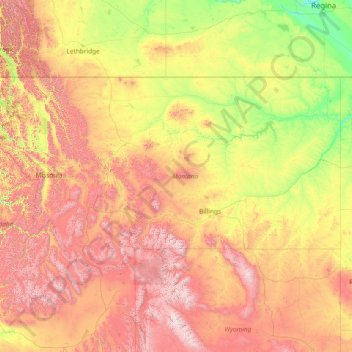
Nom : Carte topographique Montana, altitude, relief.
Lieu : Montana, United States (44.35792 -116.04923 49.00111 -104.03956)
Altitude moyenne : 1 357 m
Altitude minimum : 552 m
Altitude maximum : 4 034 m
The state's topography is roughly defined by the Continental Divide, which splits much of the state into distinct eastern and western regions. Most of Montana's hundred or more named mountain ranges are in the state's western half, most of which is geologically and geographically part of the northern Rocky Mountains. The Absaroka and Beartooth ranges in the state's south-central part are technically part of the Central Rocky Mountains. The Rocky Mountain Front is a significant feature in the state's north-central portion, and isolated island ranges that interrupt the prairie landscape common in the central and eastern parts of the state. About 60 percent of the state is prairie, part of the northern Great Plains.
Autres cartes topographiques
Cliquez sur une carte pour visualiser sa topographie, son altitude et son relief.
Spokane
United States > Washington > Spokane County
Spokane, Spokane County, Washington, United States
Altitude moyenne : 655 m
Houston
United States > Texas > Harris County
Houston, Harris County, Texas, United States
Altitude moyenne : 25 m
Brooklyn
United States > New York > New York
Brooklyn, Kings County, New York, United States
Altitude moyenne : 9 m
New Orleans
United States > Louisiana > Orleans Parish
New Orleans, Orleans Parish, Louisiana, United States
Altitude moyenne : 1 m
Albuquerque
United States > New Mexico > Bernalillo County
Albuquerque, Bernalillo County, New Mexico, United States
Altitude moyenne : 1 688 m
Boulder
United States > Colorado > Boulder County
Boulder, Boulder County, Colorado, United States
Altitude moyenne : 1 785 m
College Station
United States > Texas > Brazos County
College Station, Brazos County, Texas, United States
Altitude moyenne : 87 m
Montgomery County
Montgomery County, Texas, United States
Altitude moyenne : 69 m
Jacksonville
United States > Florida > Duval County
Jacksonville, Duval County, Florida, United States
Altitude moyenne : 10 m
Fort Worth
United States > Texas > Tarrant County
Fort Worth, Tarrant County, Texas, United States
Altitude moyenne : 212 m
Kauai
United States > Hawaii > Kauaʻi County
Kauai, Kauaʻi County, Hawaii, United States
Altitude moyenne : 216 m
Oakland County
Oakland County, Michigan, United States
Altitude moyenne : 282 m
Lexington
United States > Kentucky > Lexington
Lexington, Fayette County, Kentucky, 40508, United States
Altitude moyenne : 285 m
Whatcom County
Whatcom County, Washington, United States
Altitude moyenne : 753 m
Kitsap County
Kitsap County, Washington, United States
Altitude moyenne : 138 m
Indianapolis
United States > Indiana > Indianapolis
Indianapolis, Marion County, Indiana, 46204, United States
Altitude moyenne : 241 m