
Carte topographique Springston
Carte interactive
Cliquez sur la carte pour afficher l’altitude.
À propos de cette carte
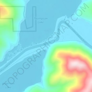
Nom : Carte topographique Springston, altitude, relief.
Altitude moyenne : 721 m
Altitude minimum : 644 m
Altitude maximum : 1 056 m
Autres cartes topographiques
Cliquez sur une carte pour visualiser sa topographie, son altitude et son relief.
Snake River
United States of America > Idaho
Snake River, Washington County, Idaho, 83672, United States of America
Altitude moyenne : 644 m
Sawtooth National Forest
United States of America > Idaho > Rupert
Sawtooth National Forest, Sharon Court, Rupert, Minidoka County, Idaho, 83350, United States of America
Altitude moyenne : 1 608 m
Genesee
United States of America > Idaho > Genesee
Genesee, Latah County, Idaho, 83832, United States of America
Altitude moyenne : 824 m
Butte County
United States of America > Idaho
Butte County, Idaho, United States of America
Altitude moyenne : 1 914 m
Chinese Peak
United States of America > Idaho
Chinese Peak, Bannock County, Idaho, United States of America
Altitude moyenne : 1 830 m
Camas County
United States of America > Idaho
Camas County, Idaho, United States of America
Altitude moyenne : 2 002 m
Eagle Rock
United States of America > Idaho
Eagle Rock, Idaho County, Idaho, United States of America
Altitude moyenne : 1 164 m
Teton
United States of America > Idaho > Teton
Teton, Fremont County, Idaho, 83451, United States of America
Altitude moyenne : 1 509 m