
Carte topographique Camas County
Carte interactive
Cliquez sur la carte pour afficher l’altitude.
À propos de cette carte
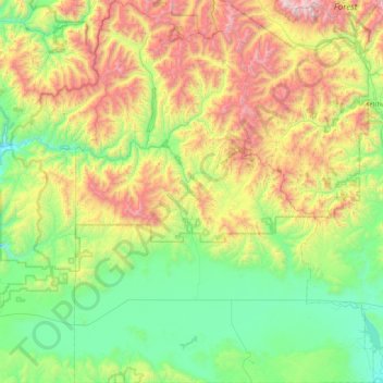
Nom : Carte topographique Camas County, altitude, relief.
Lieu : Camas County, Idaho, United States of America (43.19842 -115.08668 43.85861 -114.37772)
Altitude moyenne : 2 002 m
Altitude minimum : 1 375 m
Altitude maximum : 3 406 m
U.S. Highway 20 runs east–west through the county's center, at elevations just over 5,000 feet (1,520 m) above sea level, connecting west to Mountain Home in Elmore County; to the east it intersects State Highway 75 in Blaine County. The northern terminus of State Highway 46 is at US-20, four miles (6.4 km) east of Fairfield; it runs south over the Mount Bennett Hills into Gooding County and on to Gooding.
Autres cartes topographiques
Cliquez sur une carte pour visualiser sa topographie, son altitude et son relief.
Snake River
United States of America > Idaho
Snake River, Washington County, Idaho, 83672, United States of America
Altitude moyenne : 644 m
Sawtooth National Forest
United States of America > Idaho > Rupert
Sawtooth National Forest, Sharon Court, Rupert, Minidoka County, Idaho, 83350, United States of America
Altitude moyenne : 1 608 m
Genesee
United States of America > Idaho > Genesee
Genesee, Latah County, Idaho, 83832, United States of America
Altitude moyenne : 824 m
Butte County
United States of America > Idaho
Butte County, Idaho, United States of America
Altitude moyenne : 1 914 m
Chinese Peak
United States of America > Idaho
Chinese Peak, Bannock County, Idaho, United States of America
Altitude moyenne : 1 830 m
Eagle Rock
United States of America > Idaho
Eagle Rock, Idaho County, Idaho, United States of America
Altitude moyenne : 1 164 m
Teton
United States of America > Idaho > Teton
Teton, Fremont County, Idaho, 83451, United States of America
Altitude moyenne : 1 509 m
Springston
United States of America > Idaho
Springston, Kootenai County, Idaho, 83833, United States of America
Altitude moyenne : 721 m