
Faire un don
Équipez-vous pour votre prochaine aventure :
En tant que Partenaire Amazon, ce site perçoit une commission sur les achats éligibles sans surcoût pour vous.
Carte topographique Bute Inlet
Cliquez sur la carte pour afficher l’altitude.
Faire un don
Équipez-vous pour votre prochaine aventure :
En tant que Partenaire Amazon, ce site perçoit une commission sur les achats éligibles sans surcoût pour vous.
Bute Inlet
The Bute Inlet route was later considered for the mainline of the Canadian Pacific Railway (CPR), which would have seen extensive blasting down the west shore of the inlet and a series of bridges to reach Vancouver Island near Campbell River via Seymour Narrows. This route was passed over in favour of the Fraser Canyon route to a new port-city at Burrard Inlet, which was to become the city of Port Moody. The residual political impact of the Chilcotin War was one factor dissuading the CPR from using Bute Inlet; the other was the severe grades required in the canyon of the Homathko River in order to reach the elevation of the Chilcotin Plateau on the inland side of the Coast Range, as well as the cost of blasting along the inlet and the deep water bridges needed below it.
Faire un don
Équipez-vous pour votre prochaine aventure :
En tant que Partenaire Amazon, ce site perçoit une commission sur les achats éligibles sans surcoût pour vous.
À propos de cette carte
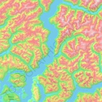
Nom : Carte topographique Bute Inlet, altitude, relief.
Altitude moyenne : 921 m
Altitude minimum : 0 m
Altitude maximum : 2 636 m
Faire un don
Équipez-vous pour votre prochaine aventure :
En tant que Partenaire Amazon, ce site perçoit une commission sur les achats éligibles sans surcoût pour vous.
Autres cartes topographiques
Cliquez sur une carte pour visualiser sa topographie, son altitude et son relief.
Quathiaski Cove
Canada > British Columbia > Strathcona Regional District > Area B (Discovery Islands/Mainland Inlets)
Altitude moyenne : 40 m
Broken Islands
Canada > British Columbia > Strathcona Regional District > Area B (Discovery Islands/Mainland Inlets)
Altitude moyenne : 10 m
Mount Bute
Canada > British Columbia > Strathcona Regional District > Area B (Discovery Islands/Mainland Inlets)
Altitude moyenne : 1 993 m
Mount Hayes
Canada > British Columbia > Strathcona Regional District > Area B (Discovery Islands/Mainland Inlets)
Altitude moyenne : 1 101 m
Faire un don
Équipez-vous pour votre prochaine aventure :
En tant que Partenaire Amazon, ce site perçoit une commission sur les achats éligibles sans surcoût pour vous.
Heriot Bay
Canada > British Columbia > Strathcona Regional District > Area B (Discovery Islands/Mainland Inlets)
Altitude moyenne : 38 m
Mount Raleigh
Canada > British Columbia > Strathcona Regional District > Area B (Discovery Islands/Mainland Inlets)
Mount Raleigh, elevation 3,132 m (10,276 ft), is one of the principal summits of the Pacific Ranges of the Coast Mountains of southern British Columbia in Canada. It is located just southeast of the confluence of the Southgate and Bishop Rivers, northeast of the head of Bute Inlet, and is the highest summit…
Altitude moyenne : 2 414 m
Discovery Mountain
Canada > British Columbia > Strathcona Regional District > Area B (Discovery Islands/Mainland Inlets)
Altitude moyenne : 361 m
Ripple Rock
Canada > British Columbia > Strathcona Regional District > Area B (Discovery Islands/Mainland Inlets)
Altitude moyenne : 40 m
Faire un don
Équipez-vous pour votre prochaine aventure :
En tant que Partenaire Amazon, ce site perçoit une commission sur les achats éligibles sans surcoût pour vous.
Pembroke Range
Canada > British Columbia > Strathcona Regional District > Area B (Discovery Islands/Mainland Inlets)
Altitude moyenne : 633 m