
Faire un don
Équipez-vous pour votre prochaine aventure :
En tant que Partenaire Amazon, ce site perçoit une commission sur les achats éligibles sans surcoût pour vous.
Carte topographique Ripple Rock
Cliquez sur la carte pour afficher l’altitude.
Faire un don
Équipez-vous pour votre prochaine aventure :
En tant que Partenaire Amazon, ce site perçoit une commission sur les achats éligibles sans surcoût pour vous.
À propos de cette carte
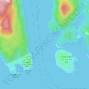
Nom : Carte topographique Ripple Rock, altitude, relief.
Altitude moyenne : 40 m
Altitude minimum : -1 m
Altitude maximum : 263 m
Faire un don
Équipez-vous pour votre prochaine aventure :
En tant que Partenaire Amazon, ce site perçoit une commission sur les achats éligibles sans surcoût pour vous.
Autres cartes topographiques
Cliquez sur une carte pour visualiser sa topographie, son altitude et son relief.
Quadra Island
Canada > British Columbia > Strathcona Regional District > Area B (Discovery Islands/Mainland Inlets)
Altitude moyenne : 128 m
Bute Inlet
Canada > British Columbia > Strathcona Regional District > Area B (Discovery Islands/Mainland Inlets)
The Bute Inlet route was later considered for the mainline of the Canadian Pacific Railway (CPR), which would have seen extensive blasting down the west shore of the inlet and a series of bridges to reach Vancouver Island near Campbell River via Seymour Narrows. This route was passed over in favour of the…
Altitude moyenne : 921 m
Whiterock Passage
Canada > British Columbia > Strathcona Regional District > Area B (Discovery Islands/Mainland Inlets)
Altitude moyenne : 174 m
East Redonda Island
Canada > British Columbia > Strathcona Regional District > Area B (Discovery Islands/Mainland Inlets)
Altitude moyenne : 327 m
Faire un don
Équipez-vous pour votre prochaine aventure :
En tant que Partenaire Amazon, ce site perçoit une commission sur les achats éligibles sans surcoût pour vous.
Sonora Island
Canada > British Columbia > Strathcona Regional District > Area B (Discovery Islands/Mainland Inlets)
Altitude moyenne : 186 m
Broken Islands
Canada > British Columbia > Strathcona Regional District > Area B (Discovery Islands/Mainland Inlets)
Altitude moyenne : 10 m
Hardwicke Island
Canada > British Columbia > Strathcona Regional District > Area B (Discovery Islands/Mainland Inlets)
Altitude moyenne : 132 m
Heriot Bay
Canada > British Columbia > Strathcona Regional District > Area B (Discovery Islands/Mainland Inlets) > Heriot Bay
Altitude moyenne : 44 m
Faire un don
Équipez-vous pour votre prochaine aventure :
En tant que Partenaire Amazon, ce site perçoit une commission sur les achats éligibles sans surcoût pour vous.
Yorke Island
Canada > British Columbia > Strathcona Regional District > Area B (Discovery Islands/Mainland Inlets)
Altitude moyenne : 9 m
Jackson Bay
Canada > British Columbia > Strathcona Regional District > Area B (Discovery Islands/Mainland Inlets)
Altitude moyenne : 118 m
Quadra Island
Canada > British Columbia > Strathcona Regional District > Area B (Discovery Islands/Mainland Inlets)
Altitude moyenne : 128 m