
Carte topographique Lake County
Carte interactive
Cliquez sur la carte pour afficher l’altitude.
À propos de cette carte
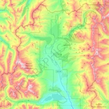
Nom : Carte topographique Lake County, altitude, relief.
Lieu : Lake County, Colorado, United States (39.05652 -106.58674 39.38371 -106.13586)
Altitude moyenne : 3 398 m
Altitude minimum : 2 739 m
Altitude maximum : 4 388 m
Lake County is one of 64 counties in the U.S. state of Colorado. As of the 2010 census, the population was 7,310. The county seat and the only municipality in the county is Leadville. The highest natural point in Colorado and the entire Rocky Mountains is the summit of Mount Elbert in Lake County at 14,440 feet (4401.2 meters) elevation.
Autres cartes topographiques
Cliquez sur une carte pour visualiser sa topographie, son altitude et son relief.
Mount Sherman
United States > Colorado > Lake County
Mount Sherman, Lake County, Colorado, United States
Altitude moyenne : 3 989 m
Leadville
United States > Colorado > Lake County
Leadville, Lake County, Colorado, 80461, United States
Altitude moyenne : 3 106 m
Leadville
United States > Colorado > Lake County
Leadville, Lake County, Colorado, 80461, United States
Altitude moyenne : 3 106 m
Mount Elbert
United States > Colorado > Lake County
Mount Elbert, Lake County, Colorado, United States
Altitude moyenne : 3 958 m