
Carte topographique Mount Elbert
Carte interactive
Cliquez sur la carte pour afficher l’altitude.
À propos de cette carte
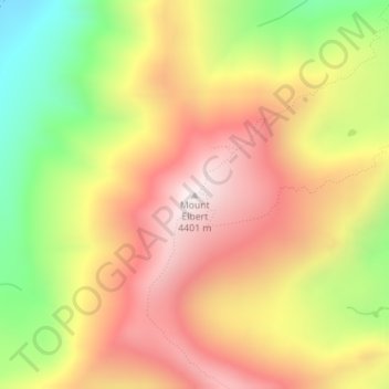
Nom : Carte topographique Mount Elbert, altitude, relief.
Lieu : Mount Elbert, Lake County, Colorado, United States (39.11793 -106.44510 39.11803 -106.44500)
Altitude moyenne : 3 958 m
Altitude minimum : 3 421 m
Altitude maximum : 4 394 m
The summit of Mount Elbert at 14,440 feet (4401.2 m) elevation is the highest summit of the Rocky Mountains of North America, the highest point in the U.S. State of Colorado, and the second-highest summit in the contiguous United States after Mount Whitney. The ultra-prominent fourteener is the highest peak in the Sawatch Range, as well as the highest point in the entire Mississippi River drainage basin. Mount Elbert is located in San Isabel National Forest, 12.1 miles (19.4 km) southwest (bearing 223°) of the City of Leadville in Lake County, Colorado.
Autres cartes topographiques
Cliquez sur une carte pour visualiser sa topographie, son altitude et son relief.
Mount Sherman
United States > Colorado > Lake County
Mount Sherman, Lake County, Colorado, United States
Altitude moyenne : 3 989 m
Leadville
United States > Colorado > Lake County
Leadville, Lake County, Colorado, 80461, United States
Altitude moyenne : 3 106 m
Leadville
United States > Colorado > Lake County
Leadville, Lake County, Colorado, 80461, United States
Altitude moyenne : 3 106 m
Lake County
United States > Colorado > Lake County
Lake County, Colorado, United States
Altitude moyenne : 3 398 m