
Faire un don
Équipez-vous pour votre prochaine aventure :
En tant que Partenaire Amazon, ce site perçoit une commission sur les achats éligibles sans surcoût pour vous.
Carte topographique Pemberton
Cliquez sur la carte pour afficher l’altitude.
Faire un don
Équipez-vous pour votre prochaine aventure :
En tant que Partenaire Amazon, ce site perçoit une commission sur les achats éligibles sans surcoût pour vous.
Pemberton
The climate of Pemberton is very warm and dry in the summer and mild and wet in the winter. Pemberton is an ecologically complex and diverse zone which is referred to as the Coast-Interior Transition zone. Moving from west to east in the direction of the prevailing winds and taking into consideration the elevation changes; it follows that there is a windward, wetter zone and a leeward drier zone and an even drier zone on the leeward side of the Lillooet Ranges and the Pacific Ranges north of the rail line. High summer temperatures and the pronounced water deficits during the growing season are the norm.
Faire un don
Équipez-vous pour votre prochaine aventure :
En tant que Partenaire Amazon, ce site perçoit une commission sur les achats éligibles sans surcoût pour vous.
À propos de cette carte
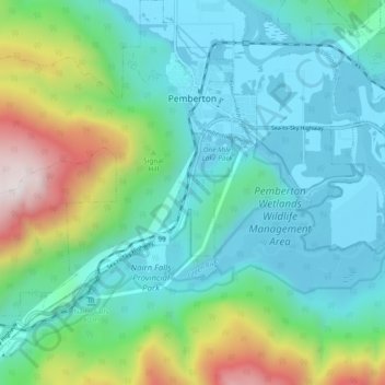
Nom : Carte topographique Pemberton, altitude, relief.
Altitude moyenne : 1 006 m
Altitude minimum : 199 m
Altitude maximum : 2 577 m
Faire un don
Équipez-vous pour votre prochaine aventure :
En tant que Partenaire Amazon, ce site perçoit une commission sur les achats éligibles sans surcoût pour vous.
Autres cartes topographiques
Cliquez sur une carte pour visualiser sa topographie, son altitude et son relief.
Mount Currie
Canada > British Columbia > Squamish-Lillooet Regional District > Area C (Pemberton Valley/Mount Currie/D'Arcy)
Altitude moyenne : 2 107 m
Whistler
Canada > British Columbia > Squamish-Lillooet Regional District > Whistler Resort Municipality > Whistler
Altitude moyenne : 996 m
Alice Lake
Canada > British Columbia > Squamish-Lillooet Regional District > Squamish
Altitude moyenne : 247 m
The Galapagos Islands Boulder
Canada > British Columbia > Squamish-Lillooet Regional District > Squamish
Altitude moyenne : 289 m
Faire un don
Équipez-vous pour votre prochaine aventure :
En tant que Partenaire Amazon, ce site perçoit une commission sur les achats éligibles sans surcoût pour vous.
Wedgemount Falls
Canada > British Columbia > Squamish-Lillooet Regional District > Area C (Pemberton Valley/Mount Currie/D'Arcy)
Altitude moyenne : 1 913 m
Sunshine Mountain
Canada > British Columbia > Squamish-Lillooet Regional District > Area A (Upper Bridge River Valley)
Altitude moyenne : 1 965 m
Mount Rohr
Canada > British Columbia > Squamish-Lillooet Regional District > Area B (Cayoosh/Pavilion)
Altitude moyenne : 1 940 m
Furry Creek
Canada > British Columbia > Squamish-Lillooet Regional District > Area D (Elaho/Garibaldi)
Altitude moyenne : 224 m
Faire un don
Équipez-vous pour votre prochaine aventure :
En tant que Partenaire Amazon, ce site perçoit une commission sur les achats éligibles sans surcoût pour vous.
Mount Rohr
Canada > British Columbia > Squamish-Lillooet Regional District > Area B (Cayoosh/Pavilion)
Altitude moyenne : 1 940 m
Whistler Olympic Park
Canada > British Columbia > Squamish-Lillooet Regional District > Area D (Elaho/Garibaldi)
Altitude moyenne : 954 m
Beacon Mountain
Canada > British Columbia > Squamish-Lillooet Regional District > Area C (Pemberton Valley/Mount Currie/D'Arcy)
Altitude moyenne : 1 496 m
Lost Peak
Canada > British Columbia > Squamish-Lillooet Regional District > Area B (Cayoosh/Pavilion)
Altitude moyenne : 2 176 m
Faire un don
Équipez-vous pour votre prochaine aventure :
En tant que Partenaire Amazon, ce site perçoit une commission sur les achats éligibles sans surcoût pour vous.
Mount Meager
Canada > British Columbia > Squamish-Lillooet Regional District > Area C (Pemberton Valley/Mount Currie/D'Arcy)
Altitude moyenne : 2 110 m
Mount Meager
Canada > British Columbia > Squamish-Lillooet Regional District > Area C (Pemberton Valley/Mount Currie/D'Arcy)
Altitude moyenne : 2 110 m
Whistler Mountain
Canada > British Columbia > Squamish-Lillooet Regional District > Whistler
There is a weather station near the summit of Whistler Mountain at the Roundhouse Lodge, located at an elevation of 1835 m (6020 ft). Whistler Roundhouse has a dry-summer subalpine climate (Köppen Dsc), bordering on an Alpine climate (Köppen ET).
Altitude moyenne : 1 810 m
Faire un don
Équipez-vous pour votre prochaine aventure :
En tant que Partenaire Amazon, ce site perçoit une commission sur les achats éligibles sans surcoût pour vous.
Gold Bridge
Canada > British Columbia > Squamish-Lillooet Regional District > Area A (Upper Bridge River Valley)
Altitude moyenne : 886 m
The Galapagos Islands Boulder
Canada > British Columbia > Squamish-Lillooet Regional District > Squamish
Altitude moyenne : 289 m
Mount Meager
Canada > British Columbia > Squamish-Lillooet Regional District > Area C (Pemberton Valley/Mount Currie/D'Arcy)
Altitude moyenne : 2 110 m
Edith Lake
Canada > British Columbia > Squamish-Lillooet Regional District > Squamish
Altitude moyenne : 309 m
Faire un don
Équipez-vous pour votre prochaine aventure :
En tant que Partenaire Amazon, ce site perçoit une commission sur les achats éligibles sans surcoût pour vous.
Slhanay
Canada > British Columbia > Squamish-Lillooet Regional District > Area D (Elaho/Garibaldi)
Altitude moyenne : 363 m
Watts Point
Canada > British Columbia > Squamish-Lillooet Regional District > Squamish
Altitude moyenne : 44 m
Locomotive Mountain
Canada > British Columbia > Squamish-Lillooet Regional District > Area C (Pemberton Valley/Mount Currie/D'Arcy)
Altitude moyenne : 1 951 m
Gin Peak
Canada > British Columbia > Squamish-Lillooet Regional District > Area C (Pemberton Valley/Mount Currie/D'Arcy)
Altitude moyenne : 1 518 m
Faire un don
Équipez-vous pour votre prochaine aventure :
En tant que Partenaire Amazon, ce site perçoit une commission sur les achats éligibles sans surcoût pour vous.
Marble Canyon
Canada > British Columbia > Squamish-Lillooet Regional District > Area B (Cayoosh/Pavilion)
Altitude moyenne : 1 141 m
D'Arcy
Canada > British Columbia > Squamish-Lillooet Regional District > Area C (Pemberton Valley/Mount Currie/D'Arcy)
Altitude moyenne : 461 m
Mount Sloan
Canada > British Columbia > Squamish-Lillooet Regional District > Area A (Upper Bridge River Valley)
Altitude moyenne : 2 089 m
Mount Fergusson
Canada > British Columbia > Squamish-Lillooet Regional District > Area A (Upper Bridge River Valley)
Altitude moyenne : 2 156 m
Faire un don
Équipez-vous pour votre prochaine aventure :
En tant que Partenaire Amazon, ce site perçoit une commission sur les achats éligibles sans surcoût pour vous.
Soprano Peak
Canada > British Columbia > Squamish-Lillooet Regional District > Area B (Cayoosh/Pavilion)
Altitude moyenne : 2 137 m
The Table
Canada > British Columbia > Squamish-Lillooet Regional District > Area D (Elaho/Garibaldi)
Altitude moyenne : 1 623 m
The Black Tusk (True Summit)
Canada > British Columbia > Squamish-Lillooet Regional District > Area D (Elaho/Garibaldi)
Altitude moyenne : 1 875 m
The Copilot
Canada > British Columbia > Squamish-Lillooet Regional District > Area D (Elaho/Garibaldi)
Altitude moyenne : 1 466 m
Faire un don
Équipez-vous pour votre prochaine aventure :
En tant que Partenaire Amazon, ce site perçoit une commission sur les achats éligibles sans surcoût pour vous.
Mt. Mulligan
Canada > British Columbia > Squamish-Lillooet Regional District > Area D (Elaho/Garibaldi)
Altitude moyenne : 1 159 m
Ring Mountain
Canada > British Columbia > Squamish-Lillooet Regional District > Area D (Elaho/Garibaldi)
Altitude moyenne : 1 816 m
Brandywine
Canada > British Columbia > Squamish-Lillooet Regional District > Area D (Elaho/Garibaldi)
Altitude moyenne : 515 m
Spruce Lake
Canada > British Columbia > Squamish-Lillooet Regional District > Area A (Upper Bridge River Valley)
Altitude moyenne : 1 688 m
Faire un don
Équipez-vous pour votre prochaine aventure :
En tant que Partenaire Amazon, ce site perçoit une commission sur les achats éligibles sans surcoût pour vous.
Bralorne
Canada > British Columbia > Squamish-Lillooet Regional District > Area A (Upper Bridge River Valley)
Altitude moyenne : 1 255 m
The Black Tusk
Canada > British Columbia > Squamish-Lillooet Regional District > Area D (Elaho/Garibaldi)
Altitude moyenne : 1 874 m
Seton Portage
Canada > British Columbia > Squamish-Lillooet Regional District > Area B (Cayoosh/Pavilion)
Altitude moyenne : 523 m
Metal Dome
Canada > British Columbia > Squamish-Lillooet Regional District > Area D (Elaho/Garibaldi)
Altitude moyenne : 1 678 m
Faire un don
Équipez-vous pour votre prochaine aventure :
En tant que Partenaire Amazon, ce site perçoit une commission sur les achats éligibles sans surcoût pour vous.
Elfin Lakes
Canada > British Columbia > Squamish-Lillooet Regional District > Area D (Elaho/Garibaldi)
Altitude moyenne : 1 331 m
Cheekye River
Canada > British Columbia > Squamish-Lillooet Regional District > Area D (Elaho/Garibaldi)
Altitude moyenne : 634 m
Furry Creek
Canada > British Columbia > Squamish-Lillooet Regional District > Area D (Elaho/Garibaldi)
Altitude moyenne : 224 m
Cirque Peak
Canada > British Columbia > Squamish-Lillooet Regional District > Area C (Pemberton Valley/Mount Currie/D'Arcy)
Altitude moyenne : 1 999 m
Faire un don
Équipez-vous pour votre prochaine aventure :
En tant que Partenaire Amazon, ce site perçoit une commission sur les achats éligibles sans surcoût pour vous.
Gun Creek
Canada > British Columbia > Squamish-Lillooet Regional District > Area A (Upper Bridge River Valley)
Altitude moyenne : 1 373 m
Onion Peak
Canada > British Columbia > Squamish-Lillooet Regional District > Area B (Cayoosh/Pavilion)
Altitude moyenne : 2 263 m
Little Big Horn
Canada > British Columbia > Squamish-Lillooet Regional District > Area A (Upper Bridge River Valley)
Altitude moyenne : 1 986 m
Lake La Mare Recreation Site
Canada > British Columbia > Squamish-Lillooet Regional District > Area B (Cayoosh/Pavilion)
Altitude moyenne : 1 272 m
Faire un don
Équipez-vous pour votre prochaine aventure :
En tant que Partenaire Amazon, ce site perçoit une commission sur les achats éligibles sans surcoût pour vous.
Beach Mountain
Canada > British Columbia > Squamish-Lillooet Regional District > Area C (Pemberton Valley/Mount Currie/D'Arcy)
Altitude moyenne : 2 063 m
Nairn Falls
Canada > British Columbia > Squamish-Lillooet Regional District > Area C (Pemberton Valley/Mount Currie/D'Arcy)
Altitude moyenne : 545 m
Exodus Peak
Canada > British Columbia > Squamish-Lillooet Regional District > Area C (Pemberton Valley/Mount Currie/D'Arcy)
Altitude moyenne : 2 115 m
Whistler Village
Canada > British Columbia > Squamish-Lillooet Regional District > Whistler
Altitude moyenne : 775 m
Faire un don
Équipez-vous pour votre prochaine aventure :
En tant que Partenaire Amazon, ce site perçoit une commission sur les achats éligibles sans surcoût pour vous.
Mount Brew
Canada > British Columbia > Squamish-Lillooet Regional District > Area D (Elaho/Garibaldi)
Altitude moyenne : 1 513 m
Minaty Bay
Canada > British Columbia > Squamish-Lillooet Regional District > Area D (Elaho/Garibaldi)
Altitude moyenne : 91 m
Britannia Beach
Canada > British Columbia > Squamish-Lillooet Regional District > Area D (Elaho/Garibaldi)
Altitude moyenne : 208 m
Mount Aragorn
Canada > British Columbia > Squamish-Lillooet Regional District > Area A (Upper Bridge River Valley)
Altitude moyenne : 2 115 m
Faire un don
Équipez-vous pour votre prochaine aventure :
En tant que Partenaire Amazon, ce site perçoit une commission sur les achats éligibles sans surcoût pour vous.
Garibaldi
Canada > British Columbia > Squamish-Lillooet Regional District > Area D (Elaho/Garibaldi)
Altitude moyenne : 417 m
Chipmunk Mountain West Peak
Canada > British Columbia > Squamish-Lillooet Regional District > Area A (Upper Bridge River Valley)
Altitude moyenne : 1 964 m
Brexton
Canada > British Columbia > Squamish-Lillooet Regional District > Area A (Upper Bridge River Valley)
Altitude moyenne : 975 m
Whistler Village
Canada > British Columbia > Squamish-Lillooet Regional District > Whistler
Altitude moyenne : 775 m
Faire un don
Équipez-vous pour votre prochaine aventure :
En tant que Partenaire Amazon, ce site perçoit une commission sur les achats éligibles sans surcoût pour vous.
Panorama Ridge
Canada > British Columbia > Squamish-Lillooet Regional District > Area D (Elaho/Garibaldi)
Altitude moyenne : 1 786 m
Birken
Canada > British Columbia > Squamish-Lillooet Regional District > Area C (Pemberton Valley/Mount Currie/D'Arcy)
Altitude moyenne : 796 m
Mount Price
Canada > British Columbia > Squamish-Lillooet Regional District > Area D (Elaho/Garibaldi)
Mount Price is a small stratovolcano in the Garibaldi Ranges of the Pacific Ranges in southwestern British Columbia, Canada. It has an elevation of 2,049 metres (6,722 feet) and rises above the surrounding landscape on the western side of Garibaldi Lake in New Westminster Land District. The mountain contains a…
Altitude moyenne : 1 672 m
Whistler Village
Canada > British Columbia > Squamish-Lillooet Regional District > Whistler
Altitude moyenne : 775 m
Faire un don
Équipez-vous pour votre prochaine aventure :
En tant que Partenaire Amazon, ce site perçoit une commission sur les achats éligibles sans surcoût pour vous.
Barrier Lake
Canada > British Columbia > Squamish-Lillooet Regional District > Area D (Elaho/Garibaldi)
Altitude moyenne : 1 405 m
Pemberton Meadows
Canada > British Columbia > Squamish-Lillooet Regional District > Area C (Pemberton Valley/Mount Currie/D'Arcy) > Pemberton Meadows
Altitude moyenne : 480 m
Furry Creek
Canada > British Columbia > Squamish-Lillooet Regional District > Area D (Elaho/Garibaldi)
Altitude moyenne : 224 m
Cheakamus River
Canada > British Columbia > Squamish-Lillooet Regional District > Squamish
Altitude moyenne : 266 m
Faire un don
Équipez-vous pour votre prochaine aventure :
En tant que Partenaire Amazon, ce site perçoit une commission sur les achats éligibles sans surcoût pour vous.
Aussichtspunkt auf Lilloet und Fluss
Canada > British Columbia > Squamish-Lillooet Regional District > Lillooet
Altitude moyenne : 510 m
Deeks Lake
Canada > British Columbia > Squamish-Lillooet Regional District > Area D (Elaho/Garibaldi)
Altitude moyenne : 1 237 m
Tonic Peak
Canada > British Columbia > Squamish-Lillooet Regional District > Whistler Resort Municipality
Altitude moyenne : 1 586 m
Chimney Rock
Canada > British Columbia > Squamish-Lillooet Regional District > Area B (Cayoosh/Pavilion)
Altitude moyenne : 1 506 m
Faire un don
Équipez-vous pour votre prochaine aventure :
En tant que Partenaire Amazon, ce site perçoit une commission sur les achats éligibles sans surcoût pour vous.