
Carte topographique Cat Lake
Cliquez sur la carte pour afficher l’altitude.
À propos de cette carte
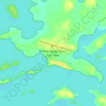
Nom : Carte topographique Cat Lake, altitude, relief.
Altitude moyenne : 398 m
Altitude minimum : 393 m
Altitude maximum : 412 m
Autres cartes topographiques
Cliquez sur une carte pour visualiser sa topographie, son altitude et son relief.
Burditt Lake
Canada > Ontario > Kenora District > Unorganized Kenora District
Altitude moyenne : 367 m
Caliper Lake Provincial Park
Canada > Ontario > Kenora District > Sioux Narrows-Nestor Falls Township
Altitude moyenne : 338 m
Minnitaki Lake
Canada > Ontario > Kenora District > Unorganized Kenora District
Altitude moyenne : 386 m
lac Seul
Canada > Ontario > Kenora District > Unorganized Kenora District
Lac Seul is a large, crescent shaped reservoir in Kenora District, northwestern Ontario, Canada. It is approximately 241 km (150 mi) long. It has a maximum (regulated) depth of 47.2 m, with a surface elevation of 357 m above sea level. Its level is raised in the summer and then drawn down in the winter months…
Altitude moyenne : 374 m
MacDowell Lake
Canada > Ontario > Kenora District > Unorganized Kenora District
Altitude moyenne : 386 m
Lake Charles
Canada > Ontario > Kenora District > Unorganized Kenora District
Altitude moyenne : 346 m
Northwest Angle 33 First Nation
Canada > Ontario > Kenora District > Whitefish Bay
Altitude moyenne : 332 m
Fiddler Lake
Canada > Ontario > Kenora District > Unorganized Kenora District
Altitude moyenne : 293 m
Cardinal (Lac) Lake
Canada > Ontario > Kenora District > Unorganized Kenora District
Altitude moyenne : 392 m
Big Canon Lake
Canada > Ontario > Kenora District > Unorganized Kenora District
Altitude moyenne : 363 m
Sioux Lookout
Canada > Ontario > Kenora District
Sioux Lookout is located approximately 350 kilometres (220 mi) northwest of Thunder Bay, at an elevation of 383 metres (1,257 ft), and it covers an area of 536 square kilometres (207 sq mi), of which 157 square kilometres (61 sq mi) is lake and wetlands.
Altitude moyenne : 377 m
Big Island Lake
Canada > Ontario > Kenora District > Unorganized Kenora District
Altitude moyenne : 430 m
Dogtooth Lake
Canada > Ontario > Kenora District > Unorganized Kenora District
Altitude moyenne : 361 m
Carroll Lake
Canada > Ontario > Kenora District > Unorganized Kenora District
Altitude moyenne : 338 m
Maynard Lake
Canada > Ontario > Kenora District > Unorganized Kenora District
Altitude moyenne : 337 m
Whitefish Lake
Canada > Ontario > Kenora District > Unorganized Kenora District
Altitude moyenne : 380 m
Dingwall Island
Canada > Ontario > Kenora District > Unorganized Kenora District
Altitude moyenne : 325 m
Confederation Lake
Canada > Ontario > Kenora District > Unorganized Kenora District
Altitude moyenne : 414 m
Fredart Lake
Canada > Ontario > Kenora District > Unorganized Kenora District
Altitude moyenne : 409 m
Two Island Lake
Canada > Ontario > Kenora District > Unorganized Kenora District
Altitude moyenne : 361 m
Affleck Lake
Canada > Ontario > Kenora District > Unorganized Kenora District
Altitude moyenne : 421 m
Spadina Lake
Canada > Ontario > Kenora District > Unorganized Kenora District
Altitude moyenne : 376 m
Granite Lake
Canada > Ontario > Kenora District > Unorganized Kenora District
Altitude moyenne : 355 m
McIntosh Lake
Canada > Ontario > Kenora District > Unorganized Kenora District
Altitude moyenne : 395 m
Blackstone Lake
Canada > Ontario > Kenora District > Unorganized Kenora District
Altitude moyenne : 382 m
Winnipeg River
Canada > Ontario > Kenora District > Unorganized Kenora District
Altitude moyenne : 317 m
Grindstone Lake
Canada > Ontario > Kenora District > Unorganized Kenora District
Altitude moyenne : 371 m
Warwick Lake
Canada > Ontario > Kenora District > Unorganized Kenora District
Altitude moyenne : 341 m
Slate Islands
Canada > Ontario > Kenora District > Unorganized Kenora District
Altitude moyenne : 322 m
Lac Seul
Canada > Ontario > Kenora District
Lac Seul is a large, crescent-shaped reservoir in Kenora District, northwestern Ontario, Canada. It is approximately 241 km (150 mi) long. It has a maximum (regulated) depth of 47.2 m, with a surface elevation of 357 m above sea level. Its level is raised in the summer and then drawn down in the winter months…
Altitude moyenne : 388 m
Bertrand Lake
Canada > Ontario > Kenora District > Unorganized Kenora District
Altitude moyenne : 414 m
Nine Mile Lake
Canada > Ontario > Kenora District > Unorganized Kenora District
Altitude moyenne : 413 m
Chisholm Island
Canada > Ontario > Kenora District > Unorganized Kenora District
Altitude moyenne : 323 m
Sioux Narrows Provincial Park
Canada > Ontario > Kenora District > Sioux Narrows-Nestor Falls Township
Altitude moyenne : 329 m
Squirrel Lake
Canada > Ontario > Kenora District > Sioux Narrows-Nestor Falls Township
Altitude moyenne : 360 m
Muskeg River
Canada > Ontario > Kenora District > Unorganized Kenora District
Altitude moyenne : 357 m
Muskeg River
Canada > Ontario > Kenora District > Unorganized Kenora District
Altitude moyenne : 363 m
Tablerock Lake
Canada > Ontario > Kenora District > Unorganized Kenora District
Altitude moyenne : 384 m
Wabaskang Lake
Canada > Ontario > Kenora District > Unorganized Kenora District
Altitude moyenne : 375 m
Minnitaki Lake
Canada > Ontario > Kenora District > Unorganized Kenora District
Altitude moyenne : 386 m
Kukukus Lake
Canada > Ontario > Kenora District > Unorganized Kenora District
Altitude moyenne : 405 m
Antenna Lake
Canada > Ontario > Kenora District > Unorganized Kenora District
Altitude moyenne : 393 m
Berry Lake
Canada > Ontario > Kenora District > Sioux Narrows-Nestor Falls Township
Altitude moyenne : 340 m
Cluster Lakes
Canada > Ontario > Kenora District > Unorganized Kenora District
Altitude moyenne : 443 m
Little Boulder Lake
Canada > Ontario > Kenora District > Unorganized Kenora District
Altitude moyenne : 359 m