
Carte topographique Nagaland
Carte interactive
Cliquez sur la carte pour afficher l’altitude.
À propos de cette carte
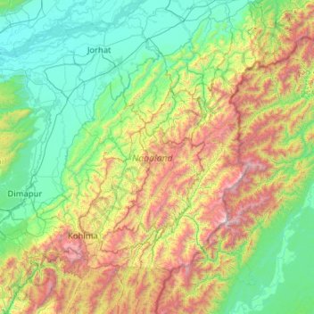
Nom : Carte topographique Nagaland, altitude, relief.
Lieu : Nagaland, India (25.19870 93.32670 27.03580 95.24238)
Altitude moyenne : 824 m
Altitude minimum : 67 m
Altitude maximum : 3 721 m
Nagaland lies between 93°20'E and 95°15'E longitude and between 25°6'N and 27°4'N latitude. It is largely a mountainous state. The Naga Hills rise from the Brahmaputra Valley in Assam to about 610 metres (2,000 ft) and rise further to the southeast, as high as 1,800 metres (6,000 ft). Mount Saramati at an elevation of 3,841 metres (12,602 ft) is the state's highest peak; this is where the Naga Hills merge with the Patkai Range in which form the boundary with Burma. Rivers such as the Doyang and Diphu to the north, the Barak river in the southwest, dissect the entire state.
Autres cartes topographiques
Cliquez sur une carte pour visualiser sa topographie, son altitude et son relief.
Bengaluru
India > Karnataka > Bangalore North
Bengaluru, Bangalore North, Bengaluru Urban District, Karnataka, India
Altitude moyenne : 881 m
Chennai
India > Tamil Nadu > Chennai
Chennai, Chennai District, Tamil Nadu, India
Altitude moyenne : 8 m
3d
India > Rajasthan > Ganganagar Tehsil > 1 LNP
3d, 1 LNP, Ganganagar Tehsil, Sri Ganganagar District, Rajasthan, India
Altitude moyenne : 178 m
Lucknow
India > Uttar Pradesh > Lucknow
Lucknow, Lucknow District, Uttar Pradesh, 226027, India
Altitude moyenne : 120 m
North Sentinel Island
India > Andaman and Nicobar Islands > Ferrargunj
North Sentinel Island, Ferrargunj, South Andaman District, Andaman and Nicobar Islands, India
Altitude moyenne : 20 m
Mambakkam
India > Tamil Nadu > Tiruporur
Mambakkam, Tiruporur, Chengalpattu District, Tamil Nadu, 600127, India
Altitude moyenne : 16 m
Kolkata
Kolkata, Kolkata District, West Bengal, 700073, India
Altitude moyenne : 5 m
Nosal
India > Rajasthan > Roopangarh Tehsil
Nosal, Roopangarh Tehsil, Ajmer District, Rajasthan, 305814, India
Altitude moyenne : 382 m
Bachupally mandal
Bachupally mandal, Medchal–Malkajgiri District, Telangana, 500090, India
Altitude moyenne : 593 m
Gurgaon
India > Haryana > Gurugram District
Gurgaon, Gurugram District, Haryana, India
Altitude moyenne : 237 m
Kodaikanal
Kodaikanal, Dindigul District, Tamil Nadu, India
Altitude moyenne : 869 m
Ward 12
Ward 12, Chandigarh, Chandigarh District, Chandigarh, 160043, India
Altitude moyenne : 326 m
Srinagar
India > Jammu and Kashmir > Srinagar (South)
Srinagar, Srinagar (South), Srinagar District, Jammu and Kashmir, 190001, India
Altitude moyenne : 1 805 m
Indore
India > Madhya Pradesh > Juni Indore Tahsil
Indore, Juni Indore Tahsil, Indore District, Madhya Pradesh, 452001, India
Altitude moyenne : 555 m
Jagdevpur mandal
Jagdevpur mandal, Siddipet District, Telangana, India
Altitude moyenne : 537 m
Suryanelli
India > Kerala > Udumbanchola
Suryanelli, Udumbanchola, Idukki District, Kerala, India
Altitude moyenne : 1 553 m
Mysuru
India > Karnataka > Mysuru taluk
Mysuru, Mysuru taluk, Mysuru District, Karnataka, 570001, India
Altitude moyenne : 727 m
Murbad
India > Maharashtra > Murbad Taluka > Murbad
Murbad, Murbad Taluka, Thane District, Maharashtra, India
Altitude moyenne : 91 m
Vijayawada
India > Andhra Pradesh > Vijayawada (Urban)
Vijayawada, Vijayawada (Urban), NTR District, Andhra Pradesh, 520001, India
Altitude moyenne : 36 m
Prayagraj
India > Uttar Pradesh > Prayagraj
Prayagraj, Prayagraj District, Uttar Pradesh, 211001, India
Altitude moyenne : 91 m
Coimbatore
India > Tamil Nadu > Coimbatore North
Coimbatore, Coimbatore North, Coimbatore District, Tamil Nadu, 641001, India
Altitude moyenne : 452 m