
Faire un don
Équipez-vous pour votre prochaine aventure :
En tant que Partenaire Amazon, ce site perçoit une commission sur les achats éligibles sans surcoût pour vous.
Carte topographique Ward Hill
Cliquez sur la carte pour afficher l’altitude.
Faire un don
Équipez-vous pour votre prochaine aventure :
En tant que Partenaire Amazon, ce site perçoit une commission sur les achats éligibles sans surcoût pour vous.
À propos de cette carte
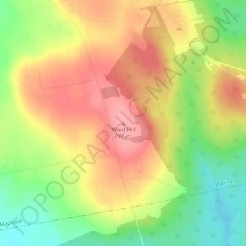
Nom : Carte topographique Ward Hill, altitude, relief.
Lieu : Ward Hill, Maine, 04950, United States (44.78696 -69.81455 44.78706 -69.81445)
Altitude moyenne : 160 m
Altitude minimum : 107 m
Altitude maximum : 204 m
Faire un don
Équipez-vous pour votre prochaine aventure :
En tant que Partenaire Amazon, ce site perçoit une commission sur les achats éligibles sans surcoût pour vous.
Autres cartes topographiques
Cliquez sur une carte pour visualiser sa topographie, son altitude et son relief.
Scarborough
United States > Maine > Cumberland County
According to the United States Census Bureau, the town has a total area of 70.63 square miles (182.93 km2), of which, 47.61 square miles (123.31 km2) is land and 23.02 square miles (59.62 km2) is water. Drained by the Scarborough River, Nonesuch River, Libby River and Spurwink River, the town is situated…
Altitude moyenne : 17 m
Sanford
United States > Maine > York County
Sanford is located at 43°26′23″N 70°46′23″W / 43.43972°N 70.77306°W / 43.43972; -70.77306 (43.439925, −70.773304). According to the United States Census Bureau, the city has a total area of 48.75 square miles (126.26 km2), of which, 47.78 square miles (123.75 km2) of it is land and 0.97…
Altitude moyenne : 103 m
Faire un don
Équipez-vous pour votre prochaine aventure :
En tant que Partenaire Amazon, ce site perçoit une commission sur les achats éligibles sans surcoût pour vous.
Knox County
At an elevation of 1,381 feet above sea level, Mount Megunticook, located in Camden Hills State Park, is the highest point in the county. It ranks 10th in elevation out of Maine's 16 county high points. It is a popular hiking destination in the region.
Altitude moyenne : 29 m
Wells
United States > Maine > York County
According to the United States Census Bureau, the town has a total area of 73.61 square miles (190.65 km2), of which, 57.55 square miles (149.05 km2) of it is land and 16.06 square miles (41.60 km2) is water. Wells is drained by the Webhannet River. The highest point in town is an unnamed hill located a half…
Altitude moyenne : 28 m
Faire un don
Équipez-vous pour votre prochaine aventure :
En tant que Partenaire Amazon, ce site perçoit une commission sur les achats éligibles sans surcoût pour vous.
Faire un don
Équipez-vous pour votre prochaine aventure :
En tant que Partenaire Amazon, ce site perçoit une commission sur les achats éligibles sans surcoût pour vous.
Aroostook County
According to the U.S. Census Bureau, the county has a total area of 6,828 square miles (17,680 km2), of which 6,671 square miles (17,280 km2) is land and 156 square miles (400 km2) (2.3%) is water. Aroostook County is Maine's largest county by area, about the size of Connecticut and Rhode Island combined. The…
Altitude moyenne : 274 m
Faire un don
Équipez-vous pour votre prochaine aventure :
En tant que Partenaire Amazon, ce site perçoit une commission sur les achats éligibles sans surcoût pour vous.
Faire un don
Équipez-vous pour votre prochaine aventure :
En tant que Partenaire Amazon, ce site perçoit une commission sur les achats éligibles sans surcoût pour vous.
Franklin County
According to the U.S. Census Bureau, the county has a total area of 1,743 square miles (4,510 km2), of which 1,697 square miles (4,400 km2) is land and 47 square miles (120 km2) (2.7%) is water. The county is crossed by some of the northernmost parts of the Appalachian Mountain range, with the terrain also…
Altitude moyenne : 428 m
Faire un don
Équipez-vous pour votre prochaine aventure :
En tant que Partenaire Amazon, ce site perçoit une commission sur les achats éligibles sans surcoût pour vous.
Camden
United States > Maine > Knox County
According to the U.S. Census Bureau, the town has a total area of 26.65 square miles (69.02 km2), of which, 18.24 square miles (47.24 km2) of it is land and 8.41 square miles (21.78 km2) is water. Drained by the Megunticook River, Camden is located beside Penobscot Bay and the Gulf of Maine, part of the…
Altitude moyenne : 63 m
Faire un don
Équipez-vous pour votre prochaine aventure :
En tant que Partenaire Amazon, ce site perçoit une commission sur les achats éligibles sans surcoût pour vous.
Blue Hill
United States > Maine > Hancock County
According to the United States Census Bureau, the town has a total area of 86.57 square miles (224.22 km2), of which 62.48 square miles (161.82 km2) is land and 24.09 square miles (62.39 km2) is water. Located on Blue Hill Bay, the town is drained by Mill Brook. Blue Hill, elevation 940 feet (287 meters), is…
Altitude moyenne : 38 m
Faire un don
Équipez-vous pour votre prochaine aventure :
En tant que Partenaire Amazon, ce site perçoit une commission sur les achats éligibles sans surcoût pour vous.
Faire un don
Équipez-vous pour votre prochaine aventure :
En tant que Partenaire Amazon, ce site perçoit une commission sur les achats éligibles sans surcoût pour vous.
Caribou
United States > Maine > Aroostook County
Caribou is located in the geographical center of Aroostook County, at an elevation of 449 feet (137 m) above sea level. The county is readily accessible by two major highways; Interstate 95 from the south and the Trans-Canada Highway (New Brunswick Route 2) from the north and east. In sparsely populated…
Altitude moyenne : 181 m
Faire un don
Équipez-vous pour votre prochaine aventure :
En tant que Partenaire Amazon, ce site perçoit une commission sur les achats éligibles sans surcoût pour vous.
Faire un don
Équipez-vous pour votre prochaine aventure :
En tant que Partenaire Amazon, ce site perçoit une commission sur les achats éligibles sans surcoût pour vous.
Faire un don
Équipez-vous pour votre prochaine aventure :
En tant que Partenaire Amazon, ce site perçoit une commission sur les achats éligibles sans surcoût pour vous.
Newry
United States > Maine > Oxford County
At 20:15 on June 27, 1960, a United States Air Force tanker of the 380th Air Refueling Squadron departed Plattsburgh AFB to refuel a Strategic Air Command bomber. The Boeing KC-97 Stratofreighter rendezvoused with the B-47 Stratojet bomber at an altitude of 15,500 feet in the Fighting Fox aerial refueling area…
Altitude moyenne : 392 m
Bailey Island
United States > Maine > Cumberland County > Harpswell > Bailey Island
Altitude moyenne : 2 m
Faire un don
Équipez-vous pour votre prochaine aventure :
En tant que Partenaire Amazon, ce site perçoit une commission sur les achats éligibles sans surcoût pour vous.
Waterboro
United States > Maine > York County
According to the United States Census Bureau, the town has a total area of 57.16 square miles (148.04 km2), of which 55.33 square miles (143.30 km2) is land and 1.83 square miles (4.74 km2) is water. Lake Arrowhead, named by land developers in the 1960s, is on the northern border of the town. Waterboro is…
Altitude moyenne : 121 m
Verona Island
United States > Maine > Hancock County
The highest point is McCloud Mountain, at an elevation of 344 feet (105 m) above sea level.
Altitude moyenne : 33 m
Faire un don
Équipez-vous pour votre prochaine aventure :
En tant que Partenaire Amazon, ce site perçoit une commission sur les achats éligibles sans surcoût pour vous.
Acadia National Park
United States > Maine > Hancock County > Bar Harbor
The ecological zones at Acadia National Park, from highest to lowest elevation, include: nearly barren mountain summits; northern boreal and eastern deciduous forests on the mountainsides; freshwater lakes and ponds, as well as wetlands like marshes and swamps in the valleys between mountains; and the Atlantic…
Altitude moyenne : 9 m
Faire un don
Équipez-vous pour votre prochaine aventure :
En tant que Partenaire Amazon, ce site perçoit une commission sur les achats éligibles sans surcoût pour vous.
Millinocket
United States > Maine > Penobscot County
The town is crossed by State Route 11 and State Route 157. The town of East Millinocket is located 8 miles (13 km) to the east. Millinocket is the closest town to Mount Katahdin, located in Baxter State Park 20 miles (32 km) to the northwest. At an elevation 5,270 feet (1,610 m), its summit is the highest…
Altitude moyenne : 140 m
Parsonsfield
United States > Maine > York County
The surface of Parsonsfield is quite broken, or more properly, rises into high swells. Ricker's Mountain, in the southwest, is the highest, it being not far from 1,600 feet (490 m) above the level of the sea. Cedar Mountain, in the center, comes up within one hundred feet of Ricker's, while Randall's Mountain…
Altitude moyenne : 174 m
Faire un don
Équipez-vous pour votre prochaine aventure :
En tant que Partenaire Amazon, ce site perçoit une commission sur les achats éligibles sans surcoût pour vous.
Alfred
United States > Maine > York County
According to the United States Census Bureau, the town has a total area of 27.92 square miles (72.31 km2), of which 27.25 square miles (70.58 km2) is land and 0.67 square miles (1.74 km2) is water. Alfred is drained by the Middle Branch of the Mousam River, Littlefield River, Hay Brook and Trafton Brook.…
Altitude moyenne : 111 m
Baxter State Park
United States > Maine > Piscataquis County
After assuming the Maine Senate presidency during the state's 80th legislative session, Percival Baxter appointed his brother Rupert, a Senator from Sagadahoc County, to the Committee on State Lands and Forest Preservation, which would be considering legislation that would create a state park at Katahdin.…
Altitude moyenne : 377 m
Faire un don
Équipez-vous pour votre prochaine aventure :
En tant que Partenaire Amazon, ce site perçoit une commission sur les achats éligibles sans surcoût pour vous.
Faire un don
Équipez-vous pour votre prochaine aventure :
En tant que Partenaire Amazon, ce site perçoit une commission sur les achats éligibles sans surcoût pour vous.
Cliff Island
United States > Maine > Cumberland County > Portland > Cliff Island
Altitude moyenne : 1 m
Rumford
United States > Maine > Oxford County
According to the United States Census Bureau, the town has a total area of 69.85 square miles (180.91 km2), of which 68.55 square miles (177.54 km2) of it is land and 1.30 square miles (3.37 km2) is water. Rumford is located where the Concord, Ellis, and Swift rivers drain into the Androscoggin river. Black…
Altitude moyenne : 280 m
Faire un don
Équipez-vous pour votre prochaine aventure :
En tant que Partenaire Amazon, ce site perçoit une commission sur les achats éligibles sans surcoût pour vous.
Faire un don
Équipez-vous pour votre prochaine aventure :
En tant que Partenaire Amazon, ce site perçoit une commission sur les achats éligibles sans surcoût pour vous.
No Name Pond
United States > Maine > Somerset County > Bald Mountain Township T4 R3
Altitude moyenne : 686 m
Shapleigh
United States > Maine > York County
The town has three mountains over 1,000 feet (305 m): Fort Ridge, Abbott Mountain and an unnamed mountain (1,017 feet / 310 m) located a half mile northwest of Abbott Mountain. Fort Ridge, with its highest summit at 1,114 feet (339.5 m) above sea level, is the town's highest mountain. Abbott Mountain, which is…
Altitude moyenne : 177 m
Faire un don
Équipez-vous pour votre prochaine aventure :
En tant que Partenaire Amazon, ce site perçoit une commission sur les achats éligibles sans surcoût pour vous.
Faire un don
Équipez-vous pour votre prochaine aventure :
En tant que Partenaire Amazon, ce site perçoit une commission sur les achats éligibles sans surcoût pour vous.
South Berwick
United States > Maine > York County
According to the United States Census Bureau, the town has a total area of 32.64 square miles (84.54 km2), of which 32.13 square miles (83.22 km2) is land and 0.51 square miles (1.32 km2) water. Located beside the New Hampshire border, South Berwick is drained by the Great Works River and Salmon Falls River.…
Altitude moyenne : 46 m
Faire un don
Équipez-vous pour votre prochaine aventure :
En tant que Partenaire Amazon, ce site perçoit une commission sur les achats éligibles sans surcoût pour vous.
Faire un don
Équipez-vous pour votre prochaine aventure :
En tant que Partenaire Amazon, ce site perçoit une commission sur les achats éligibles sans surcoût pour vous.
Faire un don
Équipez-vous pour votre prochaine aventure :
En tant que Partenaire Amazon, ce site perçoit une commission sur les achats éligibles sans surcoût pour vous.