
Carte topographique Four Lanes
Cliquez sur la carte pour afficher l’altitude.
À propos de cette carte
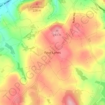
Nom : Carte topographique Four Lanes, altitude, relief.
Lieu : Four Lanes, Cornwall, England, TR16 6NQ, United Kingdom (50.18232 -5.25966 50.22232 -5.21966)
Altitude moyenne : 191 m
Altitude minimum : 112 m
Altitude maximum : 249 m
Autres cartes topographiques
Cliquez sur une carte pour visualiser sa topographie, son altitude et son relief.
St. Columb Major
United Kingdom > England > Cornwall
St Columb occupies a plateau at about 300 feet (91 m) elevation. The north part of the town (known as 'Bridge') descends into the Vale of Lanherne, having a minimum elevation of approximately 165 feet (50 m). It was originally a linear settlement built on the main road running north-east to south-west, but…
Altitude moyenne : 110 m